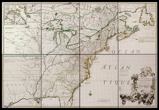
Atlases & Books With Maps
Ortelius’ Great Atlas in Pocket Format
The First Edition Published by Vrients
Atlas.
ORTELIUS, A./ VRIENTS, J. B./ GALLE, F.
[Antwerp, 1601]
A solid copy in its original binding of Filips Galle’s improved version of the first small-scale version of a folio atlas ever published, and the first edition published by Vrients. Ortelius’ groundbreaking, large-format atlas proved to be such an enormously successful publishing phenomenon that it spawned several editions in a...... More
An Atlas of Wall Maps in an Exquisite Italian Binding
Atlas.
NICOLOSI, G. B.
[Rome, 1660]
An atlas of wall maps in an Italian binding of uncommon elegance created for Prince Giambattista Borghese, whose armorial bookplate is on the inside of the front cover. Giambattista Borghese (1639-1717), of the powerful Sienese/ Roman family, was a notable patron of the arts. He purchased the family home that..... More
An Atlas "Writ for a King"
Atlas.
CHIQUET, J.
[Paris, 1719]
Scarce, attractive unusual atlas specifically intended (according to its title) for the entertainment of emperors, kings, and princes. At the beginning of the work are several astronomical plates and illustrations of globes. California is depicted as an island on the world and America maps. Although the title page is undated... More
Paris's Grandeur Depicted on a Grand Scale
Paris.
TURGOT, M./ BRETEZ, L.
[Paris, 1739]
A bright, beautiful copy of one of the most ambitious and finely engraved works of urban cartography ever produced: it depicts every structure existing in Paris at the time. This remarkable engraving enables the viewer to virtually hover a few hundred feet above the city and take in the exquisite... More
The Great Atlas of the French Enlightenment
One of the most important 18th century atlases and one of the great achievements of the French Enlightenment. The Atlas Universel is the prime exemplar of the authors' geographic ideal-- bel et utile--beautiful and useful. "The corpus of their maps displays the finest of eighteenth-century French engraving on copperplate with... More
The Great Mitchell Map, Contemporary-Bound
A very rare, separately published and contemporary-bound example of the French edition of what has been called “the most important map in American history” (Martin). It was the map on which the borders of the newly recognized United States were plotted at the conclusion of the War of Independence. The..... More
Early School Atlas with Original Color
This school atlas of the ancient world appears to have been an academic bestseller through much of Europe in the late 18th and early 19th centuries. Beginning with D’Anville’s orginal French edition in 1768, it would be re-published in England and Germany numerous times through the early 19th century. However..... More
“The Most Important Florentine Atlas” (Valerio)
Atlas.
BORGHI, A. B.
[Florence, 1819]
A superb, contemporary-bound, complete copy of a rare and important Italian atlas. The library of the Senato della Repubblica only acquired a copy of this atlas this year (2008); the atlas is described on the library’s web site (see below for URL) as “one of the rarest specimens complete.” ... ... More
An Attractive, Early American Atlas
Atlas.
MORSE, J. & S. E.
[New Haven, 1822]
First edition of a very capably engraved and attractively colored, "mid-sized" atlas, containing a fine double-page map of the United States, which embodies Lewis & Clark and other, then relatively recent information. When compared to many other contemporaneous maps, this one is more sophisticated in both its cartography and engraving... More
An Early American Missionary Atlas
An unusually well-preserved, scarce, and quite early American atlas of areas where missionary activity was being, or could be conducted. Includes an excellent map exclusively of the Hawaiian Islands. A map entitled “Indian Territory” encompasses Texas and east from Lake Superior and the Mississippi River to the Rocky Mountains in..... More
An Unrecorded Atlas of Boston
Boston.
GEO. H. WALKER & CO.
[Boston, c. 1900]
An unrecorded atlas of the city of Boston, likely originally prepared for a municipal agency. Although the Walker firm produced over the years numerous maps and plans of Boston, we have yet to find the particular ones in this work in public collections or market records. The ten plans of... More
A Beautiful, Finely Hand-Colored Turkish Atlas
Pocket Atlas.
MEHMET CELAL.
[Istanbul, 1908]
Rare, richly hand-colored atlas, showcasing all parts of the world and the Ottoman vilayets, published in Istanbul by Mehmet Celal Bey (1863 – 1926), a Professor of Geography and the Director of Mekteb-i Mülkiye-i Şahane, an Ottoman college, later the School of Economic Science. In 1915, Mehmet Celal, at the..... More
Land Ownership Atlas of Oklahoma
A scarce, pocket land atlas, made for use in the field, of the properties owned by members of the Five Civilized Tribes--the Creek, Seminole, Cherokee, Choctaw and Chickasaw nations. The work remains to this day one of the best and most reliable sources for locating original land ownership titles in... More
Rare Polish Atlas
Of the Post-World War II Recovered Territories
A rare and graphically sophisticated atlas that provides a multi-dimensional picture of the regions of Poland--then called the Recovered Territories--that were ceded back to Poland at the end of the Second World War. In years following World War II, Soviet authorities instituted a Polanization of these territories that had been..... More
A Beautifully Printed, Much Expanded Edition
An elegant, greatly expanded, French-published atlas based in part on of the Carey & Lea atlas of the Americas (Philadelphia, 1822). This edition updates its model in significant ways, adding seven new maps including one of the United States dated 1825. In addition, improvements were made to the maps of... More
Fine American Globe Handbook & Catalogue
A very well-preserved copy of this scarce instructional manual for the use of the globes produced by this highly successful Boston firm. Resourcefully, the hand-book serves a number of other functions. Much of the text provides lesson plans for the teachers using the globe in the classroom by posing several... More
Lovely Guide to Tarpon Fishing in Florida
An uncommonly attractive, very scarce, angling work, with a striking binding featuring a silvered, leaping tarpon, on the lore and "capture" of this celebrated fish. This small-press production, by the The Anglers' Publishing Co., doubled as an early promotional vehicle for Florida tourism, abetted in this by the large folding... More