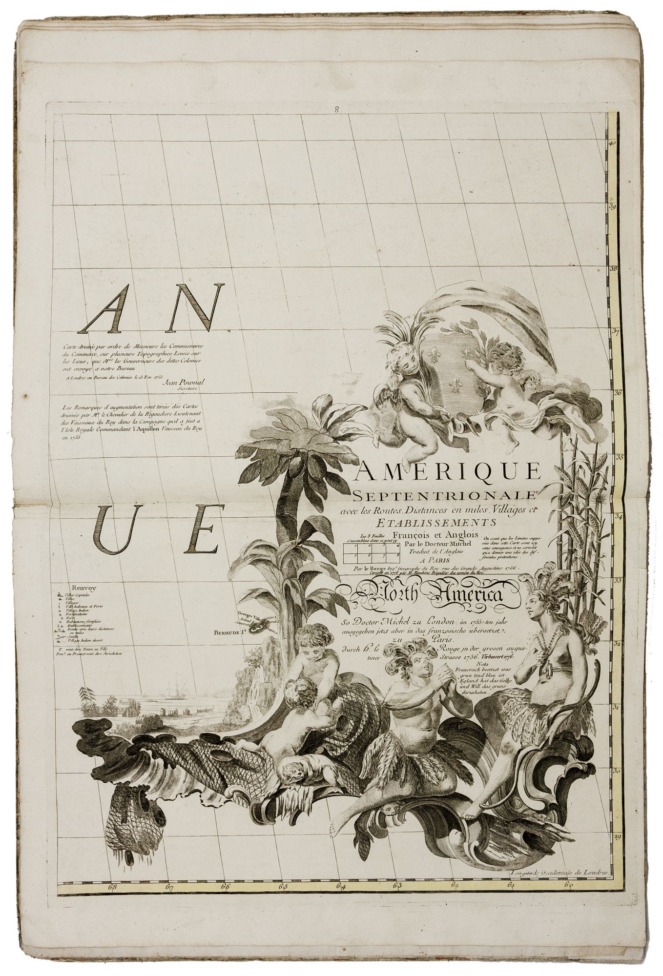
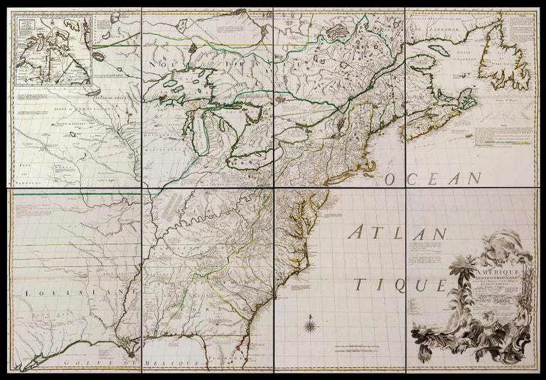
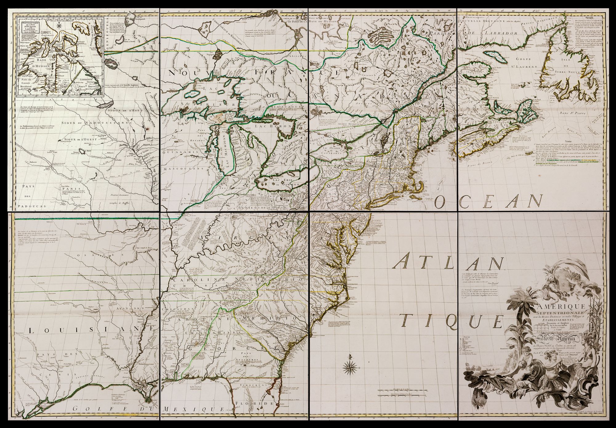
Amerique Septentrionale avec les Routes, Distances en miles, Villages et Etablissements . . . Par le Docteur Mitchel . . . A Paris Par le Rouge . . . 1756…Corigee en 1776 par M. Hawkins Brigadier des armies du Roi.
Printed on eight sheets with original outline color, each approximately 26 x 18 ¾ inches, which assembled together would form a map 53 ½ “ x 76 ¾” . [Bound with:] LE ROUGE, G. [Paris, 1774] L’Amerique Suivant Le R. P. Charlevoix Jte…1774. 19 x 25 inches. Original outline color. Folio bound in contemporary marble-papered boards, spine perishing, yet firmly intact; internally a few stains, else fine condition. Genuine, as issued. A very rare, separately published example (see below) of the French edition of what has been called “the most important map in American history.” Originally published at London in 1755, “Without serious doubt Mitchell’s is the most important map in American history” -- Lawrence Martin, Chief of the Library of Congress Map Division (1924-46). For nearly half a century and more thereafter, its documentary value remained relevant to the climatic events of the young Republic from the French and Indian War through the American Revolution and beyond. Initially, Mitchell’s “map was devised as a conscious cartographic rebuttal to French boundary claims proposed on maps prior to the French and Indian War and it distinguishes British and French possessions in eastern North America and the administrative subdivisions of the British colonies… derived from contemporary maps of every North American province, supplied by the provincial governors…” (Schwartz, p. 160) At the conclusion of the American War of Independence, it “was the cartographic document consulted by official representatives of Great Britain and the United States at Paris in 1782 and 1783 in negotiating the treaty that terminated the Revolutionary War and recognized the independence of the United States.” – Ristow, A la Carte, p. 104. “The map was resorted to in boundary disputes throughout the eighteenth and nineteenth centuries, and even into the twentieth. It served as evidence for the Webster-Ashburton Treaty of 1842, the Quebec boundary definition of 1871, the Canada-Labrador boundary case of 1926, the Wisconsin-Michigan boundary case of 1926, and the Delaware-New Jersey dispute of 1932.” – Schwartz, The Mapping of America, p. 160. The example of the Mitchell map offered here, complete in 8 separate folio sheets, Twenty-one editions and impressions of Mithell’s map appeared in four languages between 1755 and 1783, attesting to its importance. Other than the early English editions, the French edition offered here was by far the most significant, given the history of this map going back to the French and Indian War and forward to the remarkably close and winning alliance between the US and France as the American Revolution developed. Immediately recognizing the importance of Mitchell’s map at the time of its first publication in London in 1755, French map publishers began producing editions of it in 1756. Most often seen on the market, by a wide margin, are examples that were removed from the 1777 edition of Georges Le Rouge’s Atlas Americain septentrional. The far rarer edition offered here appeared a year earlier separately in its own binding at the outset of the American Revolution in response to the French public’s need for information concerning the theatre of conflict. From 1756, 10 distinct impressions of the Mitchell map were issued in French with the final one appearing, appropriately, after March 1783. According to Ristow (p.112), the present edition is the third edition, second impression. It includes the statement “Corigee en 1776 par M. Hawkins Brigadier des armees du Roi.” It is distinguished from earlier impressions by the misspelling of Ticonderoga and the added symbol of its status as a fort. Geographically, “A new lake has been drawn connecting two small lakes, one called ‘Lac George,’ the other, unnamed, on the New York-New Hampshire boundary. The dual lake is represented as flowing into ‘Wood Creek ou Creek du Bois.’” Bound with the eight sheets of the Mitchell map is a rare 1774 edition of Le Rouge’s map of the Western Hemisphere, which curiously shows a Northwest Passage. Martin, L. Dict. of Amer. Biog. vol. 13, p. 51; Ristow, W. A la Carte, Third edition, second impression, p. 112; Schwartz, The Mapping of America, p. 160.
can be purchased as is, bound in its original binding as issued, or assembled to form a large wall map
53-1/2” x 76-3/4” (see image of the assembled map)
for an additional charge.
Price: $25,000.00