Carta particolare della Baia de Messico con la costa.
19 x 30 inches, Fine condition.
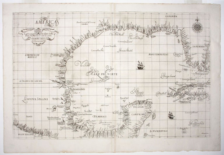
A mint example of the rare first edition of “the first published sea chart of [the Gulf of Mexico] and, therefore, had significant influence on later attempts”—Martin & Martin. Moreover, it is an engraving of singular beauty and is here in optimum condition. Since this chart was plotted on the Mercator Projection, it was also the earliest one of any kind of this area that could conceivably be used for navigation. Other useful navigational information on the chart includes: depth readings for the coasts of southern Florida, Cuba and the southern part of Mexico; notations that describe currents; and the presence of navigational hazards and shoals. A possible explanation for the absence of soundings on the northern half of the chart is that Dudley might have had more personal acquaintance with the southern areas, as a result of the expedition he commanded to Guiana and Trinidad in 1594-95. Also, the northern areas were certainly much less well known at the time. While there are numerous place names along all the coasts included in the chart, most are not identifiable in relation to current places. However, Burden is able to identify the modern counterparts of the names of rivers in Texas on the chart: “R: Montanhas” (Sabine), “R:d’Ouro” (Trinity), “R:Madalena” (Nueces), and he conjectures that the “R:Escondido” is the Rio Grande.
Dudley was one of the most colorful figures among early mapmakers. He was the illegitimate son of Robert Dudley, Earl of Essex, one time paramour of Elizabeth I. This and other familial connections and an interest in the sea put the younger Dudley in contact with the leading explorers of his age, including Drake and Cavendish. However, not able to secure a position commensurate with his abilities in England due to the circumstances of his birth, Dudley made his way to Florence, where he became a valuable courtier to the Medicis and supervised several important engineering projects. His charts reflect both the advantages of his background as well as his technical skills.
In their visual design, Dudley’s charts are utterly unique. The style of the Florentine engraver, Lucini, is perhaps most distinguished by the exquisite grace of the calligraphic lettering, of which there are several fine examples on the present chart. It also contains a fine, large compass rose and two well-detailed ships.
* Burden Martin & Martin, Maps of Texas & the Southwest, pl. 9, pp. 80-1; Lowery 108.
Sold