![Item #9776M Large, Untitled Chart of Long Island Sound, the Connecticut Shoreline, New York City & Vicinity, All of Long Island. [With three large, titled inset charts:] Chart Of Massachusetts Bay…/ Chart Of The East River Entrance To New York … / Hell Gate, And Its Approaches…. CHARLES COPLEY, SONS.](https://martayanlan.cdn.bibliopolis.com/pictures/9776M.jpg?width=768&height=1000&fit=bounds&auto=webp&v=1522091589)
![Large, Untitled Chart of Long Island Sound, the Connecticut Shoreline, New York City & Vicinity, All of Long Island. [With three large, titled inset charts:] Chart Of Massachusetts Bay…/ Chart Of The East River Entrance To New York … / Hell Gate, And Its Approaches…](https://martayanlan.cdn.bibliopolis.com/pictures/9776M_2.jpg?auto=webp&v=1522091589)
![Large, Untitled Chart of Long Island Sound, the Connecticut Shoreline, New York City & Vicinity, All of Long Island. [With three large, titled inset charts:] Chart Of Massachusetts Bay…/ Chart Of The East River Entrance To New York … / Hell Gate, And Its Approaches…](https://martayanlan.cdn.bibliopolis.com/pictures/9776M_3.jpg?auto=webp&v=1522091589)
![Large, Untitled Chart of Long Island Sound, the Connecticut Shoreline, New York City & Vicinity, All of Long Island. [With three large, titled inset charts:] Chart Of Massachusetts Bay…/ Chart Of The East River Entrance To New York … / Hell Gate, And Its Approaches…](https://martayanlan.cdn.bibliopolis.com/pictures/9776M_4.jpg?auto=webp&v=1522091589)
![Large, Untitled Chart of Long Island Sound, the Connecticut Shoreline, New York City & Vicinity, All of Long Island. [With three large, titled inset charts:] Chart Of Massachusetts Bay…/ Chart Of The East River Entrance To New York … / Hell Gate, And Its Approaches…](https://martayanlan.cdn.bibliopolis.com/pictures/9776M_5.jpg?auto=webp&v=1522091589)
![Large, Untitled Chart of Long Island Sound, the Connecticut Shoreline, New York City & Vicinity, All of Long Island. [With three large, titled inset charts:] Chart Of Massachusetts Bay…/ Chart Of The East River Entrance To New York … / Hell Gate, And Its Approaches…](https://martayanlan.cdn.bibliopolis.com/pictures/9776M_6.jpg?auto=webp&v=1522091589)
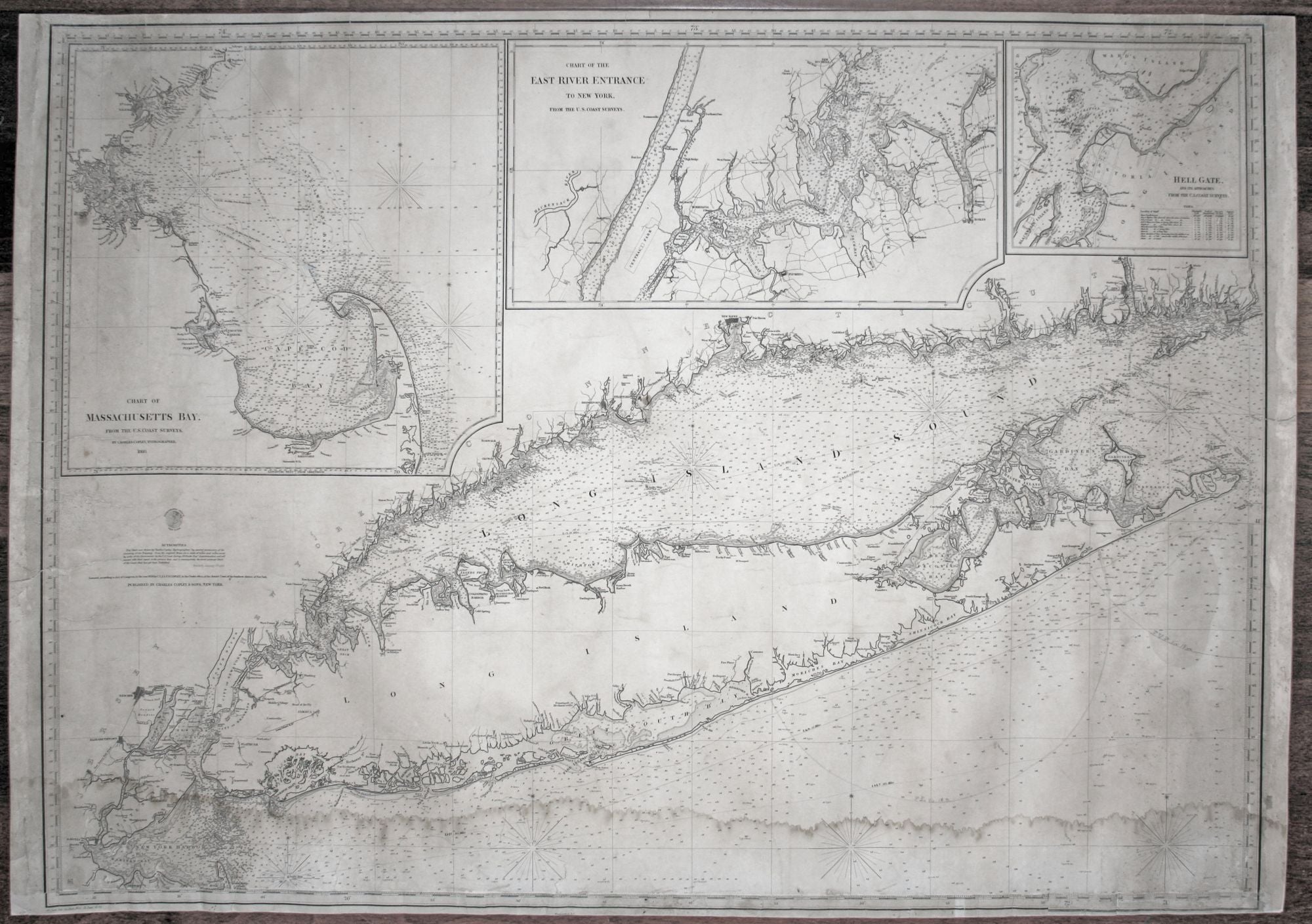
Large, Untitled Chart of Long Island Sound, the Connecticut Shoreline, New York City & Vicinity, All of Long Island. [With three large, titled inset charts:] Chart Of Massachusetts Bay…/ Chart Of The East River Entrance To New York … / Hell Gate, And Its Approaches….
33 x 47 inches, Some early navigational markings in pencil; expertly conserved & re-mounted on heavy blue backing; much of lower engraved border facsimilized; otherwise some edge wear and some split entered side surfaces; some water staining to lower portion of chart; no loss to chart area & surface largely bright with dark printing impression; overall good to very good condition. Rare. This was as authoritative a chart of these waters as was available at the time. Despite its density of detail, the chart was engraved with uncommon clarity. Its charting of the Connecticut shoreline includes the many, small harbor islands, especially along the western shore. Also, all inlets, rivers and streams entering the larger waters are detailed. Even roads with the locations of dwellings, rail lines, and other historically interesting detail (e.g. Central Park a year before its official opening) are shown. Various types of shading indicate the nature of the bottom along the shorelines, and the customary navigational data—depths, hazards, currents, lighthouses, etc.—is fully given. The large inset chart of upper left of Cape Cod and Boston bays is also remarkably well-detailed, especially in Boston Harbor itself. Not only are preferred shipping lanes shown, but also the chart provides a good sense of the extent to which Back Bay was filled in at the time. The quality of the engraving here is not surprising given that Copley spent the first part of his career as an engraver for hire; notably, he both drew and engraved charts for the prolific nautical publishers, the Blunts. In fact, Copley’s work address in 1846 at 16 Burling Slip in New York was close to that of the Blunts. As is noted on the main Long Island chart, the information for this chart derived primarily from the most recent work of the U. S. Coastal Survey, for which Copley worked earlier in his career. Calling his establishment the “Hydrographic Office” on the chart, Copley appears to be suggesting some official status, which was not the case. The fact of the matter is that charts of the areas depicted on this chart were at the time available from the U. S. Coast Survey, and probably more cheaply. Guthorn suggests why, despite the above, there was still a market for what Copley’s chart offered with the following observation: “Small scale charts were favored by shipmasters, with large scale inset charts of harbors. This aided coastwise navigation, and inshore and harbor piloting with a minimum number of charts” (p. 58).This is precisely what this fine chart accomplishes. Guthorn, P. United States Coastal Charts, pp. 11-12, 58; Rittenhouse, Vol. 2, No. 2, pp. 54-55.
Sold