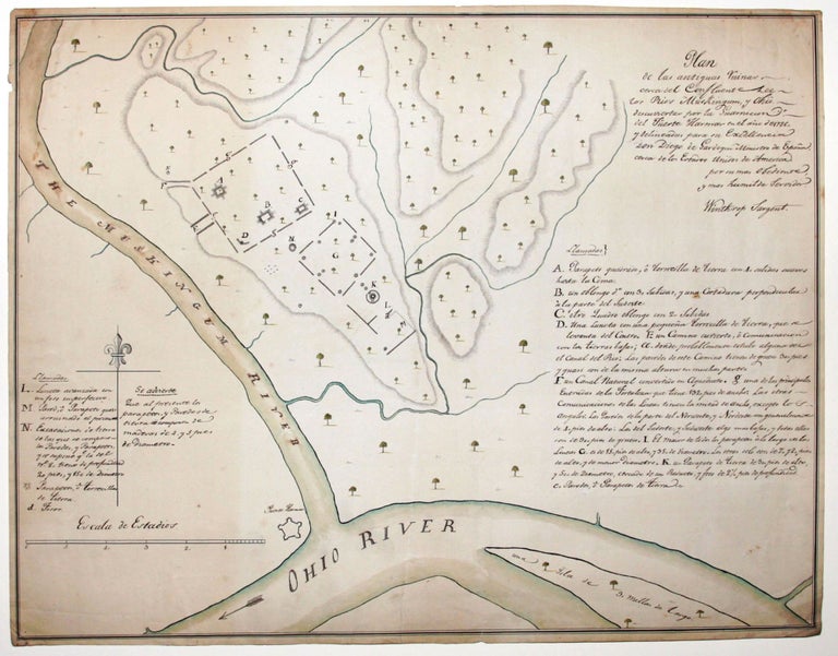
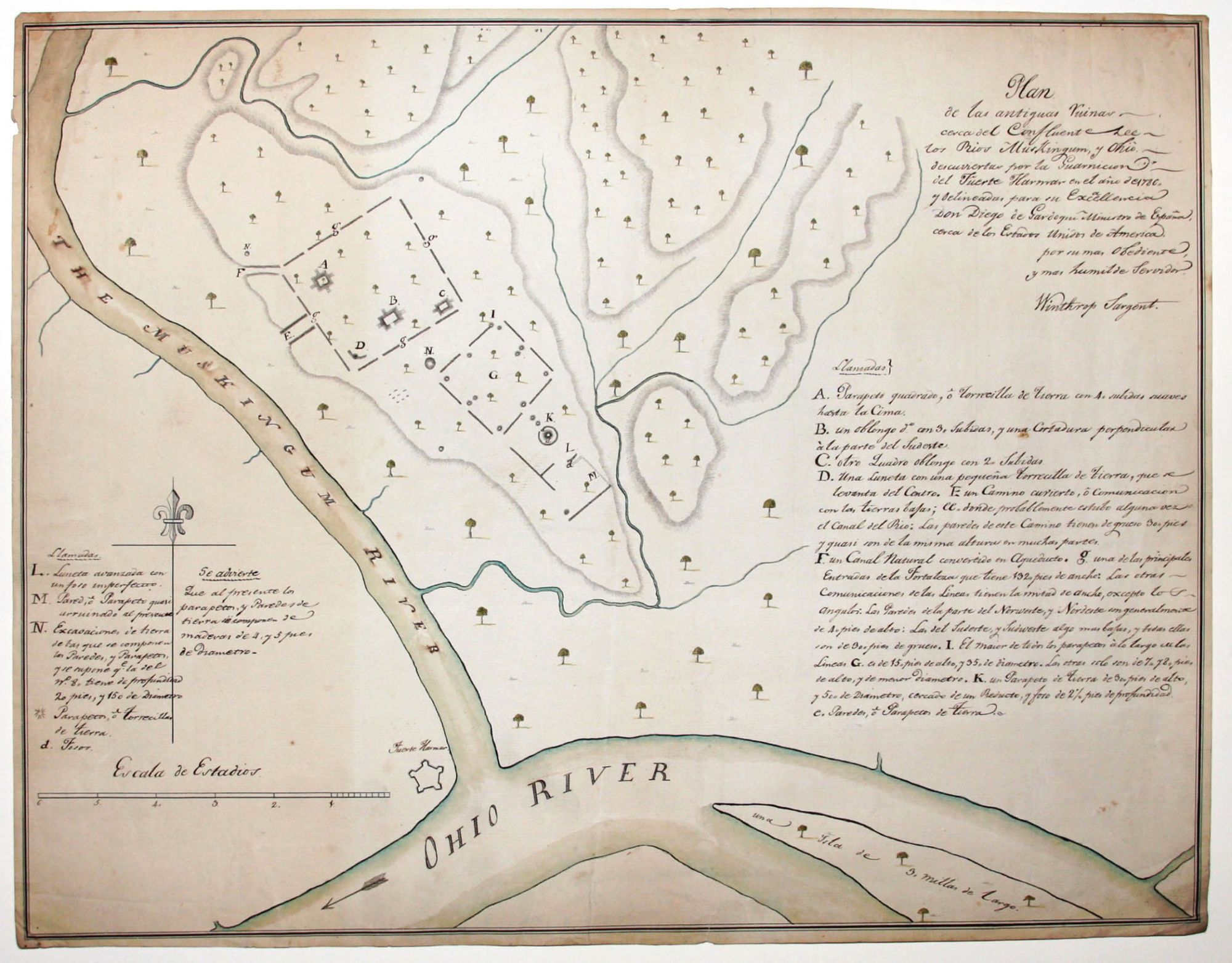
Plan de las antiguas Ruinas….
15 ¾ x 20 ½ inches, Pen & ink & watercolors on laid paper; lightly toned, a mended split, else excellent condition.
A highly finished eighteenth-century manuscript survey of what was at the time one of the forward areas of the American frontier. The area depicted is at the intersection of the Ohio and Muskingum rivers in southeastern Ohio, which today is largely occupied by the city of Marietta. The map’s probable date can be closely bracketed by the following the facts: Marietta, which was founded in 1788, is not on the map, while Fort Harmer, found 1785, is present. Also, the map’s inscription states that the earthen formations (discussed below) depicted on the map were discovered in 1786. Finally, another manuscript version of this map, in English, is dated 1787.
The map’s principal subject is the vast earthen formations or Indian mounds in the area that inspired wonder and curiosity in early travelers and settlers in the area. Sargent’s map is contemporaneous with the very earliest cartographic depictions of these formations; see Smith (reference below), p. 38. This subject proved to be no less than the spawning ground for an indigenous American archeology, and this map was in the vanguard of this development. “There is little doubt that the study of archaeology in the United States during the major part of the nineteenth century was concentrated around the antiquities located in the state of Ohio and in the Ohio Valley, and that it gave to American men of learning a topic for consideration that promoted American scholarship independently of European initiative” (Smith, p. 33). Sargent sent the English version of the present map, mentioned above, to the American Academy of Arts and Sciences in Cambridge, Massachusetts. This manuscript map, which is in Spanish, was made for presentation to Don Diego Gardoqui, the first ambassador of Spain to the United States, by Winthrop Sargent, a surveyor and central figure in the settlement of Ohio as a principal in the various land development companies operating there and as Secretary of the Northwest Territory. While it is unlikely the map was done in Sargent’s own hand, there is little doubt it was made at his behest. In fact, its highly respectful inscription and the presence of Sargent’s name on it as if it were a signature suggest that this map was very much a personal gesture from Sargent to Gardoqui.
This intriguing provenance, the unlikely pairing of the staunch Yankee frontier surveyor/ land developer with the cosmopolitan European diplomat, opens a window on a complex and not well understood aspect of the settlement of the American frontier in Ohio and elsewhere. While archival records do not reveal a close relationship between the men, there is no doubt that they traveled in intersecting circles and were quite aware of each other. For example, a letter from Henry Knox to Sargent (see reference below), found in the Massachusetts Historical Society, which houses Sargent’s papers, speaks of Gardoqui as someone both Knox and Sargent were acquainted with. But one needs to first better understand the larger context of the complex relationship between United States and the Spanish Crown in regard to the settlement of the American frontier to begin to get a sense of how this map might have fit in. Spain at the time held title to the vast Louisiana Territory west of the Mississippi as well as to navigation rights to the Mississippi River. Pressing outward toward the Mississippi at the time were American settlers from the growing eastern colonies. Spain’s dilemma was how to maintain a position of strength in the areas it held, when it did not have the ability to colonize it in any substantial way. Records in Spanish archives suggest that Spanish strategy was initially to foster American settlement of the Ohio territory as well as areas further south through financial inducements to potential settlers. In fact, records in Spanish archives (see below) show that between 1781 and 1787, Spain advanced monies to support American settlement in Ohio, and as Spain’s ambassador to the United States, Gardoqui appears to have been the chief dispenser of these funds. The second phase of the strategy was to induce settlers to remove to Spanish-held territory and there become Spanish citizens. While offering a variety of inducements, perhaps the major carrot was navigation rights to the Mississippi River, which Spain had suspended for Americans from 1785 onward. Spain perhaps felt that it could lure a sufficient supply of Americans--some disgruntled with their own government as well as some former Loyalists--to provide the beginning of a population pool for its territories. Some of these efforts did come to fruition, with perhaps the best known being New Madrid, founded in 1788 by George Morgan of Kentucky, on land granted by Gardoqui himself on the west side of the Mississippi River, opposite the mouth of the Ohio River.
It is probable that Sargent may have been in one way or another the beneficiary of some of the largesse dispensed by Gardoqui. The warmth of map’s inscription supports the notion that Sargent had been in some manner in Gardoqui’s debt. Spanish archives further reveal that Gardoqui was especially active in trying to acquire maps of the American interior (see reference below). It is therefore possible that this map was Sargent’s response to the importunities of the Spanish ambassador to provide a map. And such a map, with its academically tinged subject matter, was perhaps an innocuous way for Sargent to pay a debt to a patron without being seen to convey sensitive cartographic information.
In 1855, a printed version of the manuscript map mentioned above that Sargent had sent to the Academy of Arts and Sciences was published in conjunction with a lecture being given there on the Ohio Indian mounds. And in 1826, a map very like Sargent’s appeared in Collot’s Voyage d’un l’Amerique under the title, “Plan d’un Ancien Camp Retranche’…” But the maker of the map is identified as a Captain John Hart, who most likely was Dr. John Hart, who like Sargent was a former Revolution War officer, a founder of the Society of the Cincinnati, and active in the development of the Ohio territory. In addition, there is in the Bibliotheque de Service Hydrographique in Paris (C4044-14) an anonymous manuscript map, in English, again very like Sargent’s; it is either dated 1790 or assigned this date. It may have been Collot’s source.
Winthrop Sargent (1753-1820) was an artillery officer in the American Revolution, who was active in several battles almost through the entire duration of the war. He was a founding member of the Society of Cincinnati. In 1786, Sargent helped to survey the Seven Ranges, the first lands to be laid out under the Land Ordinance Act of 1785. He was the first secretary of the Northwest Territory, the second highest position in the government of the area. With intimate knowledge of the area, he went on to form the Ohio Company of Associates and was an important shareholder in the Scioto Company. He was governor of the Mississippi Territory from1798 to 1801, after which he became a planter in Natchez for the reminder of his life.
Don Diego Gardoqui (1735-1798), served as Spain’s first ambassador to the United States until 1789, having arrvied in New York in 1785, but he continued to serve as a minister to the United States until his death.
* Smith, T. The Mapping of Ohio, pp. 32-43; Sargent Papers at MHS, Letter Knox to Sargent, Sept. 29, 1788; Archivo General De India, Signatura CUBA,600; Área De Contenido Y Estructura; Alcance Y Contenido: Correspondencia De Diversas Autoridades. Legajo 600. [1778-1788, 1793-1806, 1809-1810, 1812.]
Sold