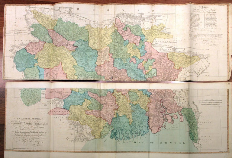
An Actual Survey of the Provinces of Bengal, Bahar &c. By Major James Rennell, Engineer, Surveyor General to the Honourable East-India Company.
Original color; four sheets, joined to make two folding maps, 54 x 147 cm (21.2 x 57.8 inches) and 44.5 x 147 cm (17.5 x 57.8 inches) respectively. Mounted together the map measures 98.4 x 294 cm (38.7 x 115.7 inches), not including margins. Numbered 54 and 55 in the margins. Mended splits at folds and margins with no loss, light toning, very good. A very attractive example in full, original, wash coloring of one of the first surveys of the province of Bengal. The surveys were performed by James Rennell, appointed Surveyor General by the East India Company in 1767 and known as “The Father of Indian Geography.” His greatest work is considered The Bengal Atlas, published in 1779. In 1777, Rennell returned to London, where he continued his geographical research and cartographic work. In 1781 he was elected member of the Royal Society and ten years later was awarded the Copley Medal--the Society's most prestigious sign of recognition. The map provides great topographical details, including roads, mountains, and rivers, which made it a great resource for British strategic and administrative needs. In 1757, the British East India Company won the Battle of Plassey over the Nawab of Bengal and his French allies, allowing company to gain control of Bengal and subsequently of most of the Indian subcontinent, Myanmar, and Afghanistan. The region of Bengal served as an important supplier of cotton, silk, indigo dye, saltpeter, and tea to the English metropole and contributed to its industrial revolution. The map appeared in A new universal atlas, exhibiting all the empires, kingdoms, states, republics, &c. &c. in the whole World... including all the tracks and new discoveries of the British circumnavigators, Biron, Wallis, Carteret, Captain James Cook, Vancouver, Perouse, &c. &c., first published by Laurie and Whittle, starting in 1796. Robert Laurie (ca. 1755-1836) and James Whittle (1757-1818) became partners in London, on Fleet-street upon the death of their employer, distinguished engraver and mapmaker Robert Sayer. Laurie retired from business in 1812, with the firm continuing as Whittle & Laurie run by his son, Richard Holmes Laurie, who became the company's only owner upon the death of Whittle in 1818. *Rumsey 2310.065 (1794 edition); Shirley, Maps in the Atlases of the British Library, T.LAU-1c (1799 ed.).
Price: $2,850.00