
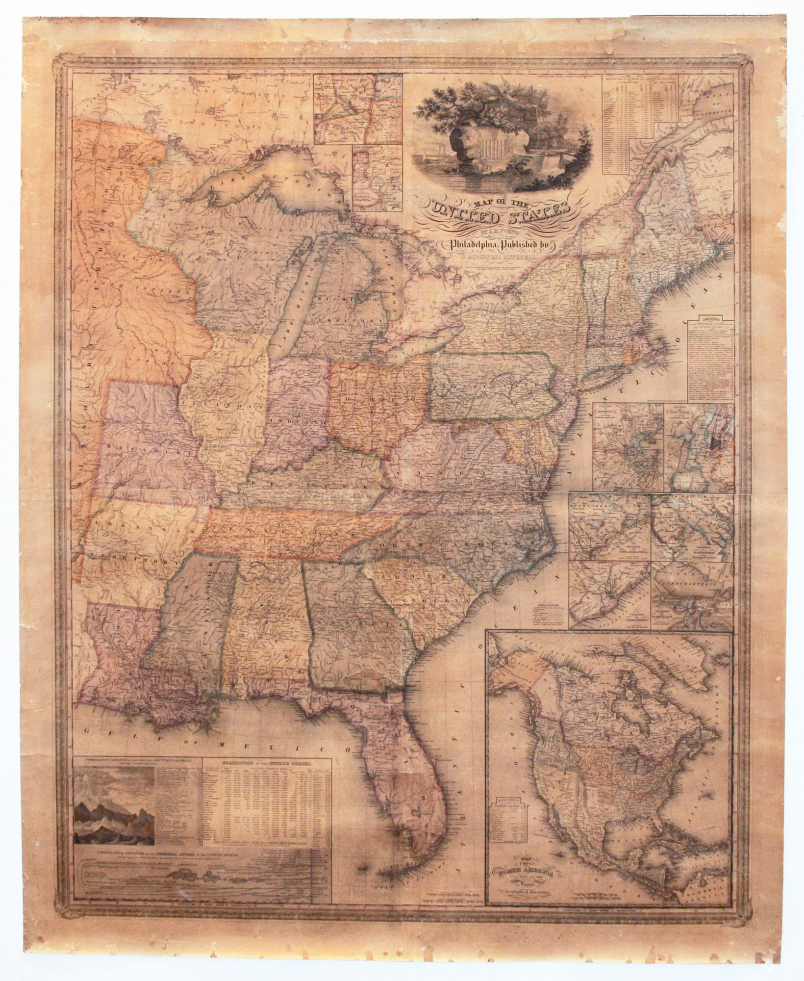
Map Of The United States.
43 3/8 x 34 1/2 inches. Original wash color, refreshed; fully conserved & stabilized, re-mounted on new linen; toned, slight abrasion, overall very good.
The rare, first edition of Mitchell's first wall map as well as his first, original cartographic publication. Mitchell published other maps and an atlas in 1831, but these were re-issues of works by Finley. This very skillful and information-filled wall map launched the Mitchell firm to a position of dominance in cartographic publishing that it would not relinquish for over two decades.
This map was also very likely the first, large-scale one to have been steel plate-engraved. Mitchell's company was the first to make extensive use of steel plate engraving. The sharp, clean lines of this map speak to one of the advantages of this process; the durability of the plates, especially relative to copper, was certainly another. Only the firms of Mitchell and Colton made extensive use of the process, which was superseded by the less costly and infinitely easier process of lithography.
Much was added to this map that made it a very attractive product. There are eight inset maps of major urban areas, including New York, Boston, New Orleans, and Washington/ Baltimore. A very good, large inset map of North America displays "all the recent Geographical Discoveries" as well as the limits of the various western territories. At lower left are comparative profiles of mountains and the lengths of major rivers. A most interesting table gives the populations of the states and territories for the decades beginning 1790; for 1830, the population figures are broken down among whites, freed blacks, and slaves. Also, the populations of over 30 cities are given in order of size. A finely engraved vignette above the cartouche celebrates the then dramatic advances in transportation: a steam boat at left, a canal lock being operated at right, and, faintly visible cutting through the forest at center, a very early locomotive. All of this surrounds the crest of the United States. The Mitchell firm clearly succeeded in making its inaugural production a most formidable one.
Samuel Augustus Mitchell (1792- 1868), born in Bristol, Connecticut, spent most of his professional life in Philadelphia, where he had a long and fruitful partnership with James H. Young (fl. 1817-66), who receives authorship credit on this map. Young, often with others, engraved many of Mitchell's maps and was also the compiler and draftsman of several. Mitchell's role was that of editor, publisher and business manager.
* Rumsey 2723; Ristow, p. 309.
Sold