![Item #6026 The Map of China [Huang Ming yitong fang yu bei lan -- Comprehensive view map of the Imperial Ming]. CHINA, Samuel PURCHAS.](https://martayanlan.cdn.bibliopolis.com/pictures/6026.jpeg?width=768&height=1000&fit=bounds&auto=webp&v=1652807989)
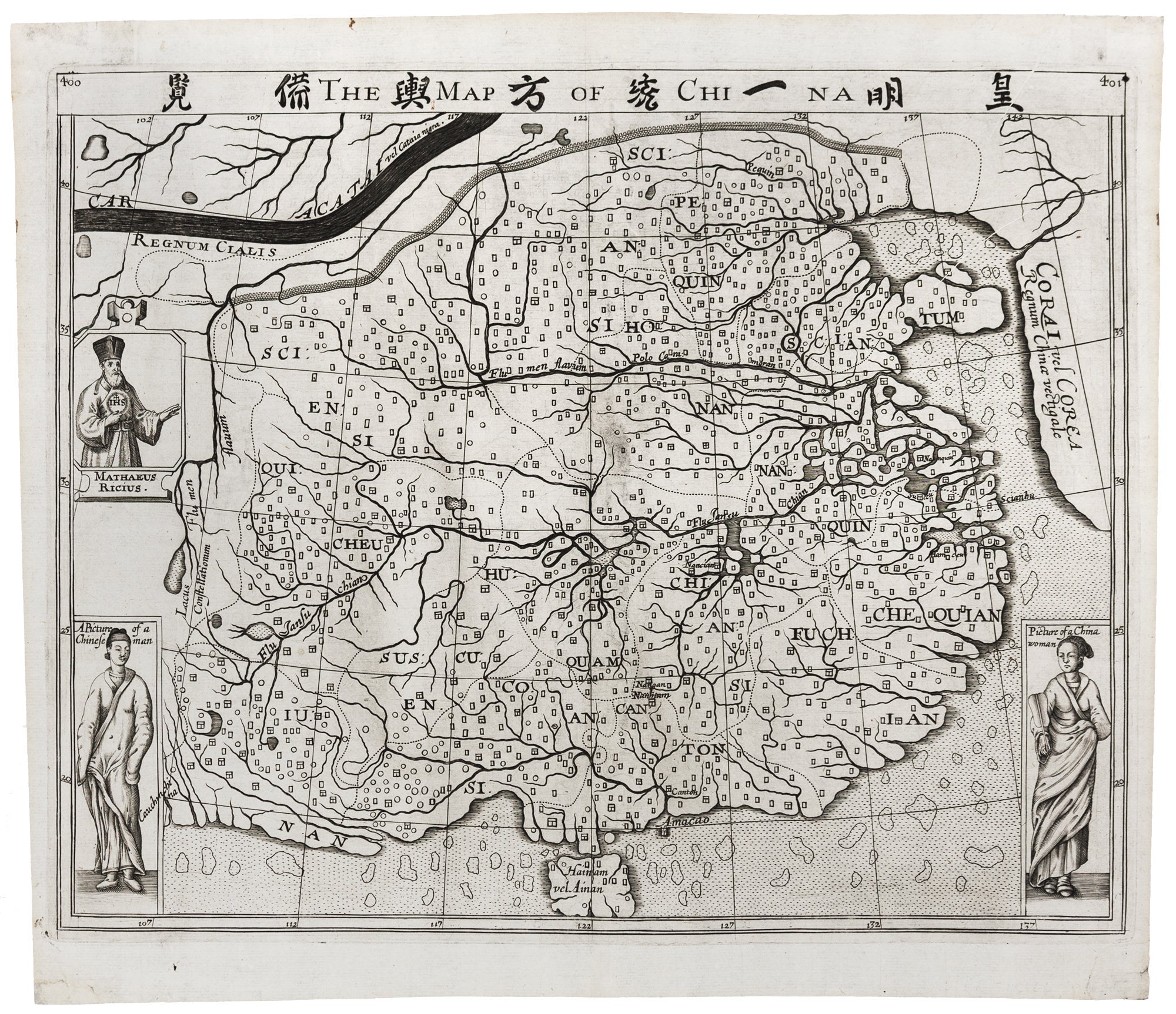
The Map of China [Huang Ming yitong fang yu bei lan -- Comprehensive view map of the Imperial Ming].
14.5 x 11.5 inches (36.8 x 29.2 cm). Minor mend at very tip of blank corners; overall excellent. Only edition of the first map of China engraved and printed in England. With its illustrations of a Chinese man and a Chinese woman dressed in their traditional Chinese garb, it must have been a remarkable sight for an English audience highly unlikely to have set eyes on an in-the-flesh Chinese person in England before this time. Nor, at a time when anti-Jesuitical feelings were strong, is the portrait in the upper left of the map honoring Matteo Ricci, the Italian Jesuit priest holding an emblem of the Jesuit order in his hands, any less remarkable as the European face of the Jesuit missions in China. Historically, this map is widely considered to be the first European map of China based directly on a Chinese source, allegedly the Cao map of 1593, which was brought to England by the merchant John Sarls having acquired it at the port of Bantam (in modern Indonesia) as settlement of a debt on one of his several voyages to Southeast Asia. According to the author Samuel Purchas in his book Purchas His Pilgrims, this Chinese map then passed to Richard Hakluyt, the famed travel writer, from whom Purchas acquired it. Deriving whatever he could from this Chinese map, given the limited resources in London for understanding Chinese cartography, language nor significant availability of Chinese printer’s type, Purchas employed it as best as he could to produce the present Map of China – the first of its kind to be made, engraved, and printed in England - to illustrate his multi-volume work of English travel literature printed in 1625-6. Cartographically, Purchas’ map shows the provinces of China marked and with the boundaries shown, perhaps for the first time on a western map. Korea is represented as a peninsula, unusual for a map of this period. Sanson, perhaps the most prolific and scholarly French mapmaker of the 17th century, employed it as a template for his map of China, modifying it considerably over the course of the century. Purchas’ map was also the model for the maps of China by De Bry and Semedo altogether making it a map with an impact and of considerable influence.
*Purchas, Samuel, Purchas his Pilgrimes, London, Printed by William Stansby for Henrie Fetherstone, 1625-6; Szczesniak, B. The Seventeenth Century Maps of China… Of European Cartographers, Imago Mundi, Vol. 13 (1956) pp. 116-136.
Sold