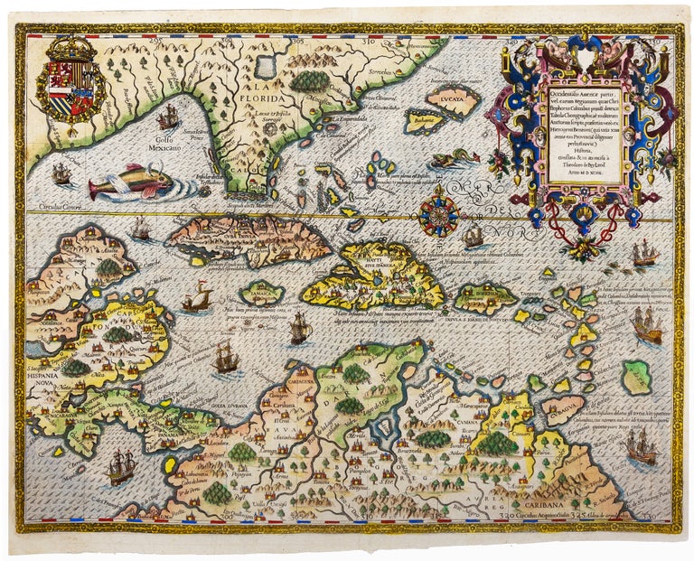
Occidentalis Americae partis, ve, earum Regionum quas Christophorus Columbus.
33 x 43.9 cm (13 x 17.2 inches). Superb hand color, heightened with gold. Excellent. One of the masterworks of early modern map engraving and among the earliest focused depictions of the West Indies within the context of the Gulf of Mexico, Florida, the Yucatan, Panama, and the northern coast of South America. A principal aim of the map is to show the discoveries of Columbus; and accordingly, various legends on the map mark the significant events during the Admiral’s exploration. A cross marks Gunahani or Columbus’ first landfall and sea monsters abound in the waters dwarfing ships with billowing sails. It would not be surprising if the publisher De Bry had in mind a kind of commemoration when he financed this spectacular engraving with its disproportionately large representations of the islands Columbus visited on his 4 voyages and the intricately-designed cartouche, with the royal coat of arms of Spain, which financed Columbus’ voyage: de Bry would have known that the first official printed announcement of the discovery of America published in 1493 was issued just over 100 years before. *Burden 83.
Price: $11,500.00