Urbis Romae sciographia ex antiquis monumentis accuratiss(im)e delineata.
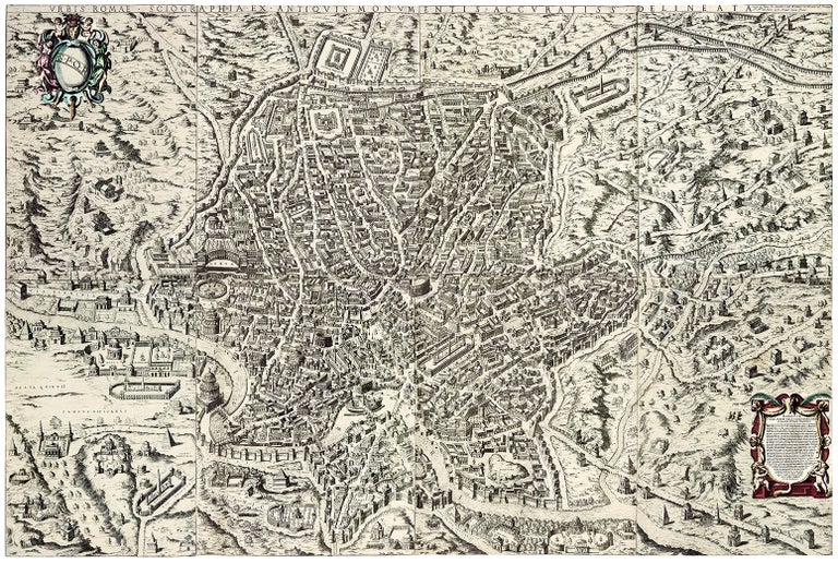
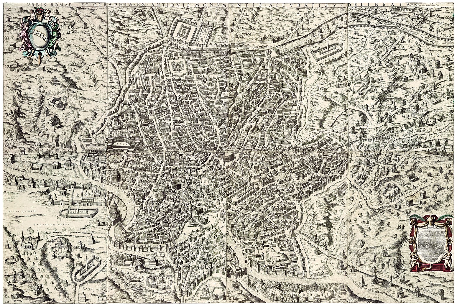
8-sheet etching assembled 157 x 105 cm., trimmed to neatline, map verso with some repairs and reinforcements where leaves are joined; occasional fraying and wear at edges; unimportant small puncture; cartouches hand colored. Otherwise in good condition for a wall map which has survived intact and without backing. Rare and attractive wall map of ancient Rome by Étienne Du Pérac (c. 1525-1604), his “original and ambitious” (Maier, p. 134) monumental etching on 8 sheets reconstructing the imperial city based on the most up-to-date archeological evidence available at the time of the print’s creation in 1574. Du Pérac’s Urbis Romae sciographia is “perhaps the finest single work” (Maier, p. 33) of the Roma antica genre of cartography as pioneered by the antiquarian-architect Pirro Ligorio (c. 1512-83) in his Rome plans of 1552 and 1553. Earlier attempts to recreate the cityscape of ancient Rome (e.g., Bufalini’s 1551 map) awkwardly mixed monuments from different eras, but in the second half of the sixteenth century, there was a move toward clear separation of past and present: “Maps of modern Rome became increasingly faithful to the current state of the urban fabric and its architecture, while those of the ancient city, which developed into an independent and immensely popular category, were given over to reconstruction” (Maier, p. 119). Du Pérac here leans not only on the scholarship of Ligorio and other antiquarians, but also on ancient cartography itself, namely the recently excavated fragments of the Forma Urbis, the ichnographic marble plan dating from the time of Septimius Severus (r. 193-211) and rediscovered only in 1562. Du Pérac’s etched plan is oriented with the traditional manner (for the sixteenth century) with the northern entry (Via Flaminia) to Rome at the left. Many extant ancient monuments are instantly recognizable, including the Aurelian walls, the Colosseum, Pantheon, pyramid of Gaius Cestius, Circus Maximus, Antonine Column, Trajan’s Column, etc., while others have been stripped of their medieval and Renaissance accretions and returned to their pristine classical glory (e.g., the Castel Sant’Angelo depicted in its original form as the Mausoleum of Hadrian). Most structures, however, are supplied from ancient texts, archeological finds, and the imagination. In his dedication to Charles IX of France (r. 1560-74) at the bottom right, Du Pérac explains the motivations and sources for his plan: “Duperac emphasized his own extensive investigations of Roman ruins. He reported that he had spent fifteen years ‘with great labor’ on the study of these ruins ‘with very diligent investigation, very acute observation, [and] very accurate description.’ He had also studied inscriptions, broken stones and ruins, remains of every kind of ancient thing and had described them very diligently, ‘noting constantly in what place each thing was discovered and excavated.’ He had, he noted, consulted relevant writings of the ancients, ‘having called in the judgement of very erudite men.’ Finally, with the permission of Cardinal Alessandro Farnese, he had carefully inspected the marble fragments of the ichnographic map discovered near the church of Santi Cosma e Damiano (the Forma Urbis Romae discovered by Giovanni Dosio in 1562). He noted that despite the difficulties of arranging the pieces correctly, ‘it was of great help to me’ in making the map” (Long, pp. 151, 153). The ancient marble map of Rome would continue to inspire artists working in the Roma antica genre, most famously Giovanni Battista Piranesi, who depicted fragments of the Forma Urbis is his 1756 Pianta di Roma and frequently quoted it in his 1762 Campus Martius Antiquae Urbis. The learned cartographic fantasies of Du Pérac’s Urbis Romae sciographia, at once imaginative and plausible, thus would find their ultimate adherent in Piranesi whose maps and views were made on the eve of the rise of professional archeology in the modern sense. Born in Bordeaux, Du Pérac was one of a number of French artists who settled in Rome. He worked with the influential publisher Antonio Lafreri (himself a native of France). “After his arrival in 1559, Du Pérac became well respected for his technically accomplished drawings and prints of the ruins, which he contributed to the projects of several learned antiquarians, including not just Ligorio, but also Onofrio Panvinio. Among other works, Du Pérac is credited with designing, etching/engraving, and publishing (independently or with Lafreri and others) several maps, many architectural images, and a book comprising evocative views of Roman ruins (I vestigi dell’antichità di Roma, 1575) over the course of his career” (Maier, pp. 133-4) The publication history of Du Pérac’s Urbis Romae sciographia has only recently been confirmed (by S. Bifolco and F. Ronca), and general confusion still exists in otherwise excellent sources. Du Pérac designed and etched the plates in 1574. The publisher Lorenzo Vaccari (fl. 1674-1608) added his name below the dedication and first printed these plates. Vaccari’s association with the Urbis Romae sciographia was known though print catalogues of the Vaccari firm, but a complete example was not located until S. Bifolco and F. Ronca pointed to the copy in the Newberry Library. The second state of the Urbis Romae sciographia has Vaccari’s name replaced by that of Francesco Villamena (c. 1565-1624). This second state was long incorrectly considered to be the first state, with only one extant example (British Library) known; Bifolco and Ronca uncovered two further examples of the Villamena second state (BnF and Museo di Corso, Rome). The third state, offered here, is the earliest acquirable today. It has Villamena’s name replaced by that of Giovanni Giacomo de Rossi (active after 1649), which is also added at the upper right after the title. Columbia and the Getty are the U.S. institutions preserving examples of this third state (OCLC). The copperplates survive in the Calcographia in Rome and were reprinted in the 1730s (the 4th state, with “Calcographia Camerale” newly engraved in the copperplates). *S. Bifolco and F. Ronca, Cartografia e topografia italiana del XVI secolo, vol. 3, pp. 2358-9, no. 3; Frutaz, Le Piante di Roma, v. 1, p. 22, 67-68, no. XXII; Hülsen, Saggio, xi, pp. 60-62, nos., 56-9; ; J. Maier, Rome Measured and Imagined: Early Modern Maps of the Eternal City; P. O. Long, Engineering the Eternal City.
Sold