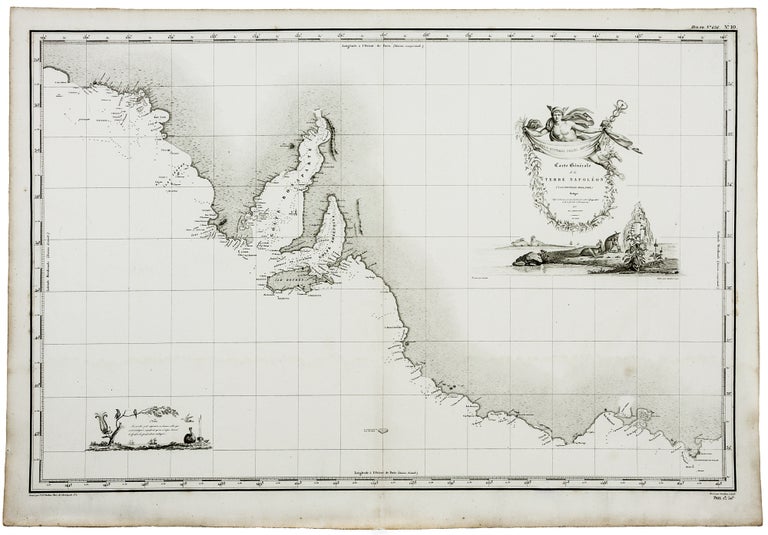
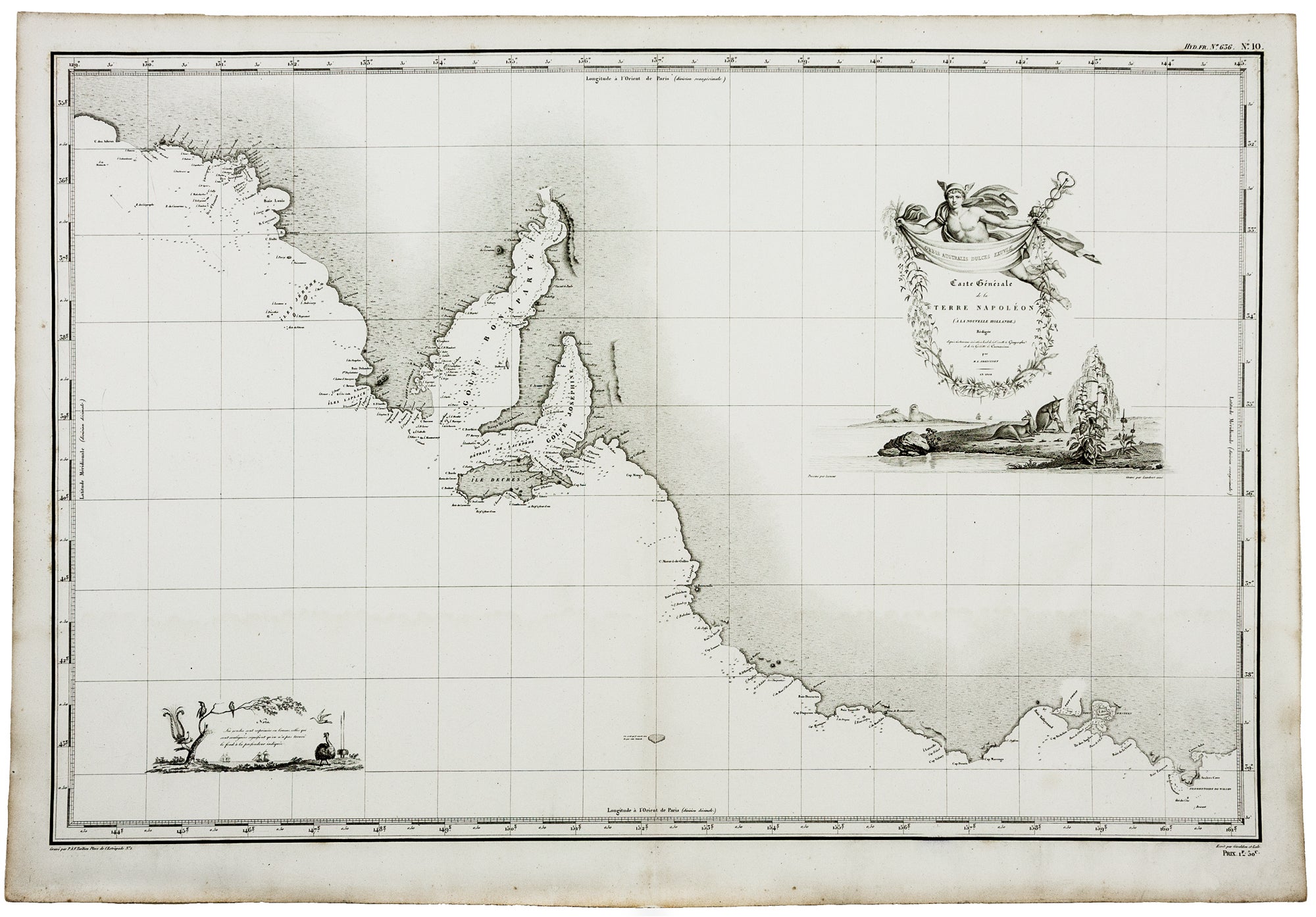
Carte Generale de la Terre Napoleon (a la Nouvelle Hollande)... par M.L. Freycinet an 1808.
19 x 29 1/2 inches;, A fine example.
The first detailed map of the Adelaide region (identified as B. Dugueselin, C. Sully and C. Mondovi), but also one of the most finely engraved early maps relating to Australia with delicate illustrations of kangaroos and other indigenous animals. The map centers on Kangaroo Island (Ile Decres) and extends east to Portland (Sealers Cove) and Cape Nelson State Park (Promontorie de Wilson) and west to the area of Nullarbor National Park. It was prepared by Louis Freycinet during his voyage under Captain Thomas Baudin in 1800-1803. When the first volume of Freycinet's voyage account was published in 1807, the authors claimed the south coast as a French discovery and named it Terre Napoléon. The English navigator Mathew Flinders who had explored the area previously was outraged by this as he had in fact charted the area first; he was further annoyed that his Spencer Gulf and Gulf St Vincent had been named after Napoléon and Josephine respectively, as shown on this map. In the title, the area covered by the map has been dubbed "Terre Napoleon."
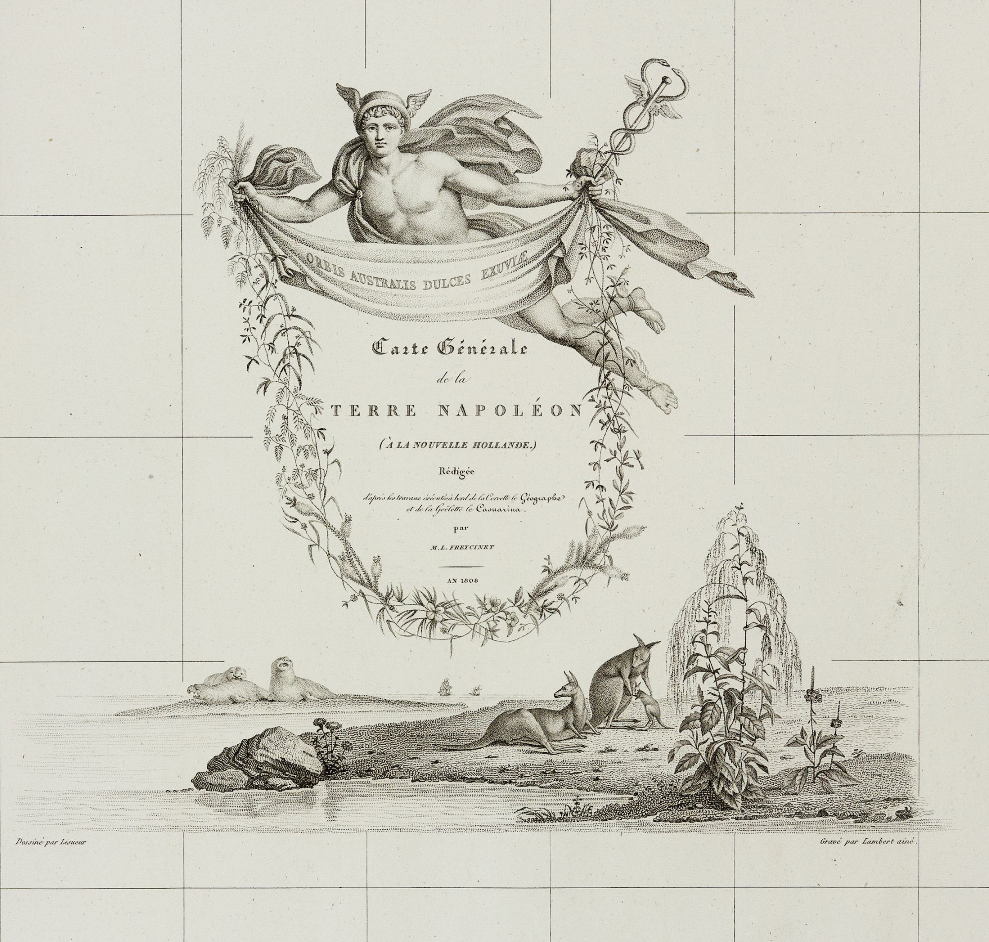
The map's cartouche was engraved with uncommon delicacy and illustrates three kangaroos, a group of walruses, and is elegantly surmounted by the figure of Mercury holding a banner and a garland of flowers surrounding the title. At the lower left surrounding a note, the ships, La Geographe and La Naturalist, which sailed on the French voyage, are illustrated along with indigenous flora and fauna. No fewer than five artisans' names appear on the map--the engravers P. A. F. Tardieu and Lambert aine, the artist of the larger cartouche, Lesuer, and two script engravers, Giraldon and Lale.
Although Matthew Flinders was the first to circumnavigate Australia in Her Majesty’s ship the Investigator between 1801-03, ironically it is the French who can lay claim to publishing the first complete map of the Australian continent. Freycinet’s map was published in France in 1811, three years before Flinders’ own chart, and appeared in the official account of the Baudin voyage. Baudin’s exploits in Australia commenced some seven months before Flinders arrived from Spithead in the Investigator. Rather than head for the uncharted southeast coast, Baudin instead sailed north up the west coast of Australia, occasionally landing at points previously uncharted by earlier 17th century Dutch navigators, and finally arriving at Timor. Meanwhile, Flinders had set out from Cape Leeuwin in an easterly direction with the intention of circumnavigating the continent. When Baudin eventually made it to the southern coast of Australia, Flinders had already charted a great deal of the previously uncharted southeastern coast. The two parties finally crossed paths at Encounter Bay (east of Adelaide) on April 8, 1802. Baudin had managed to chart only a small 200-mile section of the coast west of Wilson’s Promontory, the results of which are found on the present work. Although France at this time was at war with England, Flinders had been promised safe passage back to England. On his return, however, he was imprisoned by the French on Mauritius and held captive there for six and a half years. Meanwhile, the Baudin expedition had returned to France and the account of the voyage was published from 1807 and onwards by Peron. In 1810, Peron died, and Freycinet took over the task of completing the account. In 1811, Freycinet released the second part of the atlas, which contained the general chart of Australia. Flinders, on the other hand, had to wait until 1814 before he could publish his own general Australian map. As a further blow to Flinders, the Baudin / Freycinet map of Australia entirely ignored the English contribution to the charting of the southern coast. Fully aware of the discoveries made by Flinders and indeed of Grant in Bass Strait in 1800, the French instead used their own patriotic names on the map to replace those given by Flinders and Grant. Many of the place names were in fact given by Baudin.
* Tooley, Australia 611, pp. 82-83; cf. Clancy, R. Terra Australia, pp. 137-39.
Price: $4,850.00