
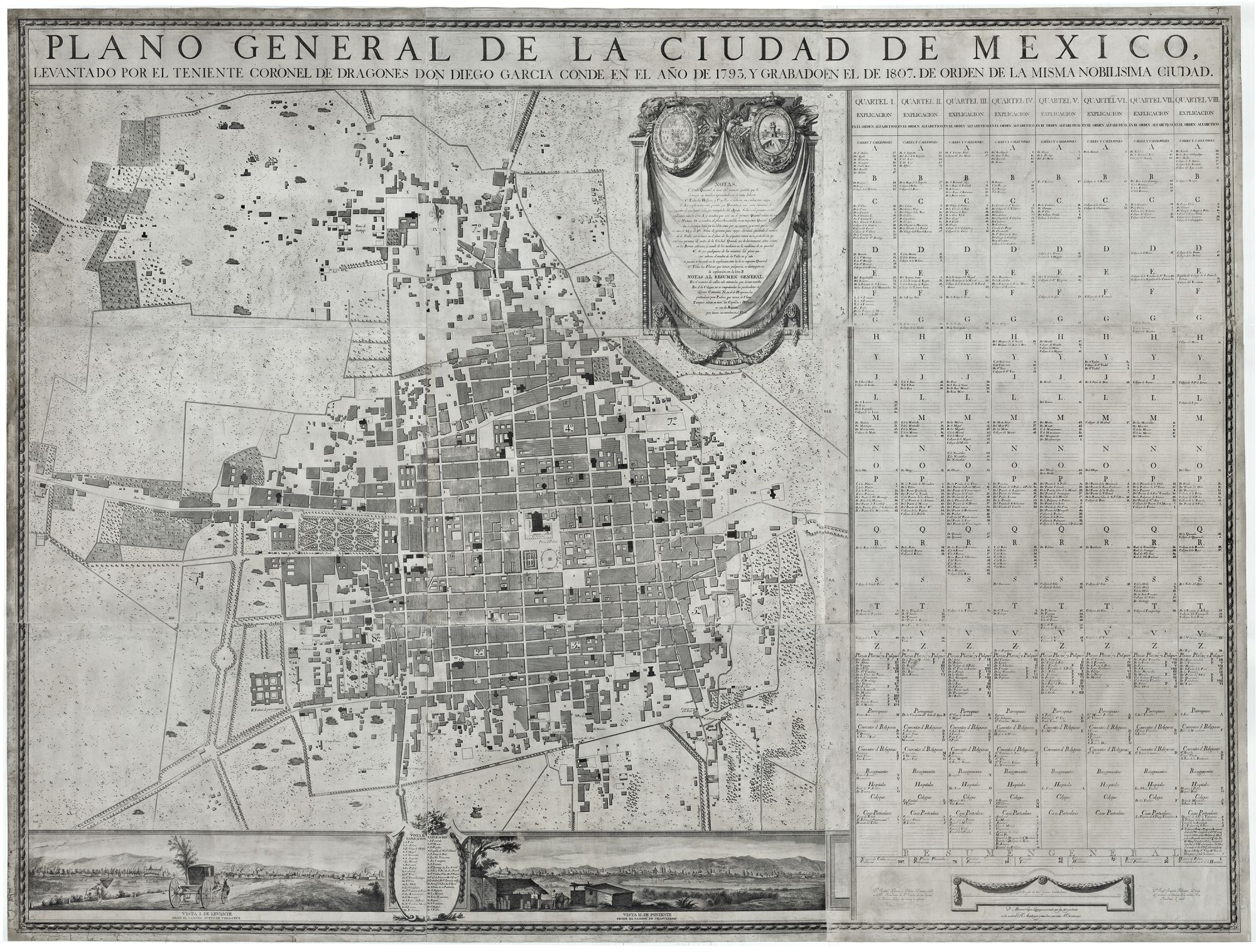
Plano General de Mexico levantado por el Teniente Coronel de Dragones Don Diego Garcia Conde en el año de 1793, y grabado en el año de 1807. De Orden de la misma Nobilísima Ciudad.
Oversize ornate cartouche at top, with drapery and architectural devices, medallions illustrating royal arms of Spain and Mexico City, text below. 2 vignettes at lower left: Vista I. De levante desde el camino Nuevo de Vera-Cruz and Vista II. DE Poniente desde el camino de Chapultepec ; between the views is a legend enclosed within botanical border, with locations keyed to numbers. At lower right: Dn. Rafael Ximeno y Planes, Director Gral. de la Rl. Academia de Sn. Cárlos de esta capital de México, dibujó las vistas y adornos. D Manuel López pensionado que fue del grabado en la misma R. Academia y tambien, por esta N C lo estampo. Dn. Josef Joaquín Fabregat, Director del grabado en lámina de la misma Real Academia, lo grabo. Large table in eight columns at right with streets and other features keyed to numbers and letters. Copper-engraved wall map on nine separate mounted sheets within restrained botanical border. Scale decorated with swags at lower right. 147.6 x 197.6 cm (58 x 77.8 inches, approximately 4 ½ x 6 ½ feet). Scale: One inch = approximately 100 Spanish varas. Expertly & sensitively conserved & re-mounted on new lines, minor losses & splits inconspicuously mended; in all, a fine example. Extremely rare, first and only printing in large format of the most important early plan of Mexico City and one of the most significant maps of any kind produced in Mexico. Two OCLC locations: BL & UC—Berkeley. We add the JCB. The plates for this map were destroyed and lost; the map was later republished in a much smaller format in London in 1811 and again in New York in 1830. An exceptionally handsome example. Diego Garcia Conde’s Plano general de la Ciudad de México is arguably the most ambitious cartographic undertaking in Mexican cartography to date. A map of great influence notable both for its exceptional scale and execution, it fixed the depiction of the city for decades to come. It dwarfed any previous depiction of the city produced in Mexico or elsewhere. The original surveys for the plan were conducted in 1793, during the viceregal administration of Conde de Revillagigedo. His administration, one of the most progressive of the colonial era, resulted in urban development and renewal that included the construction and the renovation of numerous public buildings and parks; improved sanitation, lighting, and security; the construction of roads and streets; and the establishment of professional schools (such as the Academy of San Carlos, where this map was produced). Given this wide-ranging development, there was a clear need for a sophisticated and accurate plan of Mexico City at the time. The creation of the Conde plan pooled the technical skills of three men of exceptional talent. The mapmaker was Diego García Conde (1760-1822), a native of Barcelona who came to Mexico and served as captain of the Spanish Dragoons in Mexico and fought the insurgents during the War of Independence. García Conde supervised several complex construction projects, including the road from Veracruz to Jalapa. In 1822 he was named director general of the Corps of Engineers and founded the Academy of Cadets. Dicc. Porrúa (p. 1156) specifically mentions the present map as one of his great achievements: “Su nombre está ligado a la historia de la cd. de México, por el magnífico plano que levantó de metrópoli in 1793.” The plan’s engraver was José Joaquín Fabregat (1748-1807), a native of Valencia. In 1787, the Spanish crown named Fabregat director of engraving at the Royal Academy of San Carlos in Mexico City. Here Fabreget instituted the highest standards for printing and engraving by introducing the most advanced techniques from Europe. The recognition of engraving as a valuable art, along with royal patronage, led to an unprecedented development of the art outside of Madrid. Among those participating in this flourishing era of engraving was Rafael Jimeno y Planés (1759-1825), the Valencia artist who created the exquisite vignettes at the lower section of this map. Jimeno y Planés studied in Rome, Madrid, and Mexico (Academy of San Carlos). In 1798 he became director of painting at the Academy of San Carlos in Mexico and, subsequently, Director General. Jimeno created the engravings for the 1780 edition of Don Quijote, the famous engraving of the Plaza Mayor de México (adapted by Humboldt), grand murals, and fine oil paintings. In both its accuracy, elegance and scale of its execution, the Conde plan signaled the coming of age of an indigenous Mexican cartography capable of rivaling what was being produced elsewhere in the world at the time.
*Instituto Mexicano del Seguro Social, El Territorio Mexicano II, p. 761 (illustrated). Lombardo, Atlas histórico de la ciudad de México, plate 144. Mathes, Illustration in Colonial Mexico: Woodcuts and Copper Engravings in New Spain, 1539-1821, Register 9989. Mayer, Poblaciones Mexicanos: Planos y panoramos siglos XVI al XIX, pp. 76-77 (illustrated). Museo Nacional de Historia Castillo de Chapultepec, Mapas y Planos de México Siglos XVI al XIX, p. 125. Palau 98695 (incorrectly ascribing the map to Pedro García Conde). Planos de la Ciudad de México 245. See Tooley, Dictionary of Mapmakers (2001 edition).
Price: $79,500.00