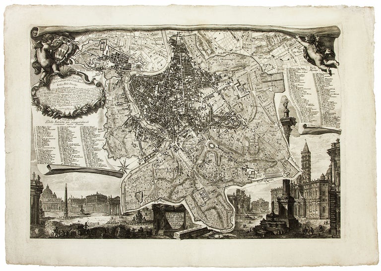
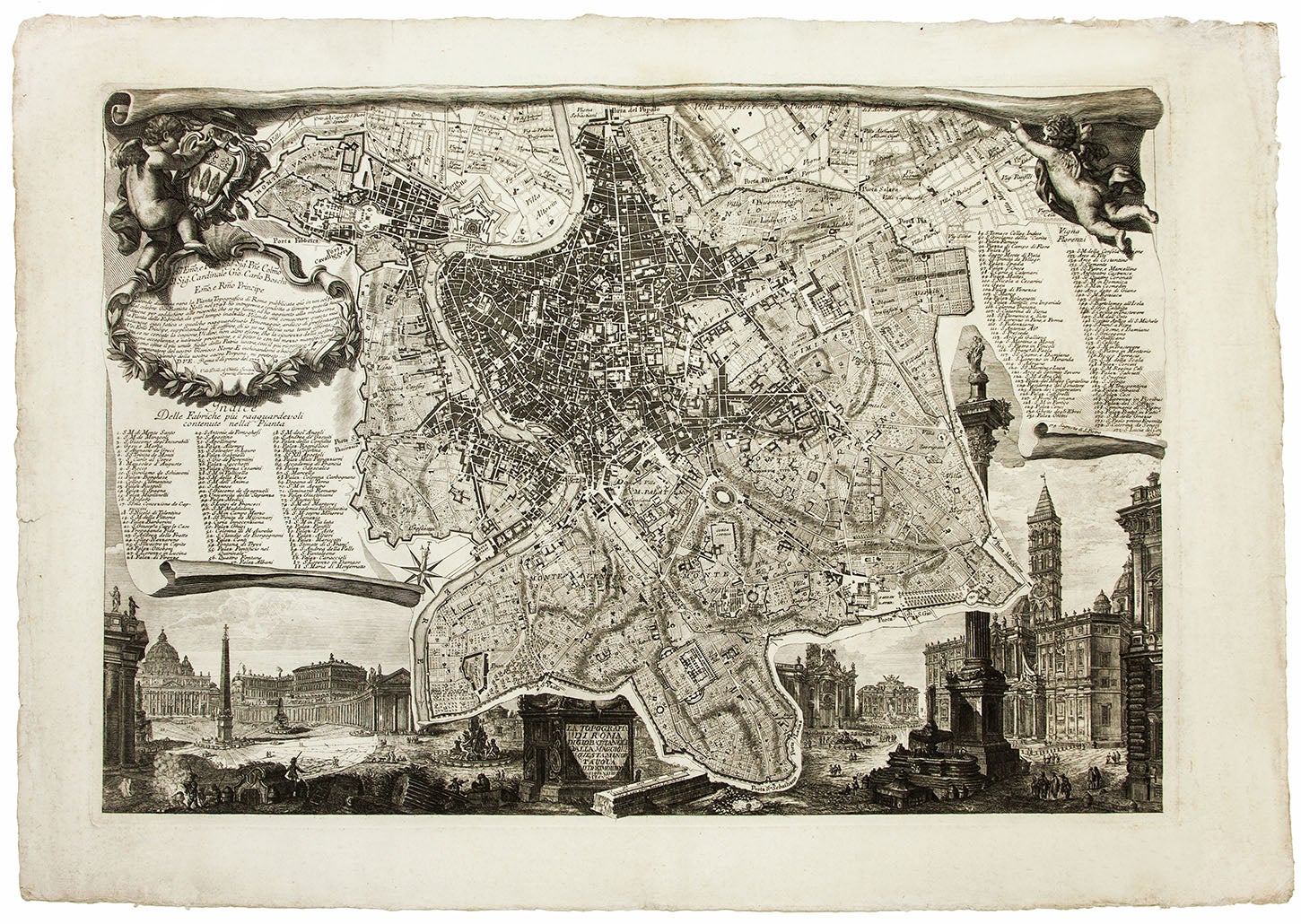
La topografia di Roma di Gio Bat(tis)ta Nol(l)i dalla maggiore in questa minor tavola del medesimo ridot(t)a e da Ignazio Benedetti incisa.
Folio [69.2 x 47.0 cm], single-sheet engraving. Only minor edge wear, a few minor marginal stains, a fine, boldly inked strike. Ignazio Benedetti’s rare 1773 updated edition of Giovanni Battista Nolli’s pianta piccola of Rome, the single-sheet engraved map Nolli released in 1748 as a reduction of his groundbreaking 12-sheet Nuova pianta di Roma. Nolli’s monumental plan was “accurate and exhaustive: a decisive turn toward modern urban cartography” (Maier, p. 17), but most viewers would have experienced Nolli’s revolutionary ichnography not in the form of a wall map or as 12 sheets bound up for careful consultation, but through the much more conveniently sized single-sheet pianta piccola. The popularity of Nolli’s smaller plan quickly led to its scarcity. In his dedication to Cardinal Giovanni Carlo Boschi (1715-88) on the present map, Benedetti notes that, “because the single-sheet topographical map of Rome published by the celebrated Giovanni Battista Nolli in 1748 has now become so rare, I produced this new edition to satisfy the demand, and I have added to the map structures built since that time.” Benedetti’s version of the pianta piccola is faithful to Nolli’s original, which surveys Rome within the Aurelian Walls by depicting the city plan in the visual conceit of an irregularly shaped banner (or sheet of parchment) held aloft by putti and fluttering in the wind. Beyond this fictive banner are seen atmospheric views of Piazza di San Pietro and Piazza di Santa Maria Maggiore, with smaller images of Santa Croce in Gerusalemme and the Fontana di Trevi visible in the distance. Benedetti carefully preserves Nolli’s syntax of varied engraved lines that signal distinct areas of built, uninhabited, ruined, public, and private urban spaces. As promised in his dedication, Benedetti adds a few recently completed buildings to the plan and to its key at the right. Benedetti added items 171 (San Paolo primo Eremita), 172 (S. Caterina dei Senesi), and 173 (S. Lucia del Gonfalone) to an early, very rare state of his plan (e.g., the Universitätsbibliothek Bern copy). The present example is the second state, which includes an additional item on both plan and key, number 174, the Sagrestia di S. Pietro, the name of which is engraved on the curled edge of the fictive banner/key; the new Sacristy of Saint Peter’s was built by Carlo Marchionni (1702-1786) between 1776 and 1784, suggesting a date of c. 1780s for this print. At some time thereafter, Benedetti’s copperplate passed into the hands of Venanzio Monaldini (1765-1819), who removed the text below the dedication to Cardinal Boschi and replaced it with the title Nuova pianta topografica della città di Roma and his address at Piazza di Spagna. A professional architect and surveyor, Nolli designed the gardens of the villa of Cardinal Albani as well as the Church of St Dorothea in Trastevere (1751). He came to Rome in the early 1730s and spent close to twelve years surveying and measuring the city’s monuments in preparation for his groundbreaking map. Little is known of Benedetti beyond his role in reissuing Nolli’s pianta piccola. OCLC locates U.S. examples of the first states of Benedetti’s plan (likely the 174-item version offered here) at Columbia and the University of Chicago. The later Monaldini state is to be found at the Getty and the Boston Athenaeum. *Frutaz, Le piante di Roma, vol. I, CLXIXb, p. 236; Scarafoni 234; Arrigoni/B. 176; J. Maier, Rome Measured and Imagined: Early Modern Maps of the Eternal City.
Price: $1,850.00