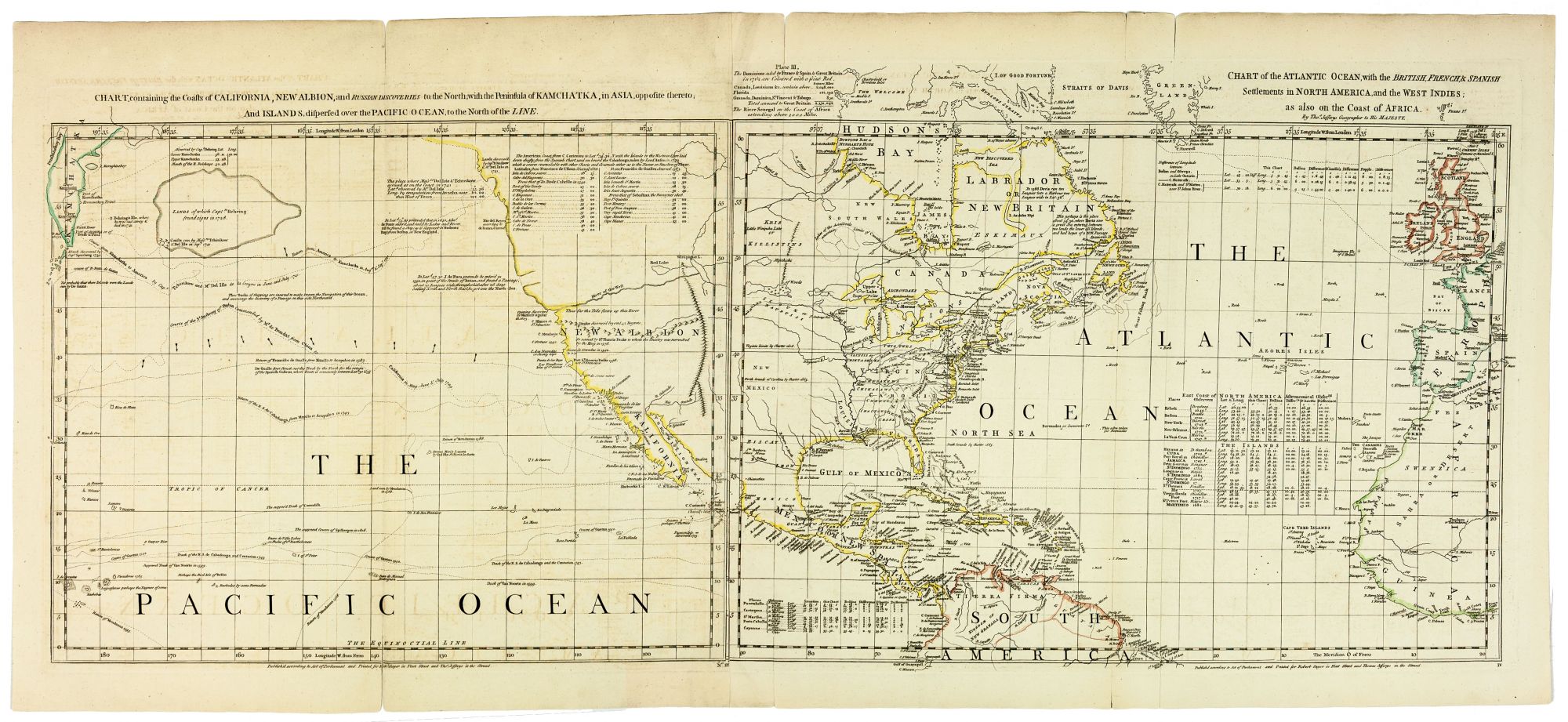
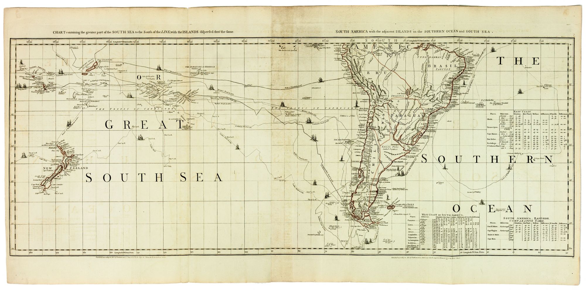
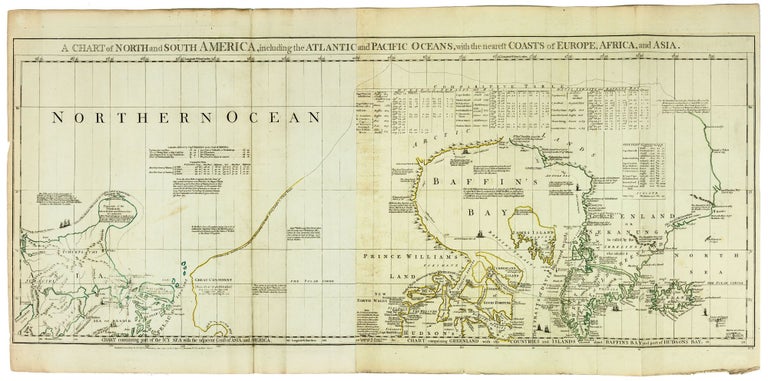
A Chart of North and South America, including the Atlantic and Pacific Oceans, with the nearest Coasts of Europe, Africa, and Asia.
Six sheets joined to make three panels, each approximately 18 x 44 inches. Original outline color; first sheet re-margined on right, overall excellent with wide margins. An unusual, large-scale, 18th-century map providing a striking visual record of a remarkable number of important exploratory voyages of both the Pacific and the Arctic undertaken between the 16th and 18th centuries. Published at the dawn of the great age of transoceanic exploration, Sayer & Bennett’s 6-sheet Chart is an essential item for understanding the state and progress of Pacific exploration and its impact on theoretical geography at the time. The map, drawn up by the (quite scandalous, see below) geographer John Green (born Bradock Mead, a.k.a ‘Rogers’), plots the important early voyages of this period, such as those of Anson, Bougainville, Wallis, Bering, Chirikov, as well as Cook’s first voyage. Also included are crucial earlier voyages, today both familiar and less familiar: Among the former are the voyages of Frobisher, Halley, Tasman, Baffin, and Hudson (his final and fatal one), and among the latter are 16th-century, trans-Pacific routes of Spanish galleons. While the graphic representation of select voyages on globes of the period was fairly standard practice, Sayer & Bennet’s massive 6 sheet chart is remarkable for being encyclopedic in scope and rich in commentary and scientific information too abundant to be legible on most floor and table globes of the period. * Stevens & Tree in Tooley, America, pp. 52-57, 4d; Wagner, Northwest, 649.
Not only does the map provide tracks of the above-mentioned voyages, but there are also numerous notations regarding specific places discovered. At numerous points along the track of Cook’s voyage, the degree of deviation from true north is noted. This map also provides a sound, corrective response to the flagrantly speculative mapping of the Pacific Northwest initiated by the Buache-Delisle map (1752), whose errors much angered Green.
This 1775 edition of the Sayer & Bennett Chart adds significant revisions to the 1753 first edition, perhaps most notably in the vicinity of Alaska, which is depicted here by a large island labeled Alaschka. The voyages plotted in Alaskan waters include those of “Three Russian Ships” (1648), Bering (1741), Chirikov with De L’Isle (1741), and Sindo (1764-1768). There are also important alterations to the Pacific, where the discoveries of Wallis, Bougainville, and Cook have modified the modified the previous mapping of Tahiti and New Zealand. The representation of the Falkland Islands in the South Atlantic have also been improved. The Solomon Islands, oddly, which on the 1553 edition of this map were labeled as being inhabited are labeled here as “Imaginary Isles.” Pepys Island, off the coast of Argentina, is also now described as imaginary.
The talented but troubled Dubliner John Green (born Bradock Mead) ranks as one of the most unusual figures in British cartographic history. Having narrowly escaped Dublin for his involvement in a kidnapping plo, he moved to London, where he was active in the map trade from the 1720s to about 1755, operating under various aliases. He committed suicide in 1757. Green compiled many of the maps for the prolific English cartographic publisher Thomas Jefferys (ca. 1719-1771), who was Geographer to Frederick Price of Wales and later to King George III. After Jeffreys died, his workshop passed to his partner, William Faden, whose bankruptcy in 1765 resulted in some of his copperplates being bought by Robert Sayer (1725-1794). In 1770 Sayer partnered with John Bennett, and it was this partnership that oversaw the editing and reprinting of this map.
Price: $5,500.00