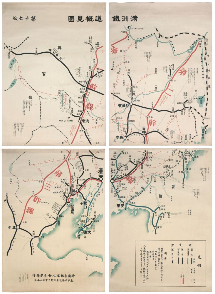
満洲鉄道概見図 / Manshūtetsudō gaikenzu.
4-sheet color lithograph map, each sheet measuring 110 x 79 cm; measuring 218 x 156 cm when joined. Unframed, un-joined. A bit dusty at extremities, a few minor mends at edges and some unobtrusive wrinkling. Color bright; generally very fresh. Very large, 4-sheet wall map, published for the Imperial Military Reserve Association, which presents a comprehensive (and graphically attractive) overview of the South Manchurian Railway (Mantetsu) as it stood in late 1931. Intended for ephemeral, official use and not as a decorative object, the map is remarkable for having survived both its original remit and the military social upheavals which followed in the years after its printing. Depicted in the bold red lines are the South Manchurian Railway’s three main/trunk lines, extending to all corners of the region, centered on the main city of Hōten 奉天 (Fengtian, now Shenyang). The black lines on the map show those railways originally constructed by the Chinese, which linked major commercial and industrial cities such as Harbin 哈爾浜, Changchun 長春, Dalian大連 and Beiping (北平, now Beijing, visible at the southwest corner of the map). Blue lines show the railways constructed by the Japanese, black-and-white lines show railways built by the Russians, and dotted lines are railways still under construction at the time of the map’s publication in December of 1931. Each railway line is annotated with information such as the date of completion, amounts of Japanese government loans, whether those loans were repaid, etc. The map was printed for the use of the Imperial Military Reserve Association. Established in 1910, the Imperial Military Reserve Association complemented the functions of the Japanese Army and Navy by facilitating ceremonial events, conducting military research, spreading military knowledge among civilians in the Japanese homeland, hence zaigō (lit. “in villages”) as opposed to in colonized territories in times of war. In 1931, the association had over 2,860,000 members, and by this time had become increasingly more influential as the de facto military organization that connected civilians to the official military establishment, assisting in mobilization and providing preliminary military training for Japanese youth. This war-room size map depicts the railway infrastructure at a tense moment in the political and military history of Northeast Asia. The three northeastern provinces of China, known as Manchuria, were the homeland of tribal peoples that occupied China at various periods beginning 1000 years ago. The Manchus ruled China during the Qing dynasty (1644-1912). Before the fall of the dynasty, Manchuria, like other regions of China, became the battleground for a variation on the ‘Great Game,’ fought between Russia and Japan. In the late 19th century, after gaining concessions from China, the Russians built the China Eastern Railway, connecting the Russian city of Chita to the port of Vladivostok, the eastern terminus of the Trans-Siberian Railway. In 1906, following the Japanese victory in the Russo-Japanese War (1904-05) Japan formed the South Manchurian Railway Company (SMR), known as Mantetsu, and built additional lines, primarily a trunk route from Changchun, later the capital of Manchuokuo, south to the Chinese port of Dalian (Jap. Dairen, Rus. Dalny). The war also resulted in Japan obtaining the Kuantung Leased Territory and the territories crossed by the SMR in southern Manchuria. 1906 also saw the establishment of the Kuantung Garrison, ostensibly to protect the railroad. The South Manchurian Railway Company was much more than an operator of passenger and freight lines. It provided an advanced network of social, economic and technical research institutes, hospitals, and schools, serving the needs of Japan’s industrial, agricultural (primarily exporting soybeans) and mining activities on the Chinese mainland. The SMR operated ports, engaged in steel and ceramics manufacturing, and built infrastructure to serve the needs of a rapidly growing population. For years, Mantetsu was the largest corporation in Japan. A number of complex factors – including the worldwide depression, warlord infighting in China, and indecision in Tokyo fostered by a series of short-lived prime ministers – came to a head in late 1931, when on 18 September the Kuantung Army, acting more or less independently of Tokyo, provoked a conflict with Chinese troops on the railroad. This event and the ensuing struggle are collectively known as the ‘Manchurian Incident.’ Six months later, on March 1, 1932, the Japanese army having overtaken Manchuria, the Japanese government announced the birth of Manchuokuo (Manzhouguo), a puppet state. * B. A. Elleman and S. Kotkon, eds., Manchurian Railways and the Opening of China.
This map was published on December 17, 1931, in the interim between the Manchurian Incident and the formation of Manchoukuo, after which the SMR took over the management of all railroads in the new state. In 1934, Puyi, the last emperor of the Qing dynasty, who abdicated in 1912, was placed on the throne of the Empire of Manchukuo. Soviet armies put an end to this empire in 1945.
Price: $6,850.00