![Item #5884 A general MAP of the MIDDLE BRITISH COLONIES, in AMERICA; Viz VIRGINIA, MÀRILAND, DÈLAWARE, PENSILVANIA, NEW-JERSEY, NEW-YORK, CONNECTICUT, and RHODE ISLAND: Of AQUANISHUONÎGY, the Country of the Confederate Indians; … By Lewis Evans. 1755. The upper left cartouche reads: To the Honourable Thomas Pownall Esq.r Permit me, Sir, to pay You this Tribute of Gratitude, for the great Assistance You have given me in this Map; and to assure the Public, that it has past the Examination of a Gentleman, whom I esteem the best Judge of it in America: Your most obedient, and most humble Servant, LEvans. Below this cartouche, text reads: Engraved by Ja.s Turner in Philadelphia. [Imprint:] Published according to Act of Parliament, by Lewis Evans, June 23.1755. and sold by R. Dodsley, in Pall-Mall, LONDON, & by the Author in PHILADELPHIA. [Bound with:] Geographical, Historical, Political, Philosophical and Mechanical ESSAYS. The FIRST, Containing An ANALYSIS Of a General MAP of the MIDDLE BRITISH COLONIES IN AMERICA; And of the Country of the Confederate Indians; A Description of the Face of the Contry;…By LEWIS EVANS. The second EDITION. PHILADELPHIA: Printed by B. FRANKLIN, and D. HALL. MDCCLV. And sold by J. and R. DODSLEY, in Pall-Mall, London. Lewis / FRANKLIN EVANS, James, Benjamin / TURNER, printer, engraver.](https://martayanlan.cdn.bibliopolis.com/pictures/5884.jpg?width=768&height=1000&fit=bounds&auto=webp&v=1580396984)
![A general MAP of the MIDDLE BRITISH COLONIES, in AMERICA; Viz VIRGINIA, MÀRILAND, DÈLAWARE, PENSILVANIA, NEW-JERSEY, NEW-YORK, CONNECTICUT, and RHODE ISLAND: Of AQUANISHUONÎGY, the Country of the Confederate Indians; … By Lewis Evans. 1755. The upper left cartouche reads: To the Honourable Thomas Pownall Esq.r Permit me, Sir, to pay You this Tribute of Gratitude, for the great Assistance You have given me in this Map; and to assure the Public, that it has past the Examination of a Gentleman, whom I esteem the best Judge of it in America: Your most obedient, and most humble Servant, LEvans. Below this cartouche, text reads: Engraved by Ja.s Turner in Philadelphia. [Imprint:] Published according to Act of Parliament, by Lewis Evans, June 23.1755. and sold by R. Dodsley, in Pall-Mall, LONDON, & by the Author in PHILADELPHIA. [Bound with:] Geographical, Historical, Political, Philosophical and Mechanical ESSAYS. The FIRST, Containing An ANALYSIS Of a General MAP of the MIDDLE BRITISH COLONIES IN AMERICA; And of the Country of the Confederate Indians; A Description of the Face of the Contry;…By LEWIS EVANS. The second EDITION. PHILADELPHIA: Printed by B. FRANKLIN, and D. HALL. MDCCLV. And sold by J. and R. DODSLEY, in Pall-Mall, London.](https://martayanlan.cdn.bibliopolis.com/pictures/5884_2.jpg?auto=webp&v=1580396984)
![A general MAP of the MIDDLE BRITISH COLONIES, in AMERICA; Viz VIRGINIA, MÀRILAND, DÈLAWARE, PENSILVANIA, NEW-JERSEY, NEW-YORK, CONNECTICUT, and RHODE ISLAND: Of AQUANISHUONÎGY, the Country of the Confederate Indians; … By Lewis Evans. 1755. The upper left cartouche reads: To the Honourable Thomas Pownall Esq.r Permit me, Sir, to pay You this Tribute of Gratitude, for the great Assistance You have given me in this Map; and to assure the Public, that it has past the Examination of a Gentleman, whom I esteem the best Judge of it in America: Your most obedient, and most humble Servant, LEvans. Below this cartouche, text reads: Engraved by Ja.s Turner in Philadelphia. [Imprint:] Published according to Act of Parliament, by Lewis Evans, June 23.1755. and sold by R. Dodsley, in Pall-Mall, LONDON, & by the Author in PHILADELPHIA. [Bound with:] Geographical, Historical, Political, Philosophical and Mechanical ESSAYS. The FIRST, Containing An ANALYSIS Of a General MAP of the MIDDLE BRITISH COLONIES IN AMERICA; And of the Country of the Confederate Indians; A Description of the Face of the Contry;…By LEWIS EVANS. The second EDITION. PHILADELPHIA: Printed by B. FRANKLIN, and D. HALL. MDCCLV. And sold by J. and R. DODSLEY, in Pall-Mall, London.](https://martayanlan.cdn.bibliopolis.com/pictures/5884_3.jpg?auto=webp&v=1580396984)
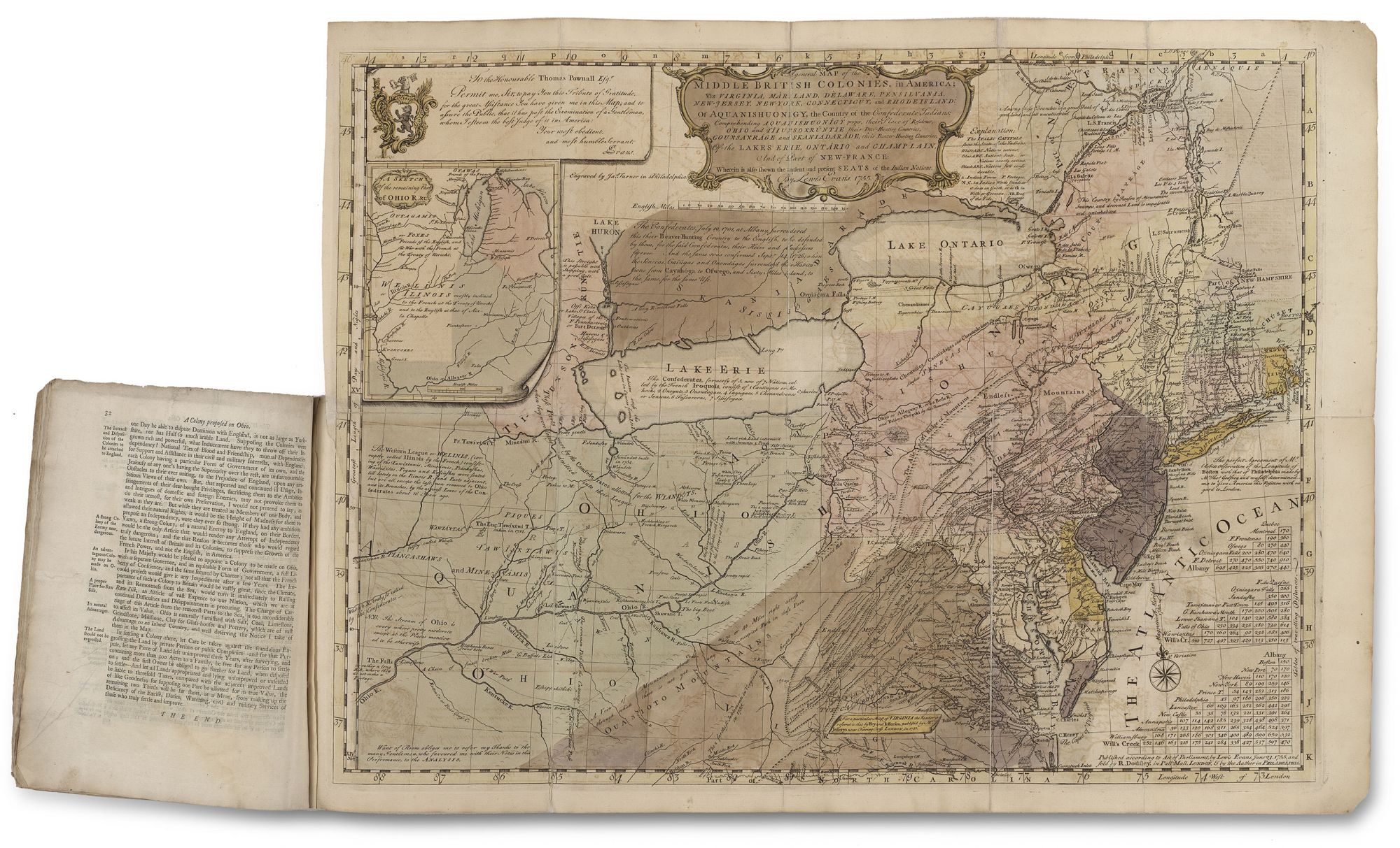
A general MAP of the MIDDLE BRITISH COLONIES, in AMERICA; Viz VIRGINIA, MÀRILAND, DÈLAWARE, PENSILVANIA, NEW-JERSEY, NEW-YORK, CONNECTICUT, and RHODE ISLAND: Of AQUANISHUONÎGY, the Country of the Confederate Indians; … By Lewis Evans. 1755. The upper left cartouche reads: To the Honourable Thomas Pownall Esq.r Permit me, Sir, to pay You this Tribute of Gratitude, for the great Assistance You have given me in this Map; and to assure the Public, that it has past the Examination of a Gentleman, whom I esteem the best Judge of it in America: Your most obedient, and most humble Servant, LEvans. Below this cartouche, text reads: Engraved by Ja.s Turner in Philadelphia. [Imprint:] Published according to Act of Parliament, by Lewis Evans, June 23.1755. and sold by R. Dodsley, in Pall-Mall, LONDON, & by the Author in PHILADELPHIA. [Bound with:] Geographical, Historical, Political, Philosophical and Mechanical ESSAYS. The FIRST, Containing An ANALYSIS Of a General MAP of the MIDDLE BRITISH COLONIES IN AMERICA; And of the Country of the Confederate Indians; A Description of the Face of the Contry;…By LEWIS EVANS. The second EDITION. PHILADELPHIA: Printed by B. FRANKLIN, and D. HALL. MDCCLV. And sold by J. and R. DODSLEY, in Pall-Mall, London.
Folding map in full original color, 21 x 27 1/8 inches, in original marbled-paper wrapper with “Evans Analysis of Map of The Middle British Colonies” in manuscript on front cover; moderate wear to covers. 2 blanks, 2 pl with title & preface, 1-32pp (small burn hole pp.19-20, result of candle dripping?) + folding map, splits at folds reinforced, else an excellent bright example in full original color. The very rare, first state (see below) of the first edition of a map called by Schwartz and Ehrenberg "the most ambitious performance of its kind undertaken in America up to that time” and by Stevens, “The Prototype… for the next half century.” Printed by Benjamin Franklin in Philadelphia, Evans map was a landmark in cartographic printing in North America, far exceeding in quality anything that had previously appeared. A contemporary advertisement for Evans map indicates that it was offered in two ways: one, on plain paper, uncolored, without the pamphlet describing it for a single piece of eight, and also at double this price for a colored copy on superfine paper, with the pamphlet. According to Sabin, most known copies of the map are uncolored. The present copy, however, is one of the finest known examples in full original color issued with the pamphlet. Evans’ map was the first to delineate with any degree of accuracy the lands of the then frontier beyond the Appalachian Mountains and, in particular, the Ohio Country that would be contested in the French and Indian War that began a year after its publication. With this work, indigenous American cartography took the lead in the mapping of its own backyard; no previous American map was accomplished with such skill, intimate knowledge of its subject, and as influential. Many compared Evans’ map favorably to the monumental Map of the British and French Dominions in North America, recently completed by Virginia physician John Mitchell. Benjamin Franklin, for example, wrote that “When [Evans’ map] is done, Dr. Mitchel’s Map may perhaps be something improv’d from it.” (Degrees of Latitude, p. 174). Nearly 20 editions of it would follow -- most of them pirated by English publishers. George Washington was well-acquainted with Evans’ map and said of it: “’Evans, in his map and analysis of the middle colonies which (considering the early period at which they were given to the public) are done with amazing exactness’” (Schecter, p. 212). Moreover, immediately upon the map’s publication in 1755, General Edward Braddock used it in his failed campaign to take the French stronghold Fort Duquesne (Pittsburgh as of 1758) in the summer of 1755, at the beginning of the French and Indian War. In much of the accompanying pamphlet, Evans discusses the specific surveys underlying his map and the geography from earlier maps which he incorporated into his own. He drew from the experience of traders and native Americans when available. His knowledge of native tribes--their territories, locations, strengths, affiliations, and degrees of friendliness toward both the British and French--is remarkably well-documented. He displays a clear understanding of the difference between native American and European conceptions of property and foresaw the crucial role to be played by native Americans in the coming war. Evans’ on the ground knowledge of the Ohio Valley is extensive and his discussions of water courses that connect the eastern colonies with the frontier were highly useful. As water was the primary medium of transport connecting the colonies with the frontier, Evans takes great pains to assess the available routes, both for the purpose of their use in the coming war and in the course of future development. His map is considered by some to be the first geological map of the United States, and specifically the first to provide the location of oil in the country. Evans not only describes geography but also geomorphology (particularly regarding the formation of the Appalachian range) and other natural features of the region. Evans was a highly talented surveyor and mapmaker. Pritchard and Taliaferro describe him as “the best geographer working in the English colonies in the mid-eighteenth century.” Of Welsh extraction Evans (c. 1700-1756) arrived in the colonies in the 1730’s settling in Philadelphia. He soon befriended Benjamin Franklin, with whom he shared many interests. Franklin was this work’s printer and likely responsible for securing the services of the Boston engraver, James Turner, who Franklin knew. A dedicated scientist, Evans corresponded with a(c. 1700-1756) number of the leading scientists and mapmakers of the day including Peter Collinson, and Cadwallader Colden. Thomas Pownall, who would become the governor of the Massachusetts colony and was an avid and sympathetic observer of America, helped Evans in financing his map. In the pamphlet accompanying it, Evans warmly refers to Pownall as the source of the some of the map’s underlying surveys, and the map is dedicated to him. Following its publication, Evans issued a provocative pamphlet, which hinted at a treasonous collusion with France by Governor Robert Hunter Morris of Pennsylvania, for which Evans was imprisoned in New York, where he had re-located. He was released from jail only three days before he died in 1756, leaving his motherless eleven-year-old daughter in the care of friends. Pownall would in 1776 produce the only authorized later edition of Evans’s map, the profits from which he promised to Evans’s orphaned daughter. The first state of Evans’ map, offered here, is distinguishable by the absence of “The Lakes Cataraqui” above Lake Ontario. “There were two issues of the text printed at Philadelphia in 1755 which are identical except that some copies, intended for Sale in England (as was this copy) have the added line on the title page, ‘And sold by R. and J. Dodsley, in Pall-Mall, London’” – Streeter II., 819. Provenance: Private Collection (2019); Museum Books Store, Cat. 8, no. 402, 22.10 pounds, Nov. 1905. This item is owned in partnership with Boston Rare Maps and Robert Augustyn Rare Maps.
Price: $225,000.00