
Ein begründter und verständiger Bericht von dem Feldmessen wie man Aecker, Wisen, Gärten, Höltzer, Weyer, und andere Grundstuck….
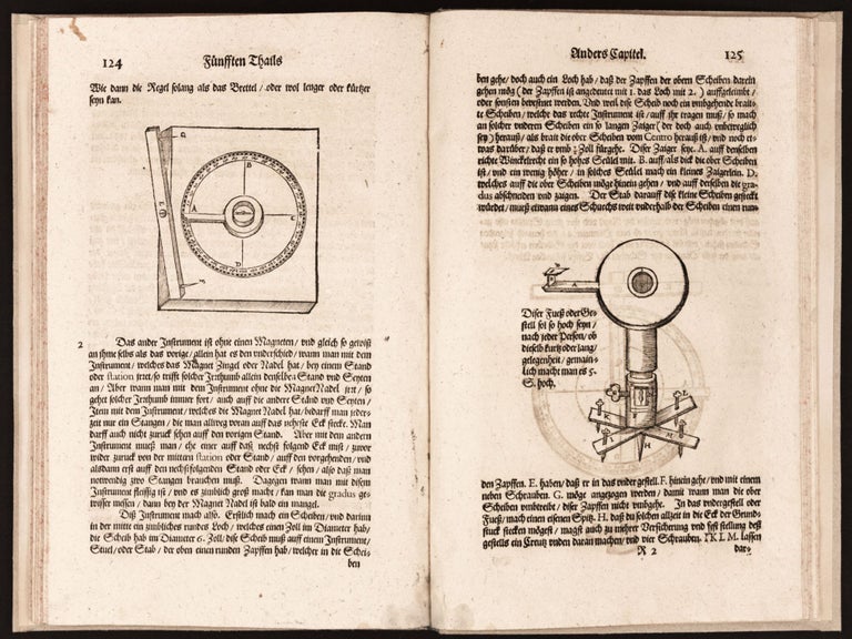
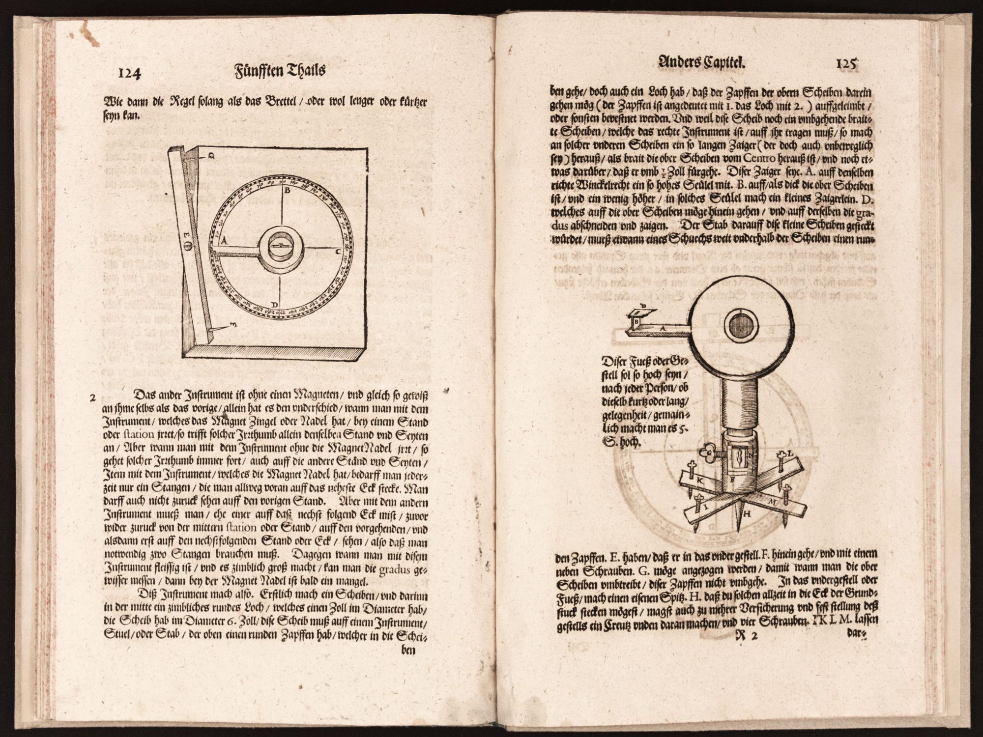
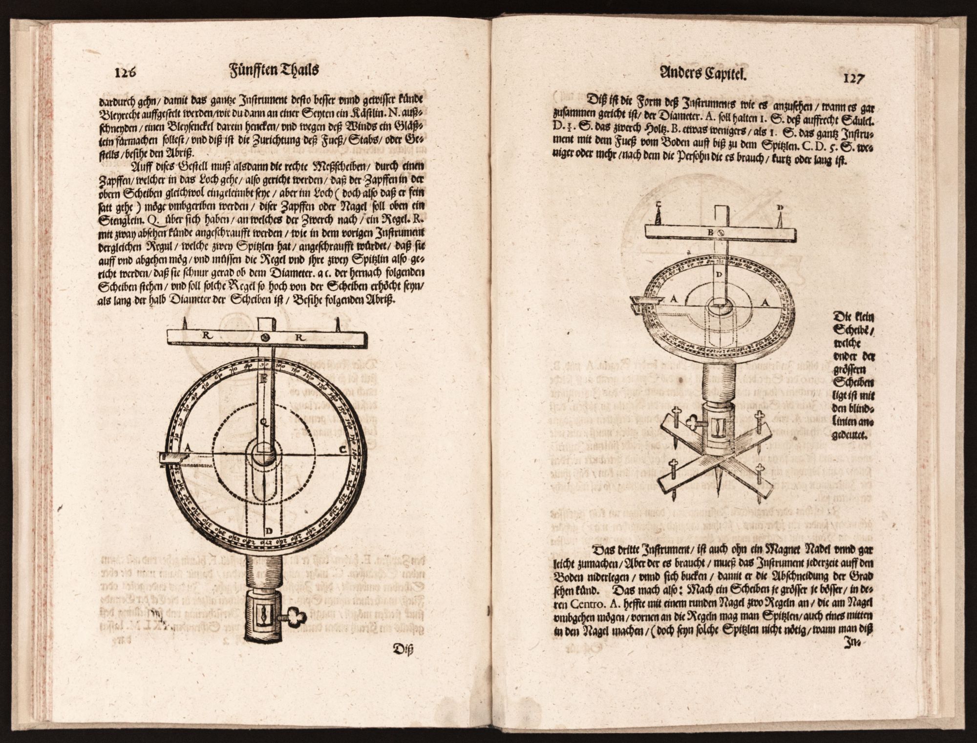
Folio [32.0 x 20.5 cm], (3) ff., 154 pp., (2) ff., (1) folding table, with numerous woodcuts in the text, woodcut printer’s device on title, initials, headpiece and tailpieces. Bound antique-style cartonato, red sprinkled edges. Occasional minor marginal dampstaining, the occasional minor stain, mends to two holes in title page (cancelled inscriptions?) not affecting text, a few contemporary annotations. Rare, anonymously authored German-language treatise on the art of surveying, first published in 1616, with copious practical information on measuring any type of terrain. Extensively illustrated with more than 100 woodcut geometrical diagrams and woodcut images of surveying instruments, the work shares much in common with the popular German manuals on the subject by Erasmus Reinhold (1511-53), Bernhard Cantzler (b. circa 1566), and Abdias Trew (1597-1669). The Geometrei (1498) of Jacob Köbel of Oppenheim (1462-1533) is cited in the preface as an early vernacular forebear, and the influential Geometica practica (1604) by Christoper Clavius (1537-1612) is referred to as a guiding Latin text. The author notes that his manual – a practical treatise in the mode of the Roman agrimensores – is especially written for the region of Bayern, which had a dearth of well-trained surveyors needed for facilitating the buying and selling of land and for providing information on private and civic boundary disputes. After providing fundamentals on basic concepts of arithmetic, linear measurement, surface measurement, and other relevant types if applied geometry (in the tradition of longimetria, altimetria, profundimetria, gaeodosia, ichnographia), the work discusses and illustrates right-angle sights as well as devices with more complex moveable sights. The treatise “is interesting in that it mixes some complex survey examples with simple illustrations and examples of instruments like the Jacob’s Staff” (Tomash, p. 1256). * Bilder-Chronik der Königlichen haupt- un Residenzstadt München, p. 55; Kat. Der Bib. der Königlichen Technischen Hochschule, p. 130. E. Tomash & M. R. Williams, The Erwin Tomash Library on the History of Computing: An Annotated and Illustrated Catalogue, vol. III, pp. 1255-66, no. S 216 (the 1616 ed.).
OCLC locates this 1665 surveying manual at Harvard, Smithsonian, Getty, Columbia, and Birmingham-Jefferson Public Library (no copies of the 1616 or 1617 editions are recorded in U.S. public libraries).
Price: $2,850.00