
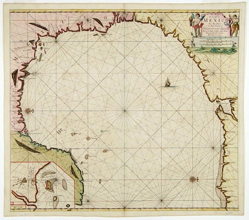
Pas Kaart Van de Golff van Mexico.
20 1/4 x 23 inches, Fine hand color; fine example on heavy paper. A fine, beautifully colored example. “The first sea chart of the western portion of the Gulf of Mexico detailing the coastal waters of present-day Florida, Alabama, Mississippi, Louisiana and Texas” (Burden). This attractively engraved work is oriented with north to the right, and it was evidently based on Spanish manuscripts, as its place names are for the most part still in Spanish. Martin and Martin describe the Van Keulen sea atlas, the Zee-Fakkel, in which this chart appeared, as a "work [that] was immediately recognized as superior to anything else on the market and [which] enjoyed a considerable reputation for accuracy and detail." The Van Keulen firm had unprecedented longevity for a map publishing concern; it was in operation for over two centuries from 1678 to 1885. Martin & Martin, Maps of Texas and the Southwest, plate 11, pp. 84-5; Burden 592, state 2.
Sold