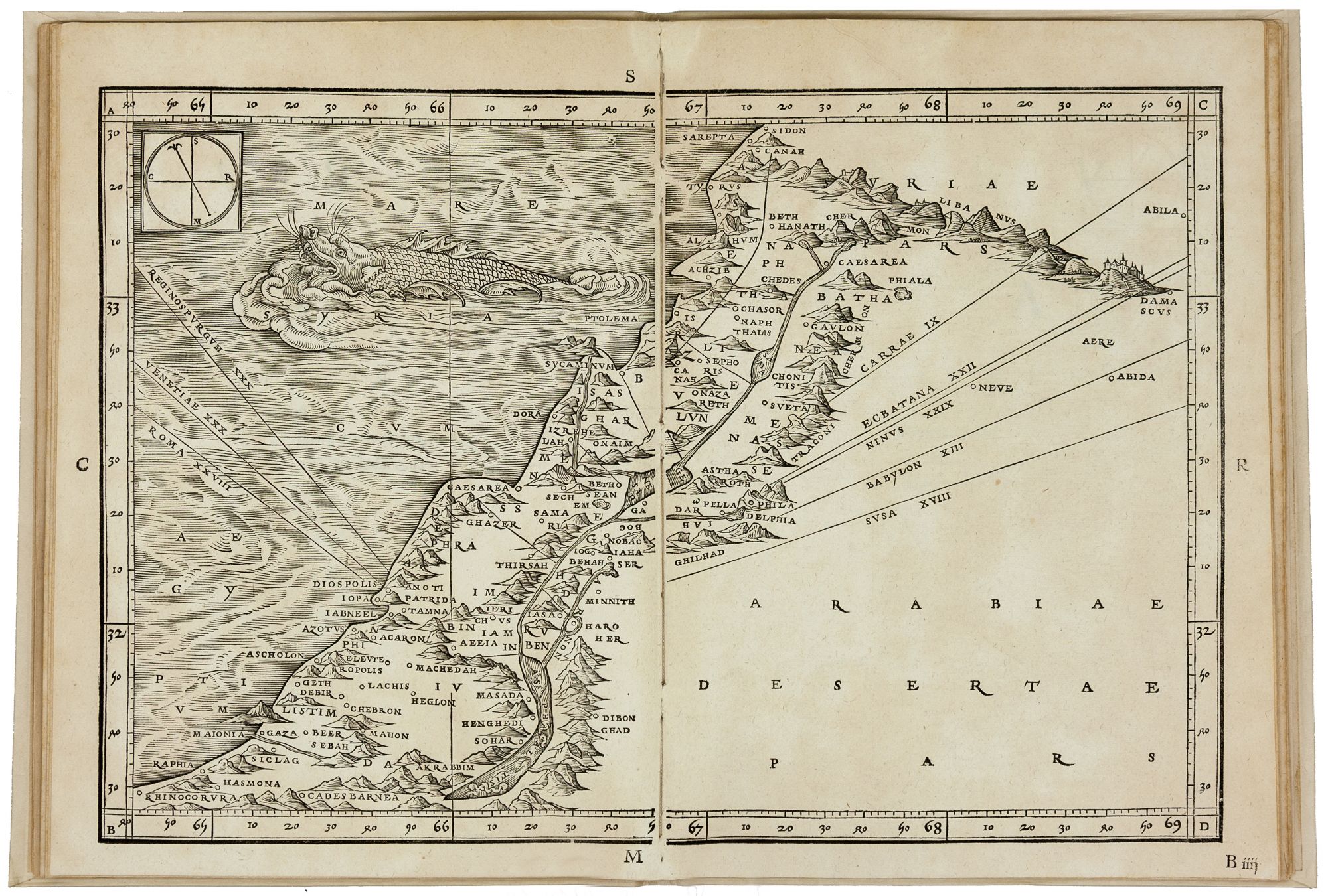

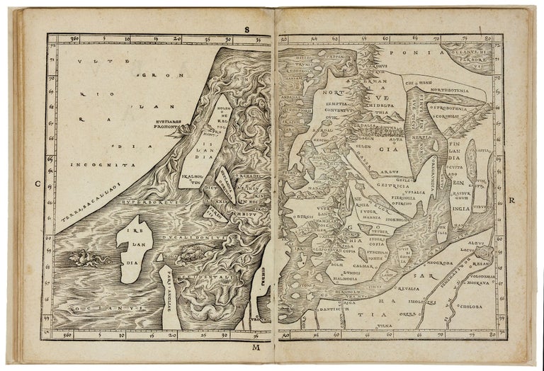
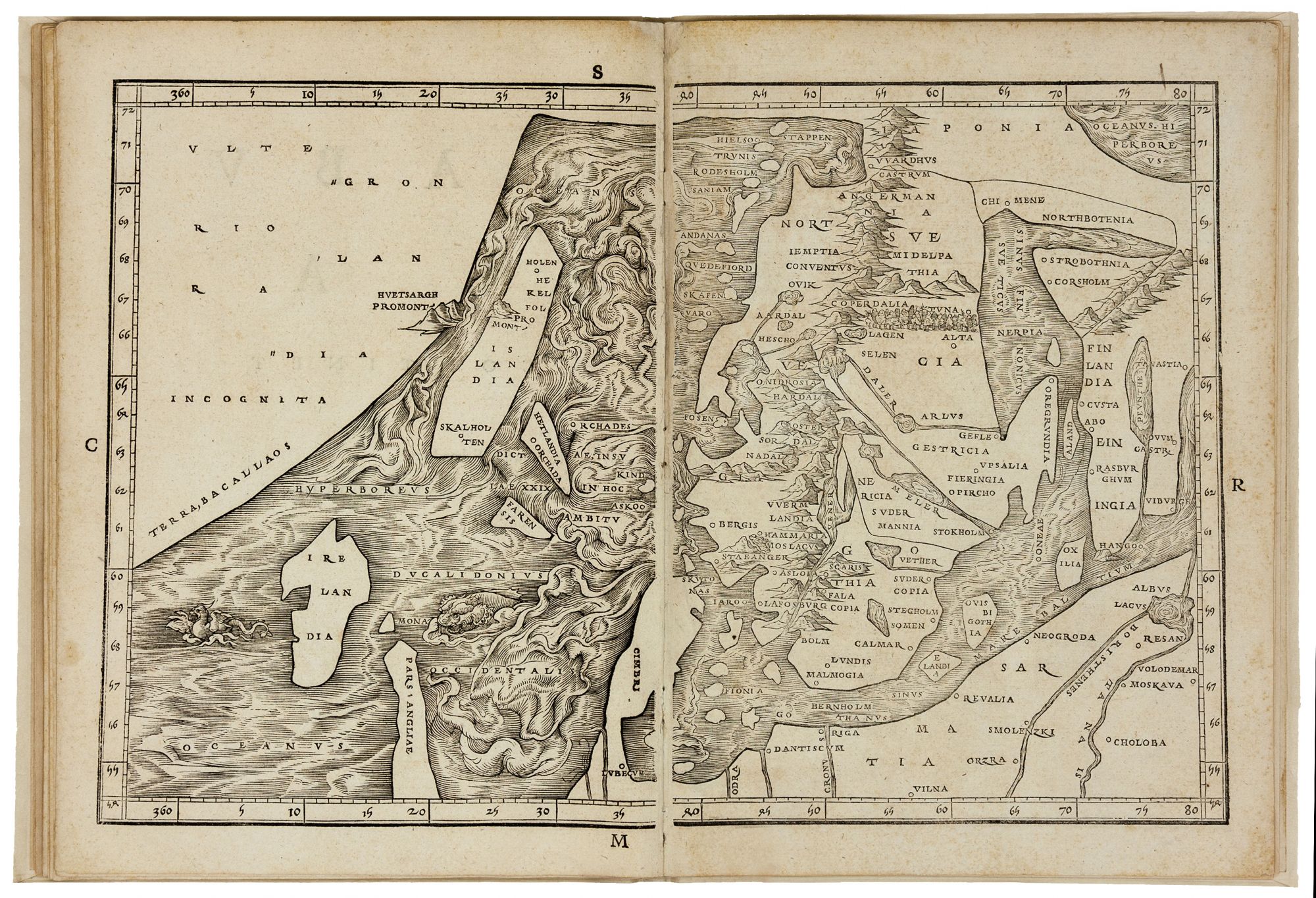
The Complete Suite of Eight sequentially numbered double-page woodcut maps of the Eastern Mediterranean and Scandinavia from Ziegler’s Quae intus continentur ….
Each map printed from 2 woodblocks. Bound in later vellum. Scarce first edition of the complete suite of 8 maps illustrating Ziegler’s highly influential attempt at a scientific mapping of the Holy Land, representing the first atlas devoted to that region (Nebenzahl, p. 10). The work also contains (map 8) the first map of Scandinavia not to be entirely derived from Ptolemy’s geography and regarded as the first new map of the northern regions since the Ulm Ptolemy of 1482, printed 50 years earlier. This map includes an enormous continent (Greenland), the southernmost portion of which is labelled “Terra Bacallaos,” the ‘Land of Codfish’ – likely referring to early fishing activities off the coast of Newfoundland. “Although new astronomical measurements were unavailable, [Ziegler] tried to base his data on at least two different parallel sources and to remove or revise geographical information he thought to be incorrect…. Although firmly based on the geographical work of Ptolemy, Ziegler’s cartography is thus more refined than his contemporaries; he takes the unusual step, for example, of displaying the distances from major European cities (Rome, Venice, Regensburg) on his map of Jerusalem. Ziegler was also one of the first to depict magnetic declination in his maps, illustrating the difference between true and magnetic polar directions. According to Tishby, his novel map of Palestine included here “influenced a number of major cartographers, among them Gerardus Mercator (in his first map of the Holy Land in 1537), Sebastian Muenster, and Tilemannus Stella in 1559”(Tishby, Holy Land in Maps, p. 86). Ziegler’s cartography had a direct influence on numerous early mapmakers, including Schoener, on his globe of 1533, Mercator on his 1537 world map, Muenster on his 1540 map of Scandinavia and Gastaldi 1548 map of the same region. Ziegler had access to information from the voyages of John Cabot and the writings of Peter Martyr, as well as geographical sources from Scandinavian Prelates at the Papal court whom he met in Rome, including Johannes and Olaus Magnus. Ziegler’s sources for his printed description of the Middle East include Josephus Flavius, Eusebius, Hieronymus, Strabo, and Pliny. But he was also clearly aware of more modern intelligence concerning the region, drawing on Burchard’s description of Mount Sion and the 15th-century travel accounts of Bernhard von Breydenbach. Jacob Ziegler (ca 1470-1549), was a theologian, historian, mathematician, and geographer. He was educated at Ingolstadt where he came into contact with some of the greatest minds of the day, including Conrad Celtis, the discover of the Peutinger map, and the mathematicians and astronomers Johan Stabius, and George Tanstetter. In 1504 he published his first cartographic treatise, on the mathematics of map-making. In 1525, he moved to Ferrara near his friend Celio Calcagnini where he worked on his manuscript of the present work which he dedicated to Duchess Renata of Ferrara, the daughter of Louis XII of France. Like Ziegler himself, the Duchess was a notable convert to Protestantism and friend of Calvin. Due to Ziegler’s conversion his works were placed on the Index in the 16th century. * Burden 9; Ginsberg, Septentrionalium Regnum, map 9. Nordenskiöld, pp. 60-1. Laor, Maps of the Holy Land 866-70; Nebenzahl, Maps of the Holy Land pp 70-1; cf Tishby, Holy Land in Maps, pp 86-7; Alden/Landis 532/26 (Greenland); Karrow, Mapmakers of the Sixteenth Century, pp.603-11.