Untitled.
28 x 41 inches, Few mended splits at left just entering surface, else a fine, bright example.
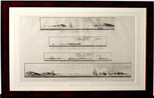
Profile Recognition Views of Boston Harbor. [London, October 7, 1777] 1. Boston, seen between Castle Williams and Governor’s Island, distant 4 miles. 2. Appearance of the High Lands of Agameticus, N.E. with Penobscot Hills, to the Eastwards, at 3 to 4 Leagues off Shore. 3. Boston Bay, the Light House bearing N.W.b.W distant one League. 4. The Entrance of Boston Harbor. 21 ½ x 31 inches. Fine condition.
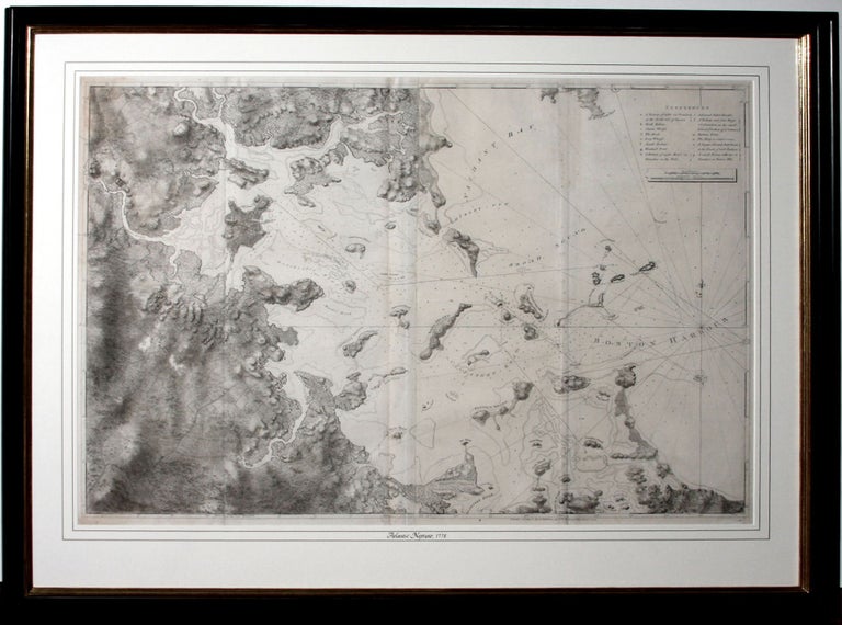
A beautiful example of the first state of Des Barres’ magnificent chart of Boston Harbor, which at the time of the American Revolution and 50 years thereafter was the most accurate chart available of the crucial port. Its combination of accuracy and visual appeal has never been surpassed. It was specifically prepared for use by the British Navy during the Revolution and includes much military information, such as forts and various emplacements.
The chart depicts Boston Harbor and much of the coastline between Nahant and Hull. Extensive soundings are given as well as numerous navigational aids and hazards. It also provides a surprising amount of terrestrial detail not available on any other printed map of the time, including bodies of water, roads, structures, and even the boundaries of fields. Elevations and slopes are shown by subtle variations in the etched shading. An alphabetical key identifies fourteen locations in Boston proper, including batteries and forts, wharves, and the Charlestown ferry. Indeed, this first state of the chart includes more detail than later states, with the “Mistic River,” “Maldon River,” “Road to Salem and Marblehead,” “Cambridge” named. According to Stevens, these and other place names were for some reason erased from later states.
Complementing the chart are four, very fine aquatint views displaying what the mariner could expect to see at key points in navigating Boston Harbor. Though of delicate beauty, they served a vital purpose. Nautical charts and atlases such as the Neptune often included profile views of important and/or problematic coastlines. These views provided a secondary data source to back up a navigator’s calculations and ensure a safe approach to land. When bad weather made astronomical observations impossible and placed a ship’s location in doubt, such views could be invaluable. These views of Boston were particularly important because the approach to the town is complicated by numerous islands, shoals and rocks, with the Inner Harbor accessible only by a narrow channel between Castle William and Governors Island. The larger top and bottom views, which respectively depict the approach to the city itself and the entrance of the harbor, were executed at a level of artistry far beyond their utilitarian function; the ships, light houses and land formations are all drawn with exquisite detail. Des Barres was actually the first publisher in England to make extensive use aquatint, an intaglio process in which acid is used to bite the plate around a ground consisting of fine resin particles. When well-executed, as in these views, the effect is similar to that of a watercolor wash. Interestingly, in the view of the entrance of Boston Harbor, an incompletely engraved sketch of a sloop can be seen in the foreground, inadvertently illustrating the process of composition and engraving involved in producing these images.
This chart and sheet of views was published in Des Barres' magisterial atlas, The Atlantic Neptune, first published in 1775 and thereafter periodically until the end of the century. It was funded by the British government, itself an unusual circumstance in the production of maps in England to that date, for the use of the British Navy in America during the Revolution. Judging by the result, clearly no expense was spared in its creation; it has been described as “the most splendid collection of charts, plans, and views ever published.” (Rich, Bibliotheca Americana).
* Boston Engineering Department, List of Maps of Boston, pp. 70-71; Krieger and Cobb, Mapping Boston, p. 106, plate 19; Parke-Bernet Galleries, The Celebrated Collection of Americana formed by the Late Thomas Winthrop Streeter, vol. 2 lot 706; Stevens, Catalog of the Henry Newton Stevens Collection of the Atlantic Neptune, pp. 211-216
Sold