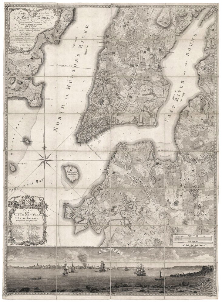
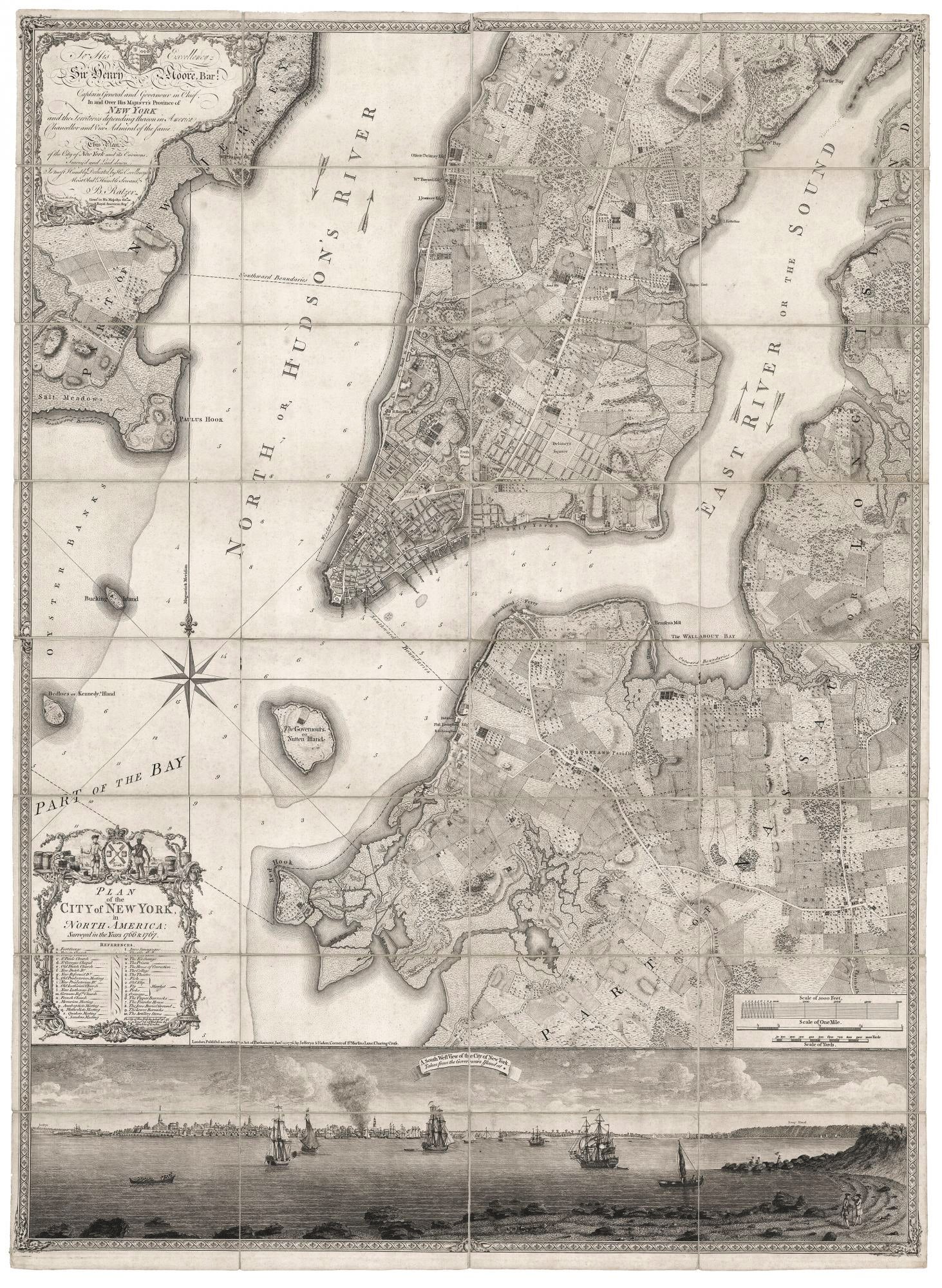
Plan of the City of New York, in North America: Surveyed in the Years 1766 & 1767.
Three joined sheets, totaling 46 ¼ x 34 5/8 inches, dissected & mounted on linen as originally issued. Some light discoloration but overall excellent with ample margins. Archivally framed. Rare; a superb example of the best executed and most beautiful, printed map one can acquire of early New York, and arguably also the masterpiece of 18th-century urban cartography of an American city. In addition to a plan of the city itself, the work provides a remarkable evocation of the pre-development landscape of Manhattan that consisted of cultivated fields, estates, water courses, topographic features and roads. These are supplemented by a highly realistic and detailed view of the city as seen from Governor’s Island. Also, significant portions of today’s Brooklyn and Queens and a small part of New Jersey are similarly depicted; such detail for these areas was not seen prior to this map. The map extends as far north as present-day 50th street, but the city itself at the time was almost entirely still below Canal Street. It reveals that in the area above the city proper the landscape was a mix of farmland, undeveloped forest and salt meadow, all interspersed with fine estates of the city’s well-to-do. Notable are the clusters of estates that would eventually become Greenwich Village; the estate of Captain Thomas Clarke called Chelsea, after which the today’s west side neighborhood is named; and the estate of Robert Murray, from which today's Murray Hill developed. These estates suggest that real estate was the prime repository for wealth at the time. In contrast, the landscapes of what is now Brooklyn and Queens as shown on the map are more purely agrarian. The map also reveals much about the original topography of Manhattan and vicinity, which consisted of several, disparate micro eco systems. The work depicts a more undulating landscape than we have been left with today, one that was intersected by numerous streams and rivers and with several bodies of water, all of which are depicted on the map. The largest of these can be seen at the northern border of the town proper and is here called the “Fresh Water.” Also called the Collect Pond, it was a 10-acre lake, which, as the Ratzer map shows, was already being filled in at the time. By the beginning of the 19th century, it had disappeared. The view at the bottom, like the map itself, is a highly accomplished work. Although the city is depicted from quite a distance, its still provides a richly realistic portrait of the colonial skyline. Also, the considerable foreground allowed the artist the opportunity to capture a sense of tranquility and ease, which were no doubt part of the reality of this thriving British colony prior to the Revolution. Two gentlemen converse along Governor’s Island’s rocky shore; another fishes off a promontory with a companion, and there is a woman with a parasol behind them; and in a long boat cadets seem to be receiving instruction. The large billow of smoke coming from the town just left of center was at one time thought to be part of the great fire that destroyed a large part of the city in 1776 (since all but two copies of the map are dated 1776). However, if one looks closely, one can see a careened ship and the smoke emanating from a cauldron, which would contain the heating tar used for caulking the vessel. The map is largely based on surveys made by Bernard Ratzer in 1766 and 1767, which continued the work begun by John Montresor in 1765. In comparing this work with Montresor’s plan, one can see there was significant new development in the short interval between them. Most notable is a sizable grid of streets surrounding an area called Delancey Square in what is now the Lower East Side. Ratzer’s map was initially published by Thomas Kitchin in 1770, but only three or four examples of this edition are known. The only other edition is this one of 1776, jointly published by Jefferys and Faden. Bernard Ratzer was a military engineer who came to America during the French and Indian War and worked throughout the Northeast and was made captain in 1773. In 1769, perhaps as an extension of his work for this map, he surveyed the official border between the then colonies of New York and New Jersey. On the same day this work was published, Ratzer published a plan that focused on the city of New York itself, depicting it at a slightly earlier point in its development than here. It is called the Ratzen plan due to the misspelling of Ratzer’s name on it. Augustyn/ Cohen, Manhattan in Maps, pp. 73-77; Schwartz/ Ehrenberg, p. 192; Pritchard/ Taliaferro, Degrees of Latitude, no. 46; Deak, Picturing America, no. 121.