
Totius Orbis Cogniti Universalis Descriptio.
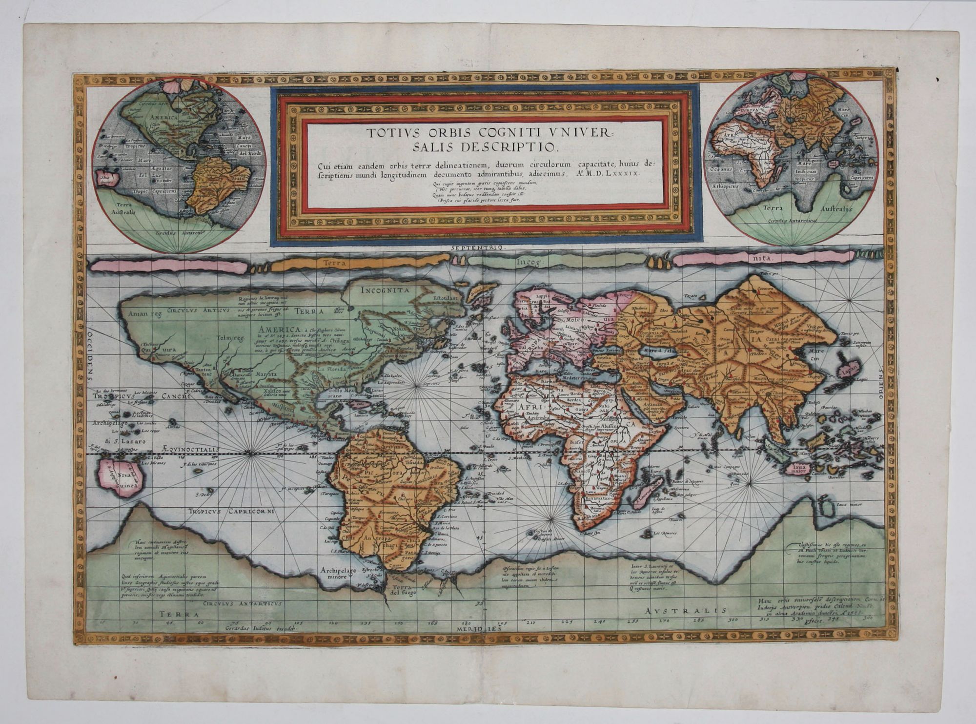
13 ¾ x 20 inches, Fine hand color; fine condition. A beautiful example of a world map that appeared only in the second and final edition of Gerard and Cornelis De Jode’s Speculum Orbis Terrarum. It was engraved by the younger De Jode, Cornelis, in 1589 yet was not published in atlas form until 1593 after the elder De Jode’s death. The 1593 edition of the Speculum introduced maps to replace those in the earlier edition that had been derived from other cartographers. These new maps attempted to keep the Speculum up-to-date with the rapid changes taking place in the European view of the world in the late 16th century. Neither of the two editions of the Speculum was successful commercially, making maps from these atlases rare today. Although this map appears to have been plotted on the Mercator Projection, which was introduced in 1569, this is not the case. While a Mercator projection increases latitude near the poles to correct for the Earth’s curvature, lines of latitude remain constant. This projection has been attributed to Marinus of Tyre, a predecessor of Claudius Ptolemy, who developed the idea of meridians and parallels. . The engraving also includes two hemispherical projections in the upper left and righthand corners. The Southern Hemisphere is dominated by a vast Terra Australis Incognita, which includes Tierra del Fuego. South America appears in the “potato” form made familiar by Mercator and Ortelius. North America, delineated much in the same tradition, is heavily speculative: the fictional regions of Anian and Norumbega appear prominently. Legendary cities of wealth such as “Quivira” and “Cevola” (both of which Coronado sought) are also on the map. The De Jodes had the misfortune of attempting to enter the atlas market at the same time as the highly successful Abraham Ortelius, whose Theatrum Orbis Terrarum would be issued in thirty-seven editions. Despite the quality of the De Jode atlas – many of the De Jode maps are thought to be superior to Ortelius’s – commercially, it was no match. The lack of success and hence the scarcity of the De Jode atlas are often attributed to his rival’s superior political and business connections. Ortelius was able to enjoy a license and monopoly for his atlas, whereas De Jode’s efforts to secure a license were fruitless for many years. There are indications that Ortelius actively maneuvered to have De Jode’s application for ecclesiastical and royal imprimatur delayed until his own expired; at any rate, the first copies of the Speculum were not sold until 1579, nine years after Ortelius’ work was first published. After Cornelis De Jode's death in 1600, the plates for the Speculum were purchased by Jan Baptist Vrients, who was then publishing Ortelius’ atlas, in order perhaps to remove them from circulation, since there were no later printings of De Jode’s maps. Shirley 165.
* Shirley 165.
Sold