![Item #350011 Map Of The State Of New York...1851. [Separately:] Drawn And Engraved By Sherman & Smith New York. SHERMAN, SMITH/ ENSIGN, THAYER, publishers.](https://martayanlan.cdn.bibliopolis.com/pictures/350011.jpg?width=768&height=1000&fit=bounds&auto=webp&v=1521819738)
![Map Of The State Of New York...1851. [Separately:] Drawn And Engraved By Sherman & Smith New York.](https://martayanlan.cdn.bibliopolis.com/pictures/350011_2.jpg?auto=webp&v=1521819738)
![Map Of The State Of New York...1851. [Separately:] Drawn And Engraved By Sherman & Smith New York.](https://martayanlan.cdn.bibliopolis.com/pictures/350011_3.jpg?auto=webp&v=1521819738)
![Map Of The State Of New York...1851. [Separately:] Drawn And Engraved By Sherman & Smith New York.](https://martayanlan.cdn.bibliopolis.com/pictures/350011_4.jpg?auto=webp&v=1521819738)
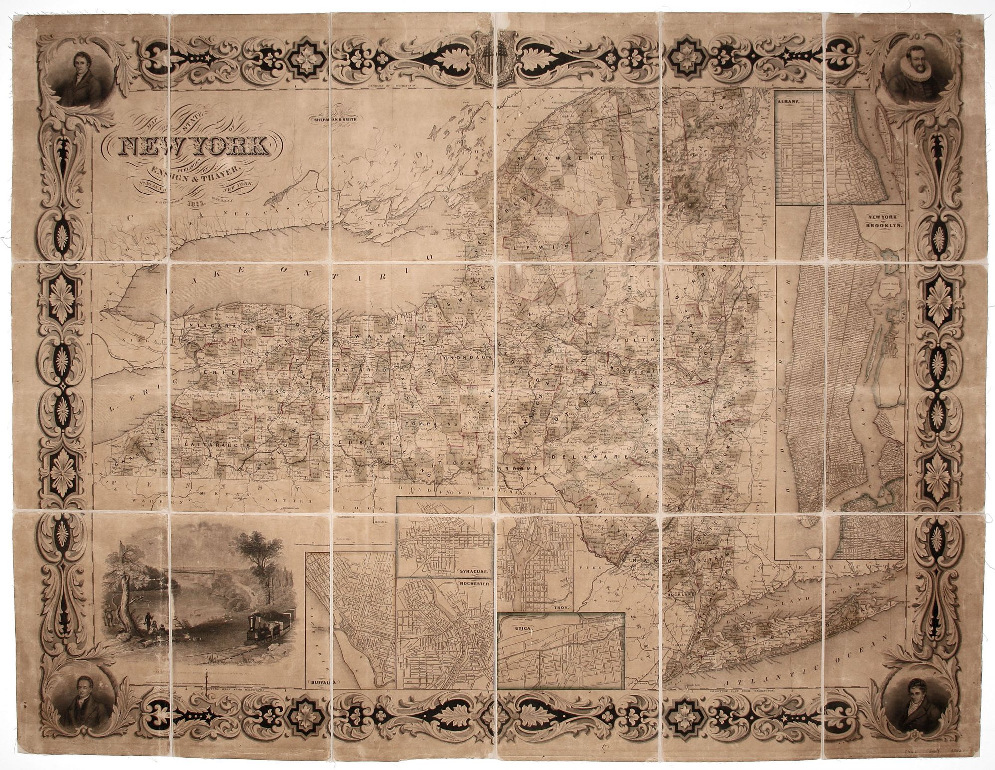
Map Of The State Of New York...1851. [Separately:] Drawn And Engraved By Sherman & Smith New York.
32 x 41 inches, Steel engraving with original color, somewhat faded; dissected & mounted on linen as issued; toned, minor abrasion & losses at fold intersections, else very good.
An evidently rare, elegantly engraved small wall map of New York State with well-executed portraits of De Witt Clinton, Robert Fulton, Daniel D. Tomkins, and Henry Hudson in the corners. OCLC lists just a single copy of this edition, at NYSL, and single copies of 1853 and 1858 editions, also at NYSL, and an 1850 edition at NYPL. We have not found market records for any edition.
The map is valuable in documenting the rail lines in the state at this relatively early point in their development. A rail line can be seen shadowing the Erie Canal, spelling the demise of that great work of infrastructure. A rail line also traverses all of Long Island. Echoing the importance of railroads at the time, the illustration at lower left depicts a train steaming through the region near Niagara Falls.
The work has seven city street plans including a large one of New York City and part of Brooklyn; it is large enough to allow the inclusion of street names on the plan itself. The other plans are of Buffalo, Albany, Syracuse, Rochester, Utica and Troy.
Sold