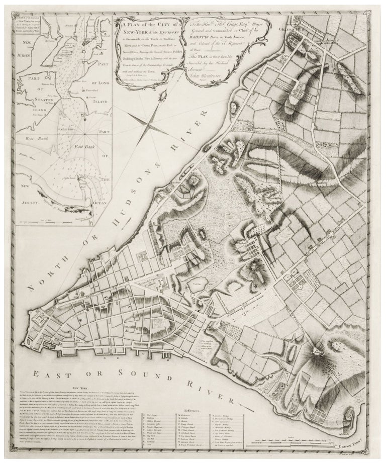
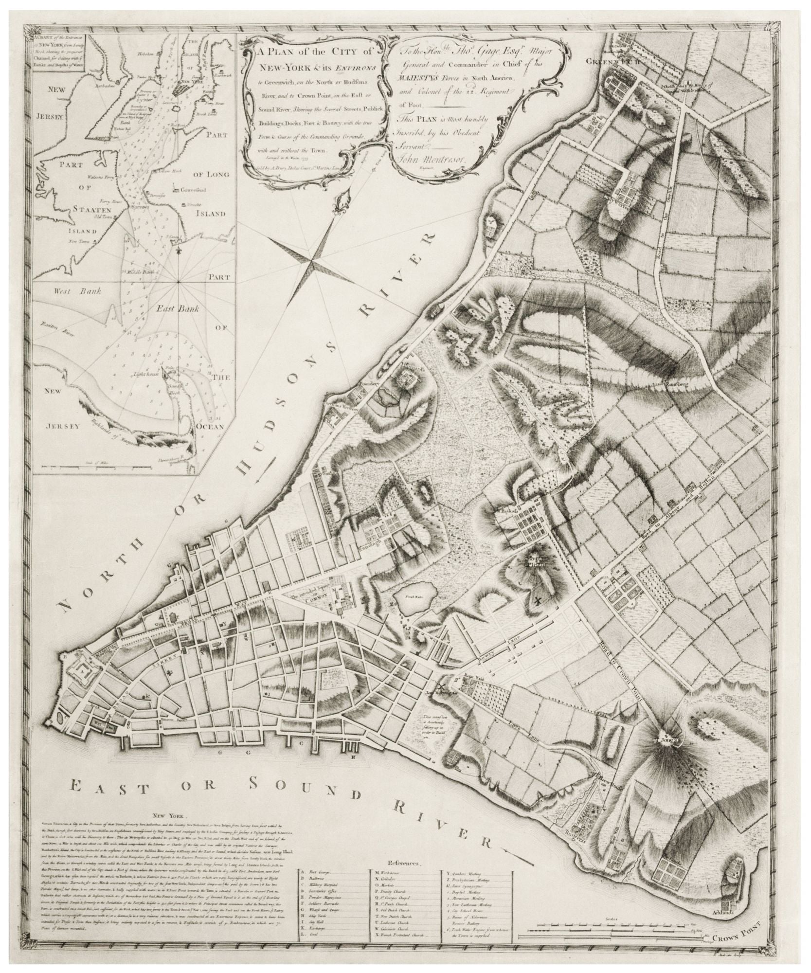
A Plan of the City of New-York & its Environs to Greenwich... Survey'd in the Winter, 1775 Sold by A. Dury, Dukes Court St. Martins Lane.
25 ¼ x 20 ½ inches. Lightly toned, few tears skillfully repaired, still in all excellent condition. Rare. A superb, separately published, never bound example of one of the most beautiful and historically important, early plans of New York City. The city is seen here as it was in the years leading up to the American Revolution, when its developed streets reached only as far as just north as today’s Canal Street. The skillful engraving provides both a street plan of the city itself as well as an evocation of the early landscape of the area north of city prior to its development. This area is here revealed as a patchwork of cultivated fields separated by rolling hills and country lanes that are interspersed with large estates with fine ornamental gardens. These were the country homes of the city’s commercial elite, and their owners are named on the plan. Also depicted are a ten-acre lake called The Fresh Water or Collect Pond as well as numerous streams, rivers, marshes and forest. Greenwich Village can be seen as an actual village in the northernmost part of the plan. Within the street plan is King's, later Columbia College, shown here for the first time on a map. The plan was drafted in 1765 and 1766 by the British military engineer, Captain John Montresor, by order of General Thomas Gage, then Commandant of the British forces in North America headquartered in New York City. At the time, violent riots were sweeping the city, as colonists protested the Stamp Act and other onerous measures of the Crown. Since an adequate plan of the city did not exist at the time, Gage ordered Montresor to prepare one to aid in planning strategy in the event of a full-scale insurrection. Montresor was required to carry out his surveys in clandestine fashion for fear of discovery by local citizenry. The evidence of his haste can be seen in the fact that the street plan is clearly incomplete with only a few streets named, and their sizes often distorted. However, at the bottom is an important list of 33 structures—including defenses--that is keyed to the plan. There is also a detailed nautical chart of the harbor in the upper left. In the lower left is an account of the city containing a detailed and highly critical description of the town's fort, as scrutinized by a professional engineer's eye. It is interesting that the French, soon-to-be allies of the Americans, were able to lay hands on this plan of such a sensitive area with apparent ease. New York, after all, remained the headquarters of British forces in America throughout the entire Revolutionary War. As Mary Pedley pointed out in her excellent study (see below) of the English and French map industry of this period, “it was common practice in eighteenth-century London for military engineers to have their maps engraved and printed privately.” At the time, no government or military agencies had facilities for the printing of maps, and there were no secrecy constraints at the time that prevented military mapmakers from engaging with commercial publishers. There were various motivations for this: career advancement and monetary reward, honoring one’s regiment or patron, and setting the historical record straight. Pedley goes on to describe the lively and open trade that existed between English and French map sellers, which was carried on without interruption almost until the end of the war. Montresor brought this survey of New York and other maps to the London publisher, Mary Ann Rocque, widow of the mapmaker and publisher, John Rocque. The original manuscript of the plan still hangs at Firle Place, the ancestral home of the Gage family. An edition was published in 1766, but it was evidently not successful, as only a few examples of this edition have survived. It was then re-published from the same plate in 1775 by A. Dury. It is deceptively stated on this edition that the plan was "Survey'd in the Winter, 1775," a totally false claim to make the plan appear more current, thus more commercially appealing. Only these two states of the English edition of the map are known; a French re-engraving appeared in 1777.
* Augustyn/Cohen, Manhattan in Maps, pp. 70-2; Nebenzahl, K. Atlas of the American Revolution, Map 11, p. 85; Tooley, R.V. Mapping of America, p. 213, #126, pl. 126; Haskell, D.C. Manhattan Maps, no. 307.d.
Sold