![Item #250000 A Map of the British and French Dominions in North America with the Roads, Distances, Limits, and Extent of the Settlements, Humbly Inscribed to the Right Honourable The Earl of Halifax … [Imprint:] Publish'd by the Author Febry 13th 1755 according to Act of Parliament, and Sold by And: Millar opposite Katharine Street in the Strand. John MITCHELL.](https://martayanlan.cdn.bibliopolis.com/pictures/250000.jpg?width=768&height=1000&fit=bounds&auto=webp&v=1548705452)
![A Map of the British and French Dominions in North America with the Roads, Distances, Limits, and Extent of the Settlements, Humbly Inscribed to the Right Honourable The Earl of Halifax … [Imprint:] Publish'd by the Author Febry 13th 1755 according to Act of Parliament, and Sold by And: Millar opposite Katharine Street in the Strand.](https://martayanlan.cdn.bibliopolis.com/pictures/250000_2.jpg?auto=webp&v=1548705452)
![A Map of the British and French Dominions in North America with the Roads, Distances, Limits, and Extent of the Settlements, Humbly Inscribed to the Right Honourable The Earl of Halifax … [Imprint:] Publish'd by the Author Febry 13th 1755 according to Act of Parliament, and Sold by And: Millar opposite Katharine Street in the Strand.](https://martayanlan.cdn.bibliopolis.com/pictures/250000_3.jpg?auto=webp&v=1548705452)
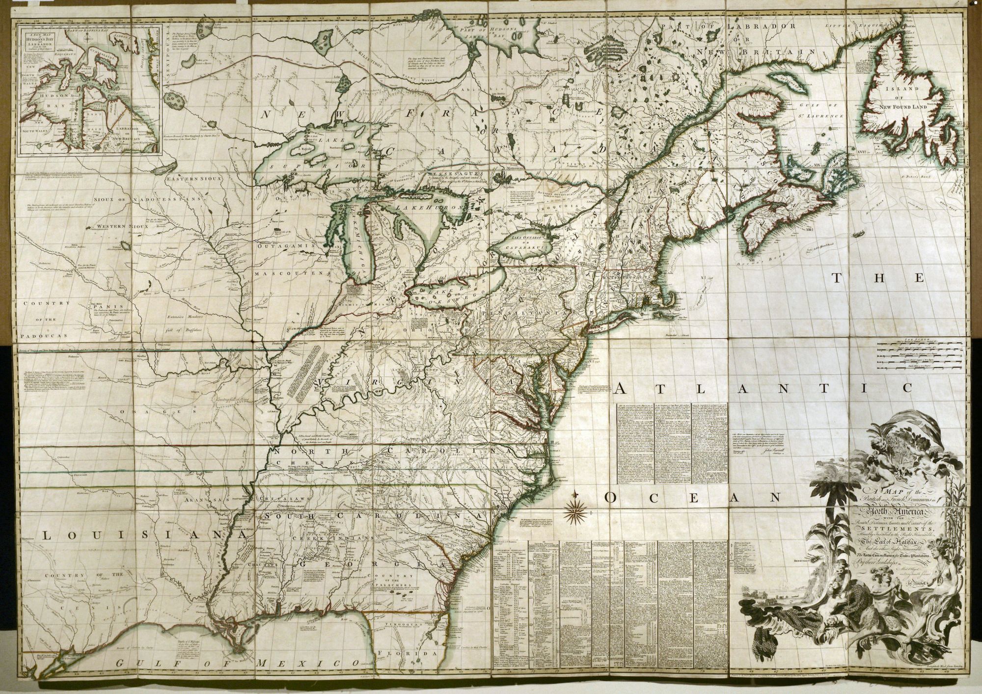
A Map of the British and French Dominions in North America with the Roads, Distances, Limits, and Extent of the Settlements, Humbly Inscribed to the Right Honourable The Earl of Halifax … [Imprint:] Publish'd by the Author Febry 13th 1755 according to Act of Parliament, and Sold by And: Millar opposite Katharine Street in the Strand.
Segmented into sheets, each measuring 13 x 9 ½ inches and mounted on original linen, all as issued; total size if joined: 52 x 75 inches approximately. Housed in original, marble paper over boards, slip case with one side containing an ms. identification of the map and the other, a printed advertisement for the Jefferys firm; the bookplate of the Earl of Dalhousie affixed to map. Vibrant original outline & wash color; some very light staining but overall superb condition. A remarkable example of the work that was the map-of-record at the birth of the United States and which continued in this role through several decades in the early life of the country. Not only is the map itself exceptionally well-preserved, but also, in a remarkable survival, the original slip case is present. Mitchell's map was the cartographic document consulted by official representatives of Great Britain and the United States at Paris in 1782 and 1783 in negotiating the treaty that terminated the Revolutionary War, recognized the independence of the United States, and delineated the borders of the new country. Since all examples of the Mitchell map were separately published, and the majority of these appear to have been issued as wall maps, it has always been a rare map on the market. However, an example as well-preserved as this one is of the utmost rarity. Our copy corresponds to State 4 as described in Pritchard/ Taliaferro, which was the final state published by Mitchell himself. This state was also the first to add important text in the Atlantic Ocean area describing the making of the map and the emendations made to this state. Further, our copy corresponds to what Ristow describes as the second edition in A La Carte (p. 109). In fact, the copy described by Ristow, and ours, appear quite similar with the exception of the wording on the handwritten label on the slipcase and the presence of ms. annotations on the LC copy. It would not be until 1773 that a new edition appeared, which was issued by Jefferys & Faden. Thus, this State 4 would have the most up-to-date issue available during the crucial period that saw the conclusion of the war for North America between England and France. Interestingly, the slip case of our copy has affixed to one side a printed label that begins: “Bought of Thomas Jefferys Engraver,…” The text goes on in the form of an advertisement to describe the great variety of prints along with maps that Jefferys offered for sale. This label reveals Jefferys’ early involvement with the Mitchell map as a distributor before becoming a publisher of it. Our copy of the map also has a potentially very interesting association. The map has affixed to it the bookplate of the Scottish nobleman, Earl of Dalhousie. Assuming the plate is roughly contemporaneous with the publication of the map, which it appears to be, this would have made the original owner Charles Ramsay, the 7th Earl of Dalhousie, who died in 1764, or his brother, George, who succeeded him as the 8th Earl and who died in 1787. What is potentially most interesting is that George, the 9th Earl (1770-1838), was the Governor of Canada and possibly the map was used in this capacity. To get even a partial sense of the historic uses to which the map was put, we quote Martin (as quoted by Ristow, pp. 104-05). “It is thought to have been in use in the British House of Commons during the debate on the Quebec Act of 1774; it is known to have hung in the halls of Congress in 1802 and several times subsequently. It was used ... in the discussions of British land grants in the Ohio and Mississippi valleys, and in scores of controversies involving the boundary lines existing at the time of its publication. Great Britain and the United States agreed to its official status in the Convention of September 29, 1827.... it exerted substantial influence in the negotiation and ratification of the Webster-Ashburton Treaty of 1842, and serious argument was based upon it by Great Britain before the Court of Arbitration at The Hague in 1910 in connection with the North Atlantic Coast Fisheries Arbitration. It was submitted in evidence before the Law Lords of the British Privy Council in 1926 in the appeal of Price Brothers & Company, Limited, from a judgment of the supreme court of Canada, and in 1926-27 in the Canada-Newfoundland (Labrador) boundary case. It was used as evidence before the Supreme Court of the United States in the Wisconsin-Michigan boundary case, in 1926-27 in the Great Lakes level case, and in 1932 in the New Jersey-Delaware boundary case." - Martin Mitchell was concerned about the active French expansion throughout the Old Northwest and the seeming disinterest of the British authorities in enlarging and solidifying their colonial possessions. He commenced work on the map in 1750 and was occupied in compiling it for the next five years. Through his close relationship with George Dunk, Earl of Halifax, he had access to the extensive collection of manuscript maps and geographical reports in the archives of the British Board of Trade. Mitchell's map was issued in 1755 with the approval of, and at the request of the British Government and was dedicated to the Earl of Halifax, who was then President of the Board of Trade. It bears the endorsement of John Pownall, Secretary of the Lords Commissioners for Trade and Plantations, dated February 13, 1755.
* Pritchard/ Taliaferro, Degrees of Latitude, no. 33, State 4; Ristow, W. "John Mitchell's Map of the British and French Dominions in North America," in Ala Carte, pp. 102-110; Schwartz, The Mapping of America, pp. 159-160; Stevens & Tree 54c.
Sold