![Item #205 This Indenture [with] A Map of Mr. George Gosmans Lots and Buildings in Greenwich Street formerly Sir Peter Warrens Ground. New York, Feb 8th 1796. Casimir Th. Goerck. City Surveyor. Casimir Th GOERCK, cartographer.](https://martayanlan.cdn.bibliopolis.com/pictures/205.jpg?width=768&height=1000&fit=bounds&auto=webp&v=1549910232)
![This Indenture [with] A Map of Mr. George Gosmans Lots and Buildings in Greenwich Street formerly Sir Peter Warrens Ground. New York, Feb 8th 1796. Casimir Th. Goerck. City Surveyor](https://martayanlan.cdn.bibliopolis.com/pictures/205_2.jpg?auto=webp&v=1549910232)
![This Indenture [with] A Map of Mr. George Gosmans Lots and Buildings in Greenwich Street formerly Sir Peter Warrens Ground. New York, Feb 8th 1796. Casimir Th. Goerck. City Surveyor](https://martayanlan.cdn.bibliopolis.com/pictures/205_3.jpg?auto=webp&v=1549910232)
![This Indenture [with] A Map of Mr. George Gosmans Lots and Buildings in Greenwich Street formerly Sir Peter Warrens Ground. New York, Feb 8th 1796. Casimir Th. Goerck. City Surveyor](https://martayanlan.cdn.bibliopolis.com/pictures/205_4.jpg?auto=webp&v=1549910232)
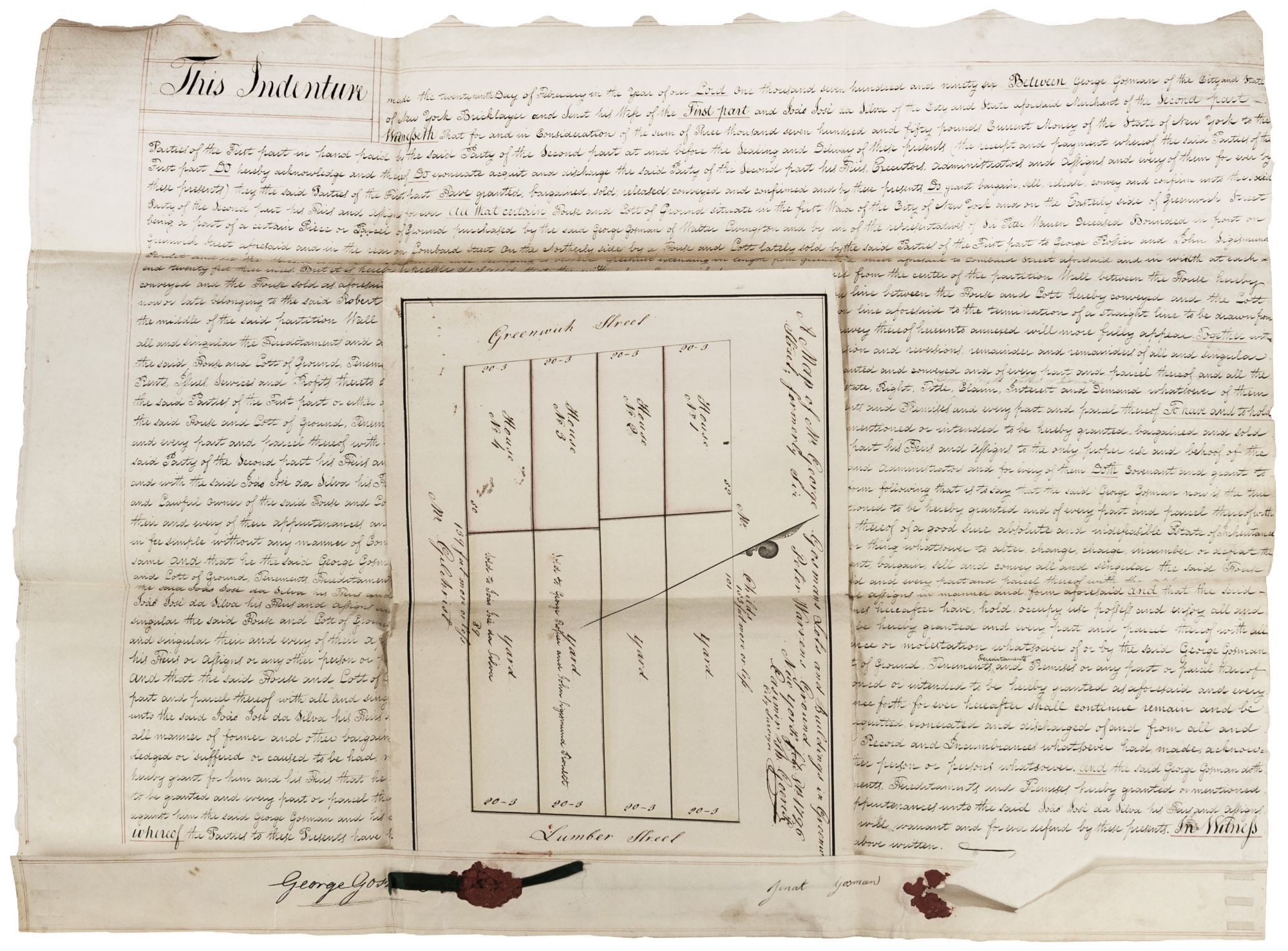
This Indenture [with] A Map of Mr. George Gosmans Lots and Buildings in Greenwich Street formerly Sir Peter Warrens Ground. New York, Feb 8th 1796. Casimir Th. Goerck. City Surveyor.
Map 10 ½ x 15 inches, indenture overall, 22 x 28 ½ inches, Indenture in pen & ink on vellum with red wax seals; map on heavy paper in pen & ink with light watercolor wash; gap along edge of indenture where part of a seal had been, else excellent. An 18th-century real estate contract (indenture) for the sale of two properties in lower Manhattan, accompanied by a fine manuscript survey by Casimir Goerck, the City Surveyor at the time and a key figure in the eventual creation of a plan for the streets of Manhattan. The properties were between Greenwich Street and Trinity Place in the area of Trinity Church on the lower west side. A witness and signer of the document was Peter Augustus Jay, a prominent lawyer, city official, and the son John Jay. Casimir Goerck made surveys in 1785 and 1796 that played a substantial role in the development of the future gridded street scheme for Manhattan. In 1797, Goerck collaborated with Joseph François Mangin to produce New York City’s first real estate map, the huge Mangin-Goerck Plan. Mangin was a French-born architect and apparently the front man for negotiating the contract for the map with the City Council. Goerck’s death at the end of 1798 left Mangin to complete the map alone. The map they had proposed — a detailed depiction of the locations of houses, lots, buildings, streets and wharfs — was not what Mangin eventually produced in 1803; it was, in fact, an idealized conception of what the city's street layout should look like. It was thus summarily rejected and castigated by the City Council as completely failing in its mandate. As a result, this monumental plan is of extreme rarity. Nevertheless, a close examination of the 1811 Commissioners' Plan, the adopted planning document for the city's streets, reveals that a significant part of the Goerck-Mangin plan was incorporated into it. The delicately drawn survey accompanying the indenture shows four houses and lots (numbered 1 to 4) owned by George and Jenat Gosman; they were bounded on two sides by Lumber Street (now Trinity Place) and Greenwich Street, and on the other two sides by properties owned by a Mr. Childs and a Mr. Gilchrist. (At the time Lumber and Lombard streets were often confused for each other, and indeed the indenture uses the latter name, while the map correctly uses the former one.) According to the indenture document, House No. 4 was sold to João José da Silva, identified as a merchant, for 3,750 “pounds current money of the State of New York.” The indenture is signed by George Gosman, identified as a bricklayer, and his wife, Jenat, as well as by James Kent and Peter Augustus Jay, as witnesses to the transaction. The indenture mentions, and the map shows, House No. 3 as having been sold by Gosman to George Rossier and John Sigismund Roulette, but transaction covered by the indenture. The title of the map refers to the property as formerly “Sir Peter Warrens Ground,” after the British admiral, who owned considerable property in Manhattan and elsewhere in the northeast. The indenture further states that Gosman purchased the property from Walter Livingston, who had purchased it from Warren's estate. Cf. Augustyn/ Cohen, Manhattan in Maps, pp.96-97. http://www.oldstreets.com/
Sold