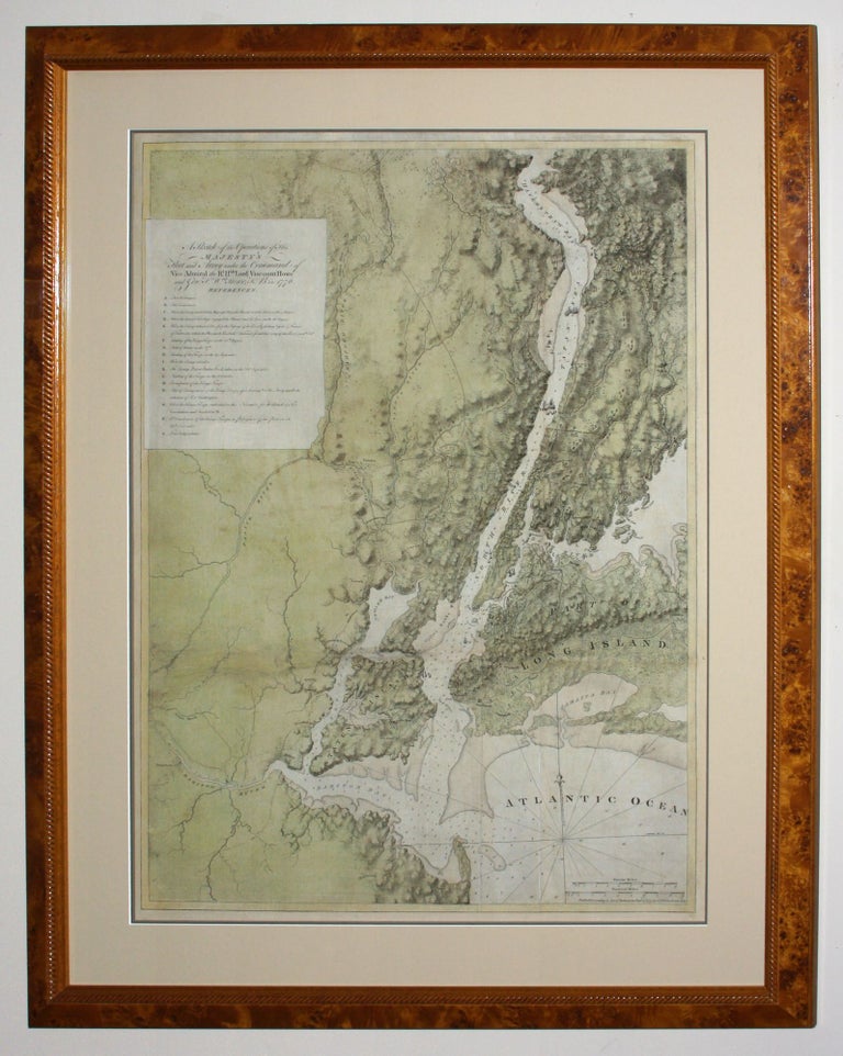
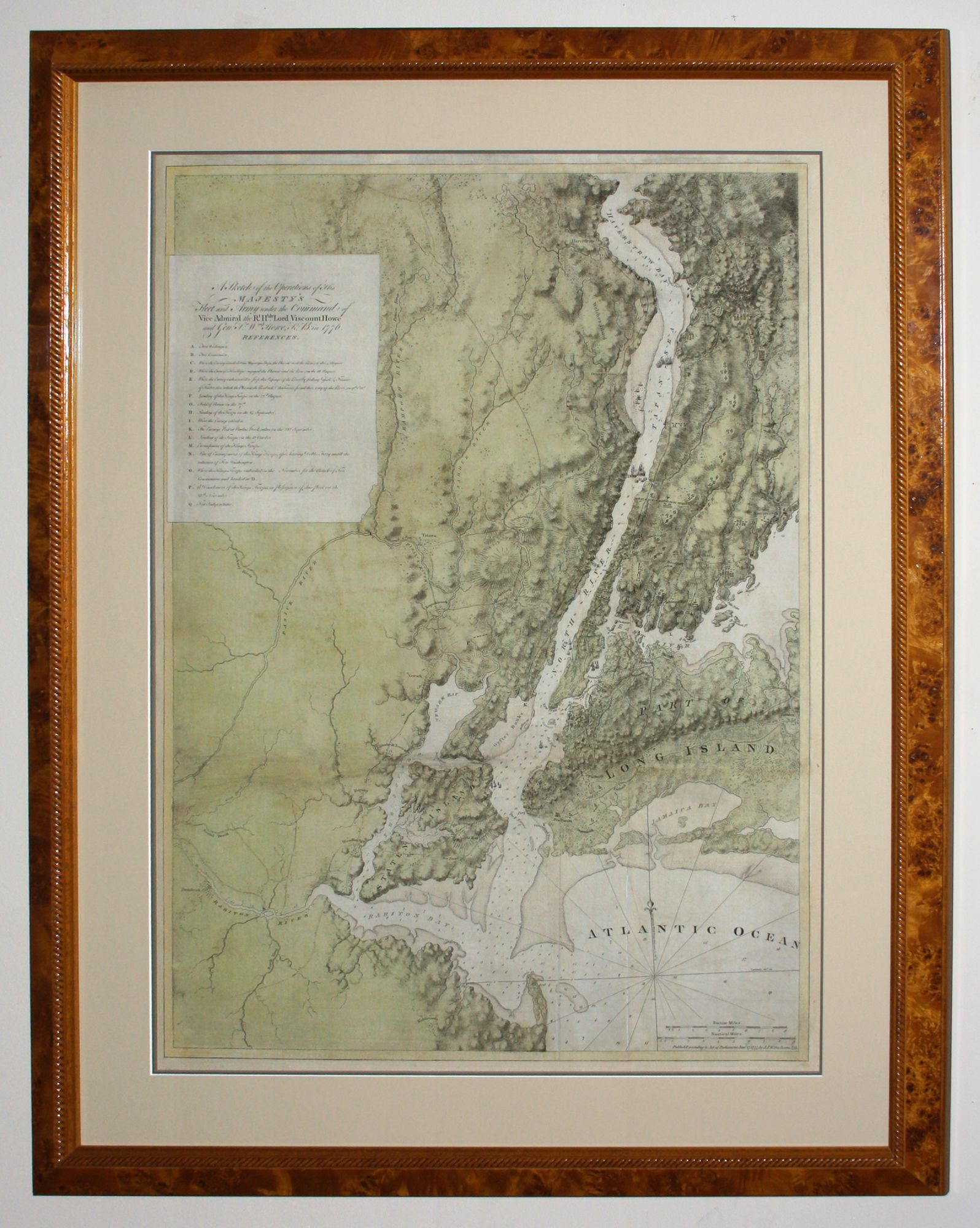
A Sketch of the Operations of His Majesty’s Fleet and Army under the Command of Vice Admiral the Rt. Hble. Lord Viscount Howe and Genl. Sr. Wm. Howe K. B. in 1776.
Full wash coloring; expertly mounted on linen, minor evidence of fold wear & soiling, side margins extended with border area only on left reinstated in ms.; else very good condition. Museum-quality, burled wood framing. "One of the greatest of the Atlantic Neptune charts, with the best topographical information on the lower Hudson River valley, western Long Island, and Staten Island” (Nebenzahl, Bibliography). A rare and highly evocative map that provides a cartographic overview of both the ground and naval actions of the Revolutionary War in the New York region from August of 1776 to November of that year, when British forces completed their conquest of Manhattan. This is also one of Des Barres’ most accomplished as well as unusual works in being equally a topographic map and hydrographic chart. The work’s subtle shading vividly evokes the rugged topography along the Hudson River. The map also provides detailed soundings for the Hudson River and New York Bay and Harbor. Shown also are roads, areas of habitation, and alphabetical symbols keyed to legends identifying the major events of the campaign. These include the site of the British landing at Gravesend Bay in Brooklyn on August 22nd; the August 27th Battle of Brooklyn (or Long Island or Woody Heights); the launching of American fire ships against the HMS Phoenix and Rose on October 16th; the September 15th British landing on Manhattan Island; the October 28th Battle of White Plains; and the November 16th capture of Fort Washington in northern Manhattan that completed the campaign for the taking of New York. The map was compiled by Joseph F. W. Des Barres and was issued both separately and bound in volumes of The Atlantic Neptune. The Neptune was funded by the British government, itself an unusual circumstance in the production of maps in England to that date, for the use of the British Navy in America during the Revolution. Judging by the result, clearly no expense was spared in its creation; it has been described as “the most splendid collection of charts, plans, and views ever published.” (Rich, Bibliotheca Americana Nova, as cited by Sabin).
Des Barres does not identify his sources for this map, but they were probably several. The topography was likely based on surveys conducted in the 1760s and 1770s by John Montresor, Bernard Ratzer, and/or Claude Sauthier, all of whom published important maps of the area. These may have been augmented by slightly later surveys conducted by Sauthier and/or Charles Blaskowitz, both of whom were present during the British attack and occupation of 1776. The soundings were probably from hydrographic surveys by Samuel Holland taken during his brief stay in the area in 1775 and/or by Blaskowitz in 1776. Finally, the data on troop positions and movements on information was probably obtained from Blaskowitz and/or Sauthier, the latter of whom was with Lord Percy during the battles in and around the city.
Haskell, Manhattan Maps, #486-487. Nebenzahl, Bibliography of Printed Battle Plans, #99. National Maritime Museum (UK) on-line catalogue of charts from the Atlantic Neptune, #HNS 149. Streeter, #706 (vol. III chart 15 in the Streeter copy of the Neptune.) Sellers and van Ee, Maps and Charts of North America and the West Indies, #1057.
For background on Des Barres, Holland and the Atlantic Neptune, see Stephen Hornsby’s superb Surveyors of Empire: Samuel Holland, J.F.W. Des Barres, and the Making of the Atlantic Neptune. Also of value are Cumming, British Maps of Colonial America, pp.51-56; Harley et al., Mapping the American Revolutionary War, pp.25-8; and Machemer, “Headquartered at Piscataqua: Samuel Holland’s Coastal and Inland Surveys, 1770-1774,” Historical New Hampshire vol. 57 nos. 1 &2, pp.4-25.
Sold