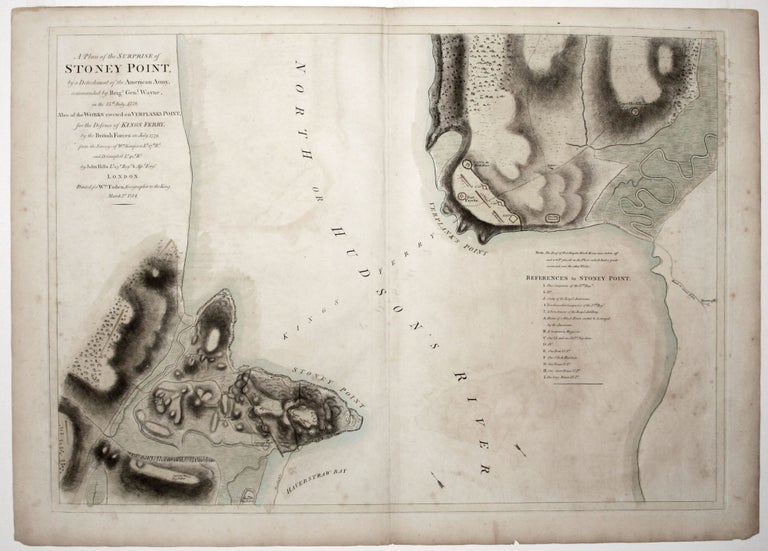
A Plan of the Surprise of Stoney Point, by a Detachment of the American Army commanded by Brigr. Genl. Wayne, on the 15th July 1779. Also the Works erected on Verplanks Point, for the Defence of Kings Ferry, by the British forces in July 1779.
19 3/4 x 27 1/4 inches, Full original wash color; some light offsetting & foxing, else excellent.
Rare, very finely engraved of a little known yet meaningful engagement fought during the War's middle years. In fact, "this splendid engraving is the only battle plan of this engagement published. The detailed rendering of the relief provides one with a dramatic picture of the setting of Wayne's stunning victory" (Nebenzahl). The action transpired in the area of King’s Ferry, one of the most important crossings on the Hudson River, that ran from Verplank’s Point, below Peekskill, to Stoney Point on the west side of the river; the latter is now called Jones Point and is a part of Bear Mountain State Park. Both landings were heavily fortified by the British in the summer of 1779. The performance of American forces under General "Mad" Anthony Wayne on the evening of July 15th, in which they executed a silent, very British-like bayonet charge, was a clear step in the effectiveness of the American Army. And while the area involved was of little strategic value, the American raid netted an estimated 470 prisoners, forces that the British could ill afford to lose in an area so close to New York. As Nebenzahl observed, “Wayne’s dramatic strike at Stoney Point raised patriot morale and gained new respect for the increasingly competent American army." The route of Wayne’s three-pronged attack is shown in dotted lines colored yellow. The area's hilly topography is particularly well rendered. Although the map wasn't issued until just after the war, the engagement it delineates must have been deemed sufficiently important to warrant such a fine, large-scale production.
Lt. John Hills (fl. 1777-1817), the maker of this map, "was unique among his colleagues in that he remained in America after the war, where he worked as a surveyor, land assessor, engineer and mapmaker" (Augustyn/ Cohen). While he produced many maps relating to the Revolution, most are known in only manuscript form, this being one only a few printed examples.
* Nebenzahl, Atlas of the American Revolution, map 32; Nebenzahl, Bibliography of Printed Battle Plans, 145; cf. Augustyn/ Cohen, Manhattan in Maps, pp. 88-89.
Sold