La Figure du Monde Universel.
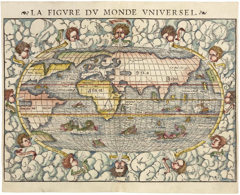
10 ¾ x 14 ¾ inches. Fine hand color; Excellent condition. An excellent example of this early, woodcut world map, rich in the imagery of the Discovery Period with its many sea monsters and surrounding wind heads. The map provides an overview of the known world of the mid-16th century, just after the first great wave of New World discoveries. The North American portion of the map is based on the explorations of Verrazano and Cartier. The former was the source of a famous cartographic myth—the Verrazanean Sea--depicted in all its glory on this map. It can be seen midway up the Atlantic coast of North America, where the Atlantic and Pacific oceans are shown as separated by only a narrow isthmus. As Verrazano sailed north along the Outer Banks off the North Carolina coast, he assumed that the waters to the west of these barrier islands were the Pacific Ocean. Each of the windheads is named, and their appearance on this map and other world maps of the period is reflective of the age of the galley ship, whose performance was highly dependent on wind direction. Sebastian Munster, the Swiss Humanist, was a Renaissance man in the truest sense of the word: a polymath and Hebraist who published on a variety of subjects with great expertise.
* Shirley, R. Mapping of the World, no. 92.
Price: $4,850.00