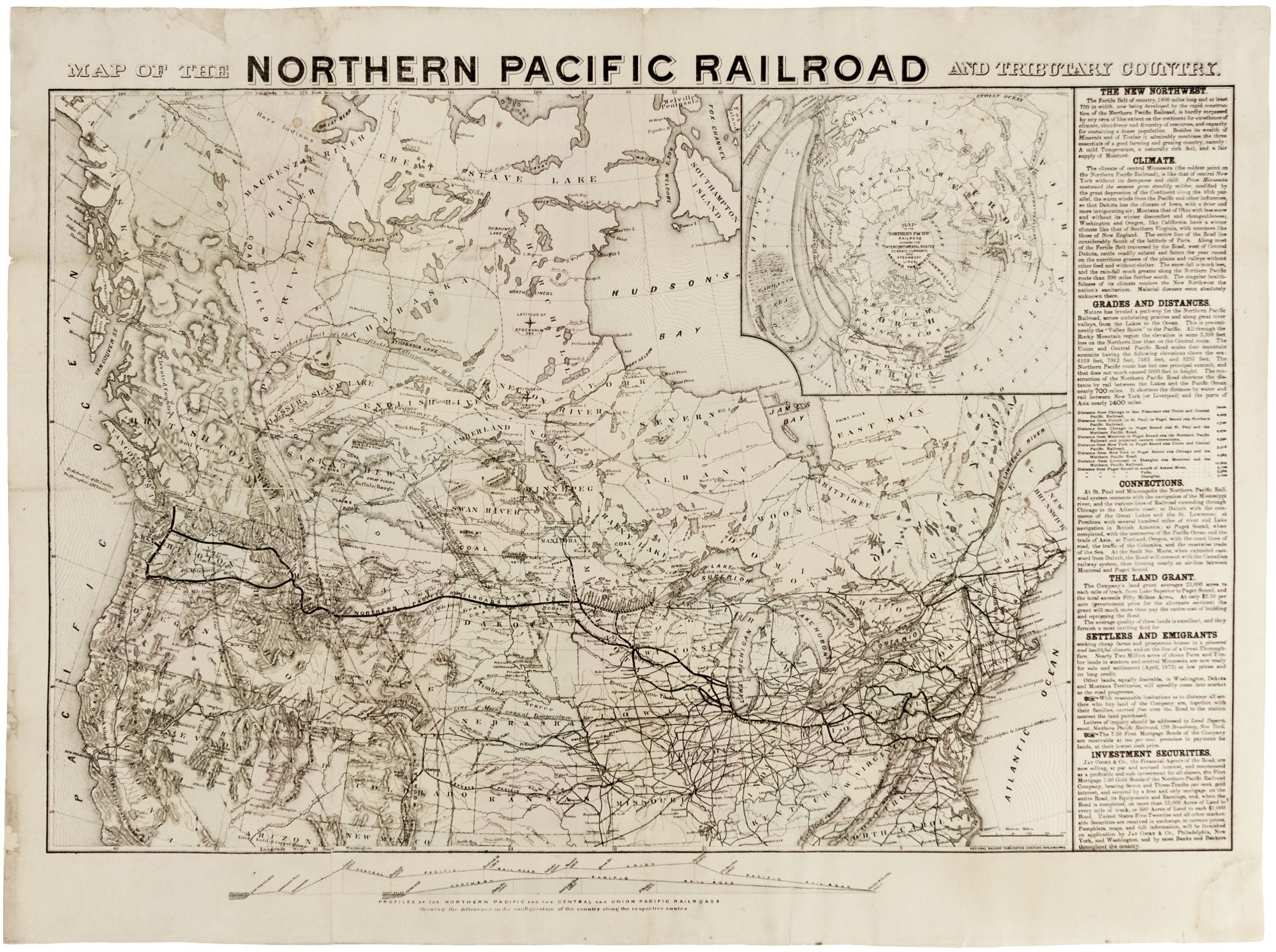
Map Of The Northern Pacific Railroad And Tributary Country.
24 x 33 inches, Lithograph with original hand color; mounted on paper, marginal repairs, else excellent. Railroad companies were the driving force behind much settlement and investment in the American West and Northwest, and maps were a primary tool in this effort. So voluminous were the publications of railroads that it necessitated the formation of the National Railway Publication Company, which produced this map. This rare, separately published map is one of the most ambitious and ingenious promotional maps we've seen. It is also unusual in focusing on the northern tier of the United States and Canada. Railroad companies were granted large tracts of land on either side of the lines they were building to enable them to secure the capital to fund projects of this scale. As noted on this map, "the Company's land grant averages 23,000 acres to each mile of track, from Lake Superior to Puget Sound, and the total exceeds Fifty Million Acres." Thus, to be in the railroad building business was perforce to being in the business of real estate sales. In addition to the expected pitches for the lands for sale based on appealing climate and fertility of the soil, this map employed other devices, some unique to it, to lure investors. It utilizes, for example, the graphics of climatology to delineate the limits of the cultivation of particular crops. Waves of shaded, isothermal lines bend far to the north to lend seeming scientific authority in making a less than credible point. To provide assurance, numerous forts are shown throughout the near and far west, and natural resources are also plentifully indicated. The numerous tributary rail lines lend an impression of interconnectedness in much of the country. A global interconnectedness is suggested by the unusual, polar projection map at upper right. It attempts to show that the Northern Pacific Railroad is a major link in a world that is, somehow, connected otherwise by "intercontinental routes, oceanic currents, and steamboat lines." The validity of this is undercut by the placement of the Sargasso Sea in the northern Pacific rather than the northern Atlantic Ocean. Although the Northern Pacific Railroad was approved by Congress in 1864, construction didn't begin until 1870 when Jay Cooke & Co. became its Financial Agent. Cooke, who is mentioned at lower right on the map, brought his financial acumen and promotional wizardry to get the project moving. The line, however, was not completed until 1883. The length of time of its construction was primarily the result the very challenging terrain of its route, which of course contradicts some of the messages of this map. Nevertheless, the railroad's significance was enormous for the near and far West as well as the Northwest, which gained an efficient and inexpensive means to transport its products and resources to eastern markets. Of interest in Canada are the old territorial and provincial designations--Abittibee, Moose, Rainey Lake, Norway, to name a few. A nice sales touch is a directional cross in north central Canada indicating the latitude of Stockholm. Not in Modelski, Railroad Maps, but the map does appear in Phillips, List of Maps of America (p. 622). OCLC: UC-Berkeley, UT-Arlington and Montana State University only.
Sold