![Item #11083 Plano De La Ciudad Puerto De San Agustin De La Florida…[With untitled inset map of Florida]. Toma LOPEZ Y. VARGAS MACHUCA.](https://martayanlan.cdn.bibliopolis.com/pictures/11083.jpg?width=768&height=1000&fit=bounds&auto=webp&v=1541629691)
![Plano De La Ciudad Puerto De San Agustin De La Florida…[With untitled inset map of Florida]](https://martayanlan.cdn.bibliopolis.com/pictures/11083_2.jpg?auto=webp&v=1541629883)
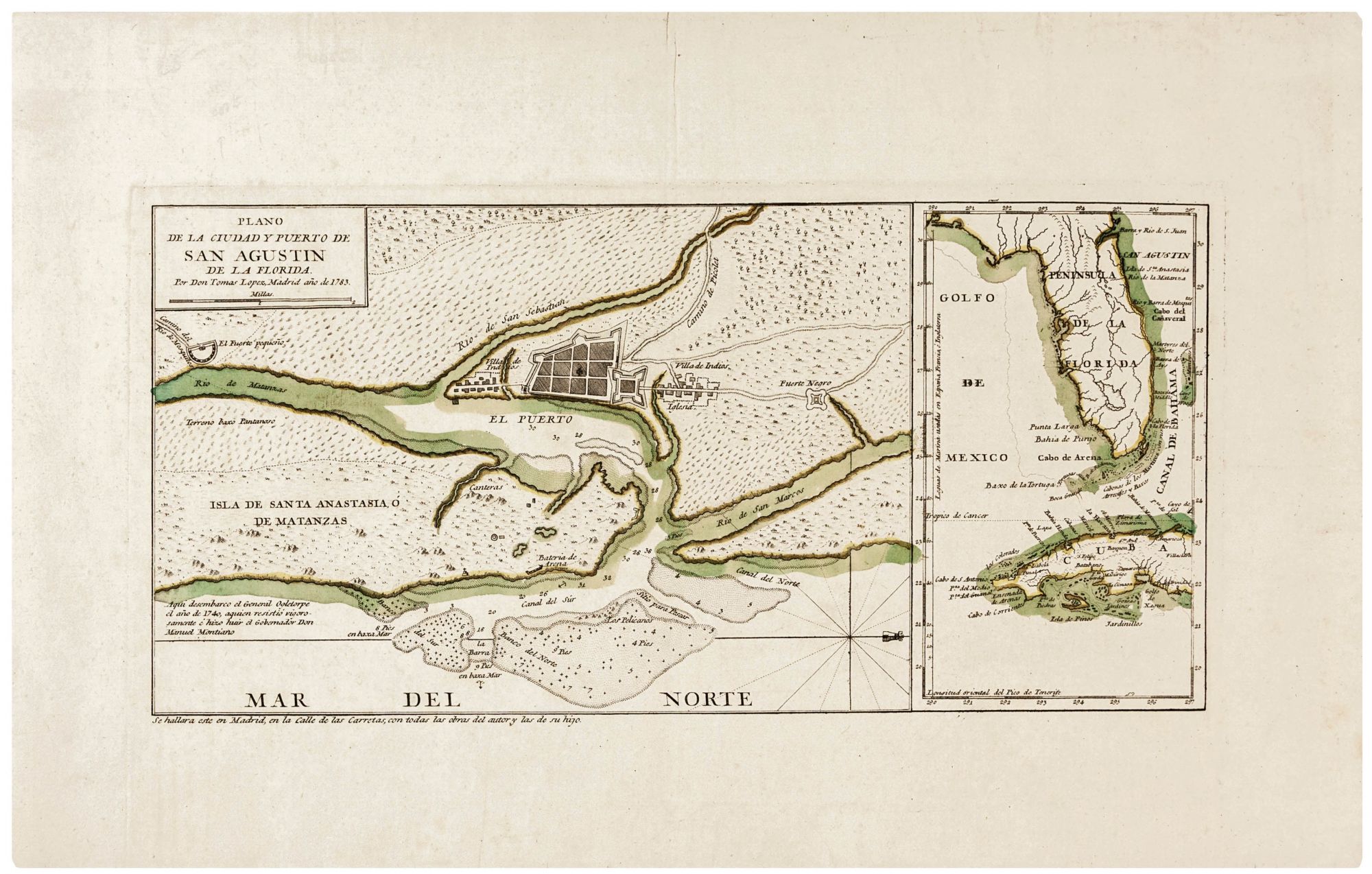
Plano De La Ciudad Puerto De San Agustin De La Florida…[With untitled inset map of Florida].
7 ½ x 15 ¼ inches, Original outline color; excellent condition. Very rare—separately published. One of only a relatively few Spanish-printed maps of Florida appearing prior to 1800; it contains key though relatively little known settlement relating to African-American history. The map was no doubt occasioned by the Spanish acquisition of Florida, both East and West, as a result of the Treaty of Versailles (1783) at the conclusion of the American Revolution. Since St. Augustine was the major settlement in East Florida, it is not surprising it is the focus of this work. The engraving provides a rudimentary plan of the city and includes the surrounding area and waterways along with navigational data for the latter. St. Augustine itself is flanked on either side by Indian settlements. To the north (but to the right on the map) is a small, fortified area called “Fuerte Negro,” which was Fort Mose, the first legally sanctioned African-American community in what is now the United States. Founded in 1738, it was a destination of the original Underground Railroad that led runaway slaves not to the north but south to Spanish-held Florida. Most were escapees from Charleston, South Carolina, the major port for the importation of slaves on the east coast. Upon reaching Florida, escaped slaves were granted freedom if they converted to Catholicism and swore allegiance to the Spanish Crown. See the web links below for more on this fascinating chapter in African American history. An important Spanish map engraver and publisher, Tomas López y Vargas Machuca (1731-1802), was born in Madrid and served as the official Royal Geographer to Carlos III. He studied under D’Anville in Paris before returning to Spain in 1760. López attempted to bring the most modern scientific methodology to his cartographic work. In a career spanning 40 years, he produced more than 200 maps and several atlases. http://www.fortmose.org/; http://www.floridamemory.com/blog/2013/02/18/floridas-underground-railroad-part-two/.
Sold