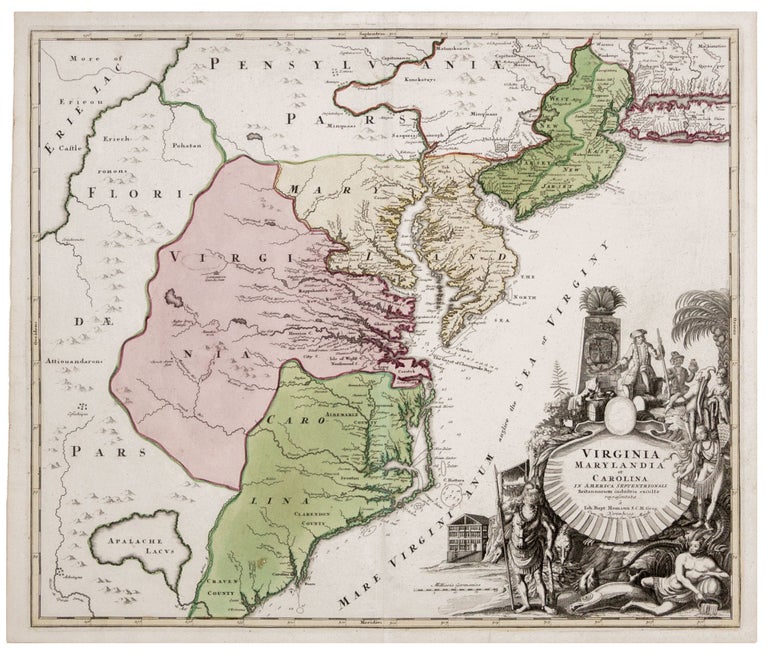
Virginia Marylandia et Carolina In America Septentrionali.
19 ¼ x 22 ¾ inches. Fine original color; small scuff, else excellent condition with a bold strike. A beautiful example of one of the most decorative maps of the area, with a strong impression. Homann’s map has been considered important “because it provides data on settlements of German immigrants. The map was intended to promote German emigration to America." (On The Map). In particular, this map is the first to show the new settlement of Germantown Teutsche Statt, centerpiece of then Governor Spotswood’s plan to settle German immigrants in Virginia. Indeed, the map appears to focus strongly on the work of Governor Spotswood, as another of his projects, Christanna Fort, is on the map as well. Spotswood established Christanna Fort in 1714 as a means to protect tributary Indians from attacks by those who were hostile, such as the Tuscarora, and to facilitate trade between border Indians and the colonists. Christanna would become headquarters of the Virginia Indian Company, a joint stock company established by the Virginia Assembly in 1714 with Spotswood as president to regulate and conduct the trade between the Indians and the Virginians. This wealth of up-to-date detail pertinent to Spotswood is remarkable, appearing as it does on a map otherwise characterized by neither great accuracy nor modernity. Lake Erie has migrated far to the south of its actual location, and its southern shore is claimed by Florida. The mysterious and imaginary lake appearing on maps of Florida as far back as the 16th century is retained on the map as well.
* On The Map, Fig. 27; Cumming 156. Pritchard. M.B. & Taliaferro, H. Degrees of Latitude pp. 106-109
Sold