Map of Port Jackson, and City of Sydney…1867.
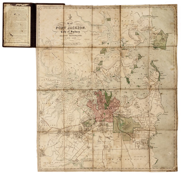
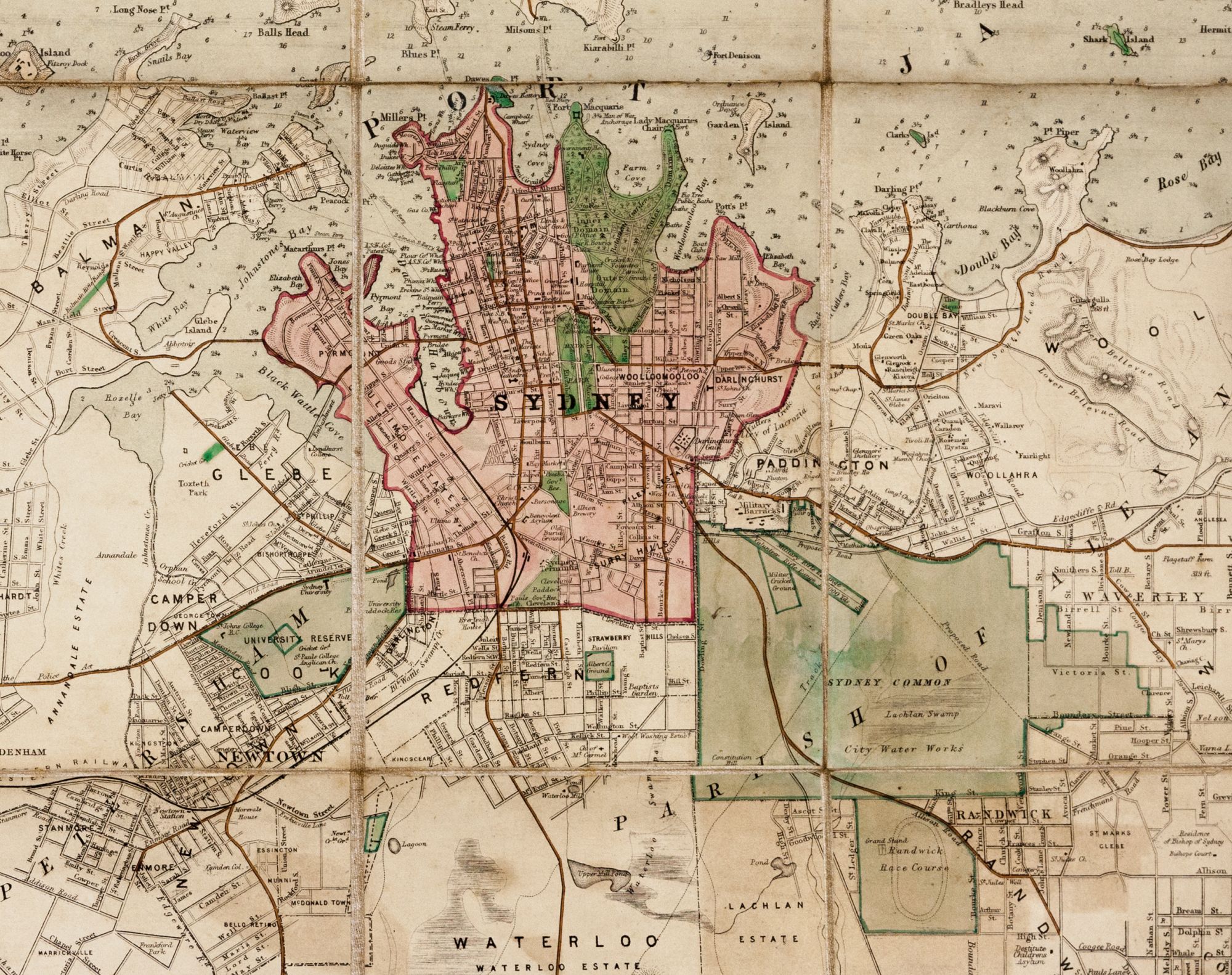
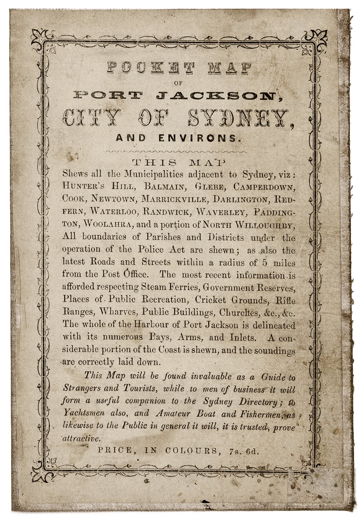
26 x 21 ¾ inches, 66 x 55 cm, Lithograph with original wash color; dissected & mounted on linen as issued, folding into original cover with title in gold on front, testimonials to map on sheet pasted on inside front cover; some staining & age toning to map, overall very good. A highly detailed and accurate map of the city and surroundings, published in Sydney, one of the earliest of the area we've seen on the market is several years. It was drafted by James A. C. Willis, an important crown surveyor as well as a respected topographical artist. Willis compiled the map from his own surveys and those of his colleagues at the New South Wales Surveyor General’s Office. The map embraces the entire vicinity of Sydney in all directions, extending as far north as Curl Curl Head as far south as the northern reaches of Botany Bay, and as far west as Ashfield. The coverage is highly detailed for its scale, demarcating the coastlines with trigonometric accuracy, labelling all major streets and important buildings, as well as naming all neighborhoods and land reserves. The City of Sydney proper is shown to occupy only what is today considered to be its downtown core, here colored in reddish pink. Its suburbs mainly extend to the south, while the semi-urbanized areas (now long since annexed to Sydney) are shown to be isolated villages. The seas and major waterways, notably all of Port Jackson, include copious nautical information, including soundings. Parks, government reserves and forests are colored in bright green. Major buildings labelled in the city proper include the Government House, Customs House, Exchange, St. Andrew’s Cathedral, St. Mary’s Cathedral, Fort Phillip, the Land & Surveyor General’s Office, Prince of Wales Theatre, Royal Hotel, N.S.W. Bank, General Post Office, The Markets and the Australian Museum. The parkland of the Inner and Outer Domains are featured, including the Botanical Gardens. Sydney Common is shown to be largely undeveloped, laying beside the military Barracks, featuring the Military Cricket Ground and Rifle Range. Just a little further to the south is the Randwick Race course. To the southwest of the city proper is the ‘University Reserve’ that shows the University of Sydney (founded 1850) to still be confined to only a single major building. The North Shore is depicted to still be almost entirely rural, save for the urbanization of St. Leonard’s. The Great Southern & Western Railway is shown to run to west and southwest towards Bathurst and Melbourne. As the description / advertisement for the map within the front cover states:“This map will be found invaluable as a Guide to Strangers and Tourists, while to men of business it will form a useful companion to the Sydney Directory; to Yachtsmen also, and Amateur Boat and Fishermen, as likewise t the Public in general it will, it is trusted, prove attractive.” The present example is the second of seven states of the map, the first appearing in 1865. This second state added details such as ferry routes. Five further states were published from the same stone, in 1868, 1875, 1882, 1883, 1885, with the latter four editions bearing the imprint of the firm of S.T. Leigh & Co., with whom Willis maintained close connections. Full color as seen our example is uncommon on the map. James A C. Willis (fl. 1848 – 1896) was an important surveyor in New South Wales during second half of the 19th Century, as well as an accomplished and popular topographical artist. He is thought to have arrived in Sydney around 1845. In 1848, he apprenticed as a draftsman under Conrad Martens, considered to be the colony’s most talented artist. In 1853, Willis became a surveyor and draftsman for the Surveyor General’s Office of New South Wales. In this role, in addition to the present map, Willis created a Map of New South Wales (1871); The Harbour of Port Jackson, New South Wales (c. 1870); County of Bathurst (1869); as well as a fascinating thematic map, the Cereal Map of New South Wales (1871). However, his grandest topographical print was his enormous panoramic view, The Harbour of Port Jackson & City of Sydney drawn from nature by James A.C. Willis (c. 1870). Willis was one of the founders of the NSW Academy of Art and in 1871 was elected as one of its directors. We noted only four institutional examples of the 1867 state, all of which are in Australia (National Library of Australia; State Library of New South Wales; Historic Houses Trust of New South Wales; Royal Australian Historical Society). Only a few examples of the map have appeared on the market in recent decades. The present example of the map has a fine provenance, from the collection of Geoffrey Chapman Ingleton (1908 - 1998). Ingleton served in the Royal Australian Navy from 1922 to 1936 and worked as a draftsman for the Australian Hydrographic Office, from 1940 until 1973. He was also an accomplished writer and maritime artist who wrote and illustrated many books. Over many years, Ingleton assembled one of the largest and finest collections of maps and sea charts of Australia and New Zealand. He sold his collection at auction in 1991 and 1992. The present map bears Ingleton’s catalogue stamp and number (no. 10392) on the linen verso. Also, inside the front cover is the stamp of Berkelouw Bookdealers Sydney. Tooley, Printed Maps of New South Wales, no. 148; National Library of Australia: MAP F 109; OCLC: 219799794.