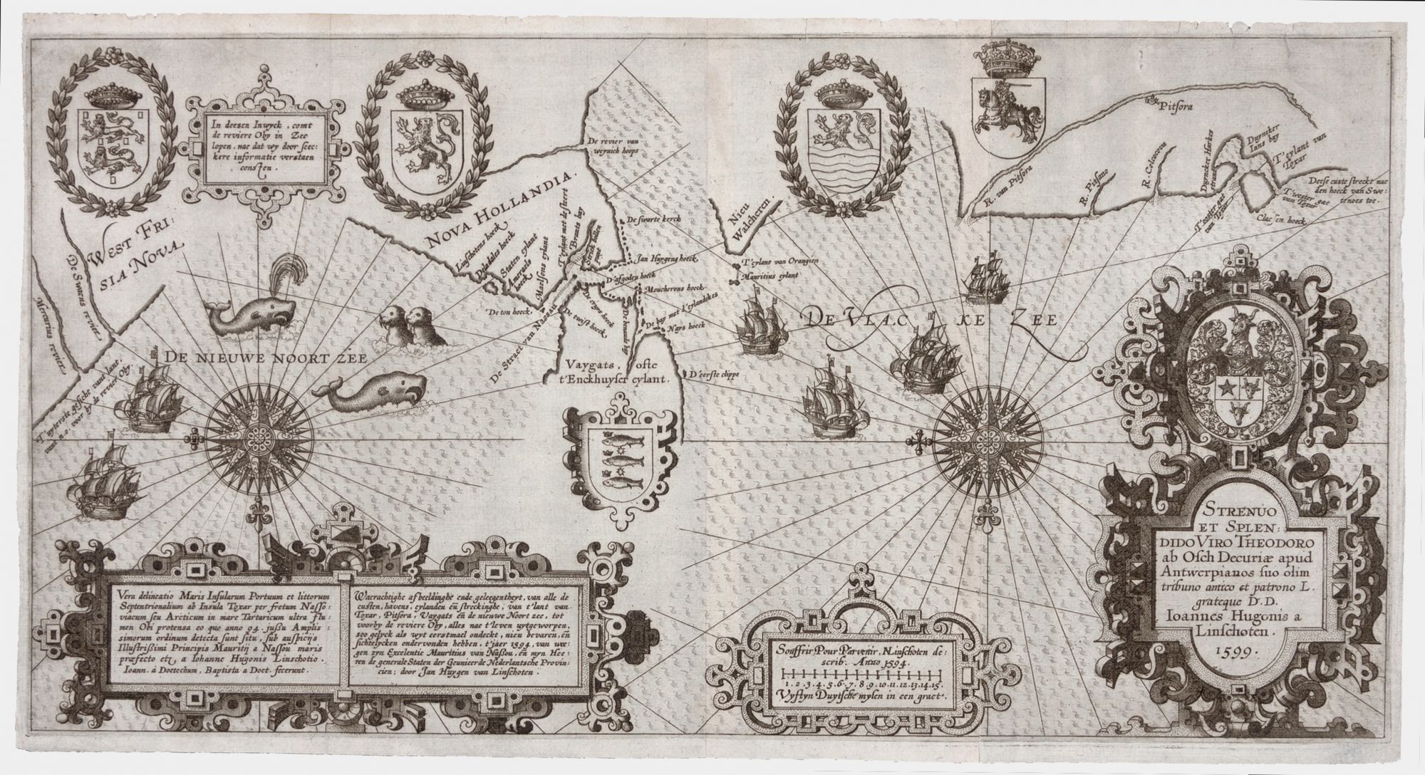
First state of this rare, important and boldly decorative chart that embodies one of the first major successes in the Dutch effort to discover a Northeast Passage. It accurately reveals, for the first time, a key passage along the northern Russian coast. The chart was drawn by Jan Huygen van Linschoten, who took part in the first, 1594 Dutch voyage in search of a Northeast Passage, and appeared in his 1601 “Voyagie, ofte schip-vaert”. Linschoten also participated in the second Dutch voyage in 1595 that sought to use this same route to capitalize on the successes of the first expedition. This southern-oriented chart is decorated with six ships, whales, walruses, and two magnificent compass roses. Six coats-of-arms and elaborate strapwork cartouches complete the decoration of this masterpiece of Dutch nautical engraving.
At the end of the 16th century, the merchant leaders of the Dutch Republic sought to open new trade routes with East Asia that would not run afoul of the Portuguese, who commanded the passage around Africa. Early mapping of the world suggested that an arctic route over Asia might be more direct as well as free of competition. To that end, the Dutch undertook three expeditions between 1594 and 1596. The first two were commanded by Cornelis Nay; Linschoten was the chief commercial officer aboard the ships that were funded by his home town of Enkhuizen (Mercurius in 1594 and Hoop in 1595). The 1594 voyage was deemed a remarkable success. The Mercury and Zeeland’s Zwaan, tasked to find a route eastwards to the south of Nova Zemlya, located and traversed the Yugor Strait between mainland Russia and Vaygach Island. From there, they sailed the Kara Sea. Despite not having reached the mouth of the Ob River, the expedition was satisfied that they had passed it and thus had uncovered a viable route to China.
The chart captures in sharp detail the results of Nay and Linschoten’s 1594 voyage. It is centered on the Yugor Strait, which separates Vaygach Island from the Russian mainland between the Kara Sea and the Barents Sea (De Niewe Noort Zee and De Vlacke Zee on the chart, respectively). Linschoten took advantage of nautical tradition in naming Vaygach Island t‘Enckuyser elant after his hometown and not one but two land features after himself (Jan Huygens hoeck and Linschotens hoeck). The voyage’s patrons are also honored: Orange and Maurits are given islands, and there is a Moucherons hoeck, named after the man to first propose the search for a Northeast Passage. The Yugor Strait itself is named De Straet van Nassau.
The chart’s coats-of-arms, apart from the dedicatory cartouche and that of Russia, give honor to the cities and provinces supporting the voyage. The Enckhuizen arms are shown on Vaygach Island, and those of Zeeland, Holland and Friesland decorate the mainland. It is worth noting that nowhere on the chart is there reference to Amsterdam, which funded Barentsz’s 1594 voyage that occurred simultaneously with Nay’s. While Nay and Linschoten passed through Yugor Strait and pressed eastwards, Barentsz headed north along the coast of Nova Zemlya, ultimately to be blocked by ice floes and forced to return unsuccessfully. Barentsz would accompany Linschoten, again under the command of Nay, for the second expedition of 1595; that voyage would find the Yugor Strait filled with ice and impassable. Barentsz’s well-documented last voyage enshrined him and his crew’s bitter “winter on the ice” in Dutch history but also accorded the navigator and chartmaker a disproportionate share of the credit for the Dutch efforts to probe the Northeast Passage.
