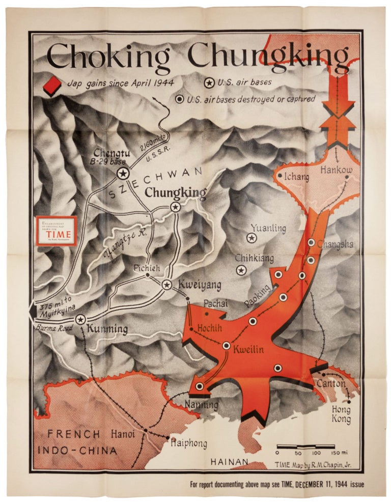
Choking Chungking.
42 x 30 ¾ inches, Offset print in black and red. A few mends at fold intersections, else excellent. In keeping with Henry Luce's and Time Magazine's strenuous support of American war efforts, this poster utilizes bold red strokes to alert its readers to Japanese gains in China in the latter part of the war. Specifically, the map illustrates a major operation called Ichi-go in which the Japanese sent a half million troops along the route of the Pinghan Railroad from Beijing to Wuhan in southeastern China. One purpose of the operation was to establish a direct route to resource-rich Indochina, which the map shows to be imminent. The other was to capture U. S. air bases from which bombers were pummeling the Japanese home islands. Although as the map shows, several U. S. air bases were captured, most bombers were either moved further inland or, primarily, to the Marianas Islands, allowing the bombing of Japan to resume with minimum disruption. "Chungking" (Chongqing) is at the center of the map, and Hong Kong is at bottom right. This is an enlarged version of a map that originally appeared in the December 11, 1944 issue of Time Magazine. It is apparently rare in this large format: OCLC lists four institutional copies, and there are none in map market records. Chapin, who was with Time from 1933 to 1970, is considered a true pioneer in the use of maps in magazine illustration. "American cartographer Robert M. Chapin Jr. revolutionized journalistic cartography with his innovative technique of adding visual information to the maps… 'I try to dramatize the news of the week, [Chapin has said] not just produce a reference map like those in an atlas'…Chapin’s journalistic cartography became world renowned because of the rigorous geographical details of his maps, and it was (and still is) regularly used as reference material by the American National Library, NASA, the Army andthe Navy, as well as by foreign governments, American and international schools and history book publishers." Elson, R. T. TIME: The Illustrated History of the World's Most Influential Magazine (Beaux Arts Editions).
Sold