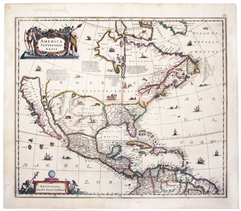
America Septentrionalis.
18 1/4 x 21 1/2 inches. Fine original color; minor mend in lower blank margin at centerfold; excellent.
A beautiful example of one of the earliest, acquirable maps to focus on what is now the United States. The Jansson-Hondius was also one of the first Dutch atlas maps to show California as an island, preceded only by the Hondius world map of 1630. A note on the map recounting the story of the origin of the California-as-an-island myth refers to a Dutch captain who obtained a map of California depicted as an island from a captured Spanish ship. The note even provides the dimensions of the island. The Jansson-Hondius was thus an important conduit for bringing the island myth into the cartographic mainstream. Further, Tooley noted that the map was also "first attempt in Holland to add lakes connected to the St. Lawrence." One of these lakes on the map is in the approximate shape and position of Lake Ontario.
This was also one of a very few, early Dutch maps specifically of North America (as opposed to the entire Western Hemisphere). Aside from the rare De Jode map of 1593, this is the only folio-sized map of North America produced during the entire Dutch Golden Age.
The map’s ornamentation is also of significance, as it provides some of earliest illustrations of animals associated with the American West, such as a Longhorn steer, buffalo, and wild horses.
* Burden 245, state 2; McLaughlin, California as an Island, no. 6; Tooley, America, p. 311; Goss, North America, p. 72; Karpinski, p. 89.
Price: $6,000.00