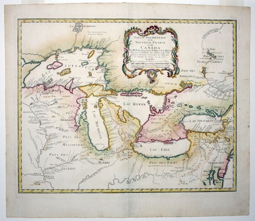
Partie occidentale de la Nouvelle France ou du Canada.
18 ¾ x 24 ¼ inches. Original outline color; fine condition.
The original Bellin issue of this richly detailed map, including some of the most significant updates to the mapping of this region since Del’Isle’s 1718 map. It exercised a strong influence on many Great Lakes maps produced in the mid-18th century. Extensive and descriptive notations mark Indian tribal territories and French trading forts throughout the Great Lakes region, including Fort Ponchartrain near the site of present day Detroit. Several innovations in this map were fictitious; the islands Philippeaux and Pontchartrain in Lake Superior appear to be the result of confusion from multiple names being assigned to the Isle Royale.
The map was published at the beginning of the French and Indian War, and its improvements in detail over Bellin’s 1744 Carte des Lacs du Canada can be well understood in light of that conflict: it was a map of what was expected to be a theatre of war. The upper Mississippi River, the Ohio River, western New York and the Finger Lakes region are shown in detail. The border between French territory and English – ambiguously but aggressively delineated in the original outline color – leaves little doubt as to French territorial ambitions south of the Saint Lawrence: All of northern and western New York, the whole of the Ohio River Valley and all points west are shown to be within the French sphere of influence.
* Karpinsky, p. 50
Sold