![Item #10364 [New England/ Boston/ Revolutionary War] A Map of the most Inhabited part of New England… [Second title:] La Nouvelle Angleterre en 4 Feuilles…1777. T./ LE ROUGE JEFFERYS, G. L.](https://martayanlan.cdn.bibliopolis.com/pictures/10364.jpg?width=768&height=1000&fit=bounds&auto=webp&v=1640007007)
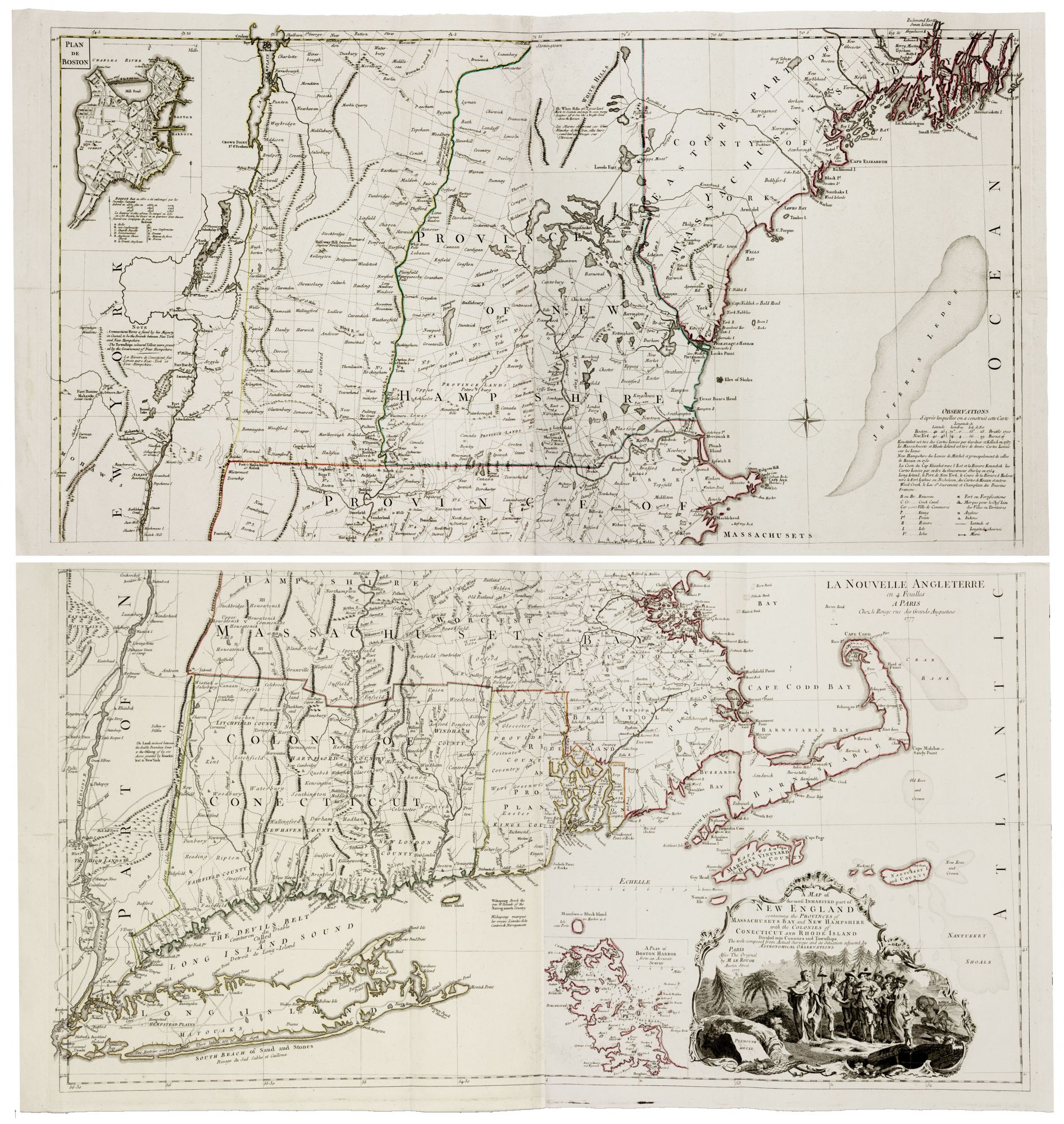
[New England/ Boston/ Revolutionary War] A Map of the most Inhabited part of New England… [Second title:] La Nouvelle Angleterre en 4 Feuilles…1777.
On four sheets, joined to form two, each measuring 508 x 952 mm (20 x 37.4 inches). Put together, the map measures 1016 x 1904 mm (40 x ca. 80 inches). Original outline color; several tiny halls on the lower sheet by the folding line; otherwise, excellent.
An exceptional example of the very scarce, full-scale, French edition of the great Jefferys-Mead map of New England. It is an exact and finely engraved rendition of the English original except for occasional translations of notations and place names into French and the reversal of the imagery in the handsome cartouche. The Jefferys was "the most detailed and informative pre-Revolutionary map of New England, . . . [and] its large size allowed the delineation of town borders as well as the inclusion of numerous place names not available on any earlier map of the region in manuscript or in printed form" (Benes). As a result, cartographic light was shed on places like Vermont, New Hampshire and even parts of Connecticut, which had received scant attention on previous maps of the Northeast. New townships in New Hampshire and Vermont are included along with a note concerning the New Hampshire-New York border. In the inset plan of Boston at upper left, streets and major structures are identified, and several major fires during the city’s history are noted. To the left of the cartouche is a chart of Boston Harbor.
Jefferys’ map was based primarily on an extremely rare and little known work by the Boston physician, William Douglass, that was posthumously published in 1753. Douglass spent 20 years in preparing his remarkable map. Jefferys’ map was compiled from this and other sources by the very talented though troubled Braddock Mead. Records of the period (see Cumming reference below) indicate that Mead was "on the lam" in London through most of his career for attempting to coerce a 12-year old Irish heiress into marriage, which was at the time punishable by death in Ireland, Mead's homeland. Mead worked in London under the assumed names of Rogers and John Green until his suicide in 1757.
Georges-Louis Le Rouge (c. 1712-c. 1790) was the most prolific publisher of maps and charts of North America during the period of the American Revolution, many of which were re-engravings of the best English maps of the day. He published both an atlas of charts, in which the present work appeared—the Neptune Americo-Septentrional—and the Atlas Ameriquain Septentrional, also in 1778, described as “the best collection of French maps for North America during the Revolutionary War” (Cobb, Krieger). A former German military officer, Le Rouge established a successful map business in Paris and attained the title of “Ingenieur Geographe du Roi.”
* McCorkle 777.12; Sellers and Van Ee 802; cf. Benes, P. New England Prospect no. 12, pp. 15-16; cf. Cobb, Krieger et al, Mapping Boston, pl. 16, pp. 100-101, cf. fig. 2, p. 41; cf. Cumming, W.P. British Map of Colonial America pp. 45-47; cf. Stevens & Tree 33 c, pp. 70-71 in Tooley, Mapping of America; cf. Goss, J. Mapping of North America no. 66.
Price: $8,500.00