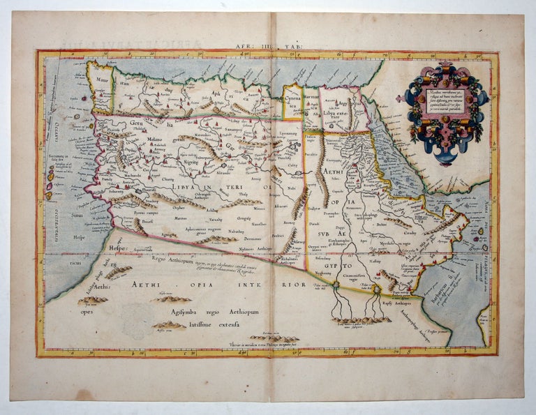
Afr: IIII. Tab:.
13 3/8 x 18 ½ inches. Fine hand color; excellent condition.
The most general of the four Ptolemaic maps of Africa from Mercator’s definitive edition of Ptolemy’s geography. It extends far enough south to fully show Ptolemy’s enduring source of the Nile River, the “Mountains of the Moon,” from which streams emanate to feed two lakes that in turn feed the Blue and White Nile rivers.
The map shows the area as it was known in the Roman Imperial period. It was based on geographic data and mapmaking instructions left by Alexandrian astronomer and geographer, Claudius Ptolemy (fl. A.D. 127-180), whose work laid out the fundamental principles of cartography that are followed to this day. Gerard Mercator (1512-1594), the great Flemish geographer, produced the most faithful and accurate edition of Ptolemy’s geography. In particular, his maps conformed more closely to Ptolemy’s original design than any of the several earlier editions. Mercator’s became the standard text, with many editions following this one as late as the 18th century.
Mercator in 1540 published Literarum latinarum, the first instructional handbook in the use of the italic hand to appear outside of Italy. It was also the first work to offer instruction in the use of italic script in the engraving of maps. This and the other maps in Mercator’s Ptolemy are arguably the finest demonstrations Mercator provided in the use of italics. Moreover, “the beauty and legibility of the best sixteenth and severteenth-century Dutch maps can be traced in large measure to Mercator’s influence”/ (Karrow, p. 382).
* Karrow, R. Mapmakers in the Sixteenth Century, pp. 376-406.
Sold