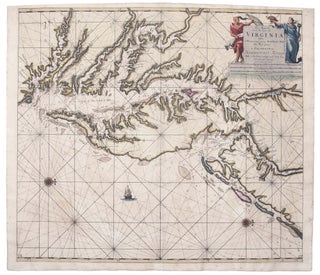
Virginia/ Maryland.
[Amsterdam, [c. 1695]
Pas Kaart van de Zee Kusten van Virginia.
A superb example of this striking, large-scale chart of the Chesapeake Bay, the lower waterways of Virginia, and Delaware Bay. It was one of the first charts to fully utilize the pivotal Augustine Hermann map of 1673, even using Hermann’s symbols for the plantations along the Bay and various rivers..... More